

Another beautiful sunrise over Pagosa Country – pic taken 7/11/2026
Saturday – 11 Jul 2026 – 3:30pm
The past…
Stevens Field Observations
Thursday: High: 88, Low: 53, Peak wind: 33mph, Afternoon humidity: 7-9%
Friday: High: 88, Low: 48, Peak wind: 26mph, Afternoon humidity: 7-9%
| Average High | Record High / Year | Average Low | Record Low / Year |
| 83 | 93 / 1958 | 44 | 25 / 1915 |
Precipitation summary… There has been no recent measurable precip.
Current satellite, radar, and smoke…
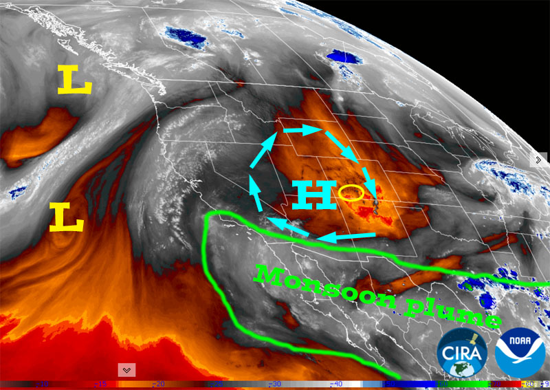
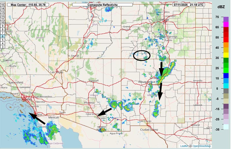
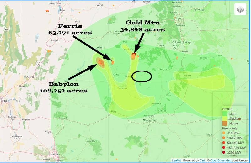
(Archuleta County is circled in black. Acreage totals are from Saturday morning.)
Forecast highlights…
*** Fire danger remains very high. The entire San Juan National Forest and Archuleta County are under stage 2 fire restrictions. ***
*** This weekend will be mostly dry, but there’s a slight chance for a spotty storm each afternoon. ***
*** The MONSOON will slowly ramp up next week. Monday through Thursday there will be spotty storms with low precip amounts. Friday and through next weekend will be more active with better chances for soaking showers. ***
Rest of Saturday and Sunday… We are on the dry and stable side of the high. There’s a chance for a few spotty storms into Saturday evening. Storms will move north to south.
Sunday is a transition day with a little more moisture and a little more instability so there will be a few more spotty afternoon storms. Storms will move northeast to southwest. Consider yourself lucky if you get a few raindrops.
High temps over the weekend will be 5-10 degrees above average.
*** Fire danger will remain high. ***
Monday through next weekend… The monsoon will slowly ramp up across the region!
Monday through Thursday there will be spotty afternoon and evening storms each day with low precip amounts.
Friday and through next weekend, afternoon and evening storms will increase. Storms will be more capable of producing short periods of heavy rain over small areas.
There will be rain lottery winners and losers. Do your rain dances!
Temps…
Saturday night lows will be in the mid 40s to low 50s.
Sunday highs will be in the high 80s to the mid 90s and lows will be in the mid 40s to the low 50s.
Monday through next weekend highs will be in the low 80s to near 90 and lows will be in the high 40s to mid 50s.
Winds…
Saturday and Sunday, each afternoon gusts will be 15-20mph.
Monday through next weekend, each afternoon gusts will be 15-20mph. Isolated stronger gusts are likely near showers and thunderstorms.
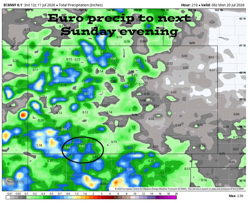
19 to 26 Jul… The subtropical high pressure will remain over the Four Corners region. This isn’t ideal, but the moisture in place will be recirculated into scattered storms each afternoon and evening.
Precipitable water is pretty high for much of this period, so showers will be capable of producing brief periods of heavy rain over small areas.
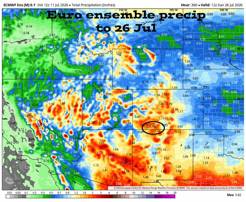
Forecast precip amounts have been fairly consistent over the last two days.
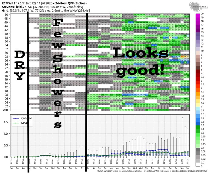
It’s mostly dry Saturday. Late Sunday afternoon through Thursday evening there’s a chance for spotty storms with low precip amounts. Starting Friday afternoon and going through the rest of the period, there’s a better chance for scattered afternoon and evening storms.
The next post will be Tuesday afternoon.
– Shawn


