

The Piedra River is running high and cloudy with snow run-off – pic taken 5/15/2026
Friday – 15 May 2026 – 5:30pm
The past…
Stevens Field Observations
Wednesday: High: 80, Low: 40, Peak wind: 35mph
Thursday: High: 74, Low: 42, Peak wind: 29mph
| Average High | Record High / Year | Average Low | Record Low / Year |
| 69 | 80 / 1984 | 30 | 14 / 1913 |
Precipitation summary… A few lucky folks got up to 0.05” of rain Wednesday evening.
Current satellite and radar…

Radar late Friday afternoon shows a few weak showers on the north side of The Divide.
Forecast highlights…
*** Wind gusts over 30mph Saturday, Sunday, Monday, and Tuesday. ***
*** Saturday and Sunday, each afternoon humidity in the mid teens and gusty winds will cause elevated FIRE DANGER. ***
*** Potential for blowing dusting late Sunday afternoon into Sunday night. ***
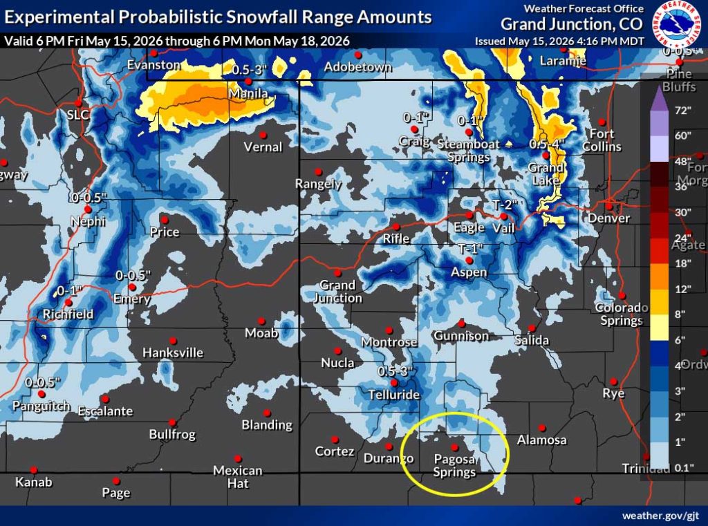
*** Scattered showers Sunday night and Monday morning. 1-3” of snow is possible on Wolf Creek Pass. ***
*** Tuesday through next Friday there will be lots of sun and breezy afternoons. ***
Forecast details…
Friday night into Sunday evening… The ridge has moved to our east and now the pressure gradient will gradually increase leading to gusty winds.
Dry air, low relative humidity, and gusty winds will also lead to increased fire danger Saturday and Sunday afternoons and into each evening.
Sunday night through Monday morning… A low will move through central UT Sunday night and then through northern CO Monday and cause gusty winds across the region. We’ll catch the tail-end of the cold front and some scattered showers and an isolated thunderstorm or two.
Wind gusts will be 35-40mph, but more clouds, cooler temps, and higher humidity will ease fire danger a tiny bit.
Precip forecast…
Mountains above 9,000ft: 1-3” of snow
Pagosa Springs area: up to 0.10” of rain, graupel, or small hail
Monday afternoon through next Friday… Drier air will move in and we’ll see lots of sun. Gusty afternoon will persist.
Temps…
Friday night lows will be in the low 30s to low 40s.
Saturday highs will be in the low 70s to near 80 and lows will be in the mid 30s to the low 40s.
Sunday highs will be in the mid 60s to low 70s and lows will be in the low to high 30s.
Monday highs will be in the mid 50s to the low 60s and lows will be in the mid 20s to the mid 30s.
Tuesday highs will be in the near 60 to near 70 and lows will be in the high 20s to the high 30s.
Wednesday highs will be in the mid 60s to the low 70sand lows will be near 30 to near 40.
Thursday and next Friday highs will be near 70 to the high 70s and lows will be in the low 30s to low 40s.
Winds…
Saturday afternoon gusts will be around 30mph in the Pagosa area and 40-45mph in the high country.
Sunday afternoon and evening gusts will be around 35mph in the Pagosa area and 50-60mph in the high country.
Monday morning into the afternoon gusts will be 35-40mph in the Pagosa area and 55-65mph in the high country.
Tuesday afternoon gusts will be around 30mph in the Pagosa area and 35-45mph in the high country.
Wednesday afternoon gusts will be 25mph in the Pagosa area and 30-40mph in the high country.
Thursday and next Friday, each afternoon gusts will be around 20mph in the Pagosa area and 30-35mph in the high country.

22 May to 30 May… Starting around 23 May, there will be a little more moisture and a little more instability so we could see hit and miss afternoon showers and thunderstorms.


It’s dry through Sunday afternoon and then we get scattered showers Sunday night through Monday morning. It’s dry again Monday afternoon through next Friday. Starting around 23 May, the pattern is trying to get more active with hit and miss afternoon convective showers.
The next post will be Sunday afternoon.
– Shawn


