

Tommy “supervised” Arleen measuring snow this morning. We have an average snow depth of 18”. There is a big variance due to drifting. – Pic taken 2/21/2026
Monday – 23 Feb 2026 – 5:30pm
The past…
Stevens Field Observations
Friday: High: 26, Low: 2, Peak wind: 36mph at 10:10am
Peak wind on Tuesday, 17 Feb: 58mph
Peak wind on Wednesday, 18 Feb: 55mph
| Average High | Record High / Year | Average Low | Record Low / Year |
| 43 | 64 / 1958 | 9 | -22 / 1955 |
Precipitation summary…
Wolf Creek daily snow totals…
21 Feb: 15”
20 Feb: 17”
19 Feb: 15”
18 Feb: 12”
17 Feb: trace
Total: 59”
Most of the Pagosa area got 12-20” of snow over the last 5 days. The snow winner was Terri and Rick in Lost Valley with 31.5”!


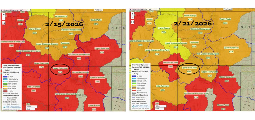
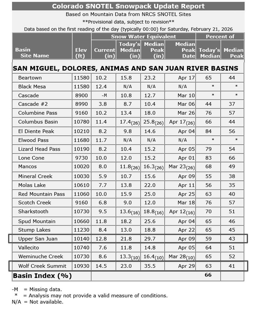
Both are roughly 9” of liquid equivalent behind. That means they need 90” of 10:1 ratio snow to get to average. It would take two more big storm cycles like the one we just had to get to average.
Current satellite and radar…
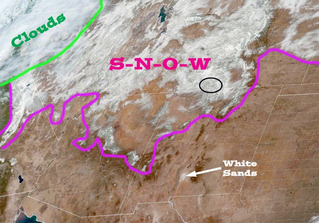
There is nothing on radar late Saturday morning in our area.
Forecast highlights…
*** AVALANCHE ADVISORY for the mountains through the weekend. Large and deadly avalanches will be easy to trigger. ***
*** Slight chance for spotty mountain snowshowers Wednesday and Thursday. Otherwise, we’ll see lots of blue sky, a gradual warming trend, and will be dry through the week. ***
Forecast details…
Saturday through next Saturday… A ridge will build over the region. We should see lots of sun and a warming trend.
Wednesday and Thursday a weak trough will move through northern Colorado and could kick up spotty snowshowers along The Divide. A few lucky spots in our mountains could get an inch of snow.
Temps…
Saturday highs will be in the mid 30s to low 40s and lows will be near zero to the mid teens.
Sunday highs will be in the low to high 40s and lows will be near 10 to the high teens.
Monday through next Saturday highs will be in the high 40s to the mid 50s. and lows will be in the mid teens to the mid 20s.
Winds…
Saturday through Tuesday each afternoon, gusts will be around 10mph in the Pagosa area and 25-30mph in the high country.
Wednesday through next Saturday, each afternoon gusts will be 15-20mph near Pagosa and 35-40mph in the high country.
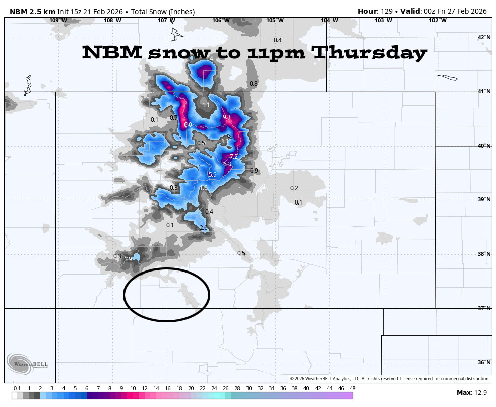
The northern Colorado mountains will be favored.
1 Mar to 9 Mar… Our nemesis, the big evil ridge, will set up over the west coast. Weak systems will try to sneak through from the northwest (not favorable for us) towards the end of this period. I don’t see anything “fun” for us on the horizon.

It expects us to be dry through Tuesday, and then there’s a slight chance for a little precip Wednesday and Thursday. Then we’re dry again through 2 Mar. Finally, 3-7 Mar could more active, but this indicates a weak pattern with poorly organized storms.
The next post will be on Monday.
– Shawn


