

Pagosa Peak made a glorious appearance this morning – pic taken 2/19/2026
Thursday – 19 Feb 2026 – 2:15pm
The past…
Stevens Field Observations
Wednesday: High: 30, Low: 17, Peak wind: 55mph at 2:03pm
| Average High | Record High / Year | Average Low | Record Low / Year |
| 44 | 63 / 1981 | 8 | -25 / 1942 |
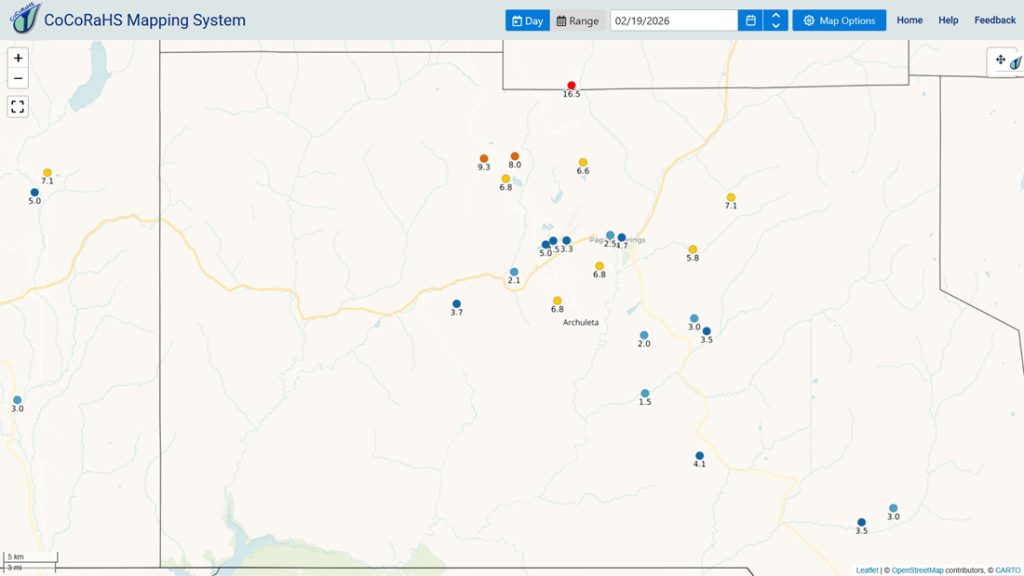
Precipitation summary… Wolf Creek reported 15” of snow in the last 24 hours bringing the storm total 27”.
Current satellite and radar…


Forecast highlights…
*** Round 3 snow will hit us hardest roughly midnight tonight to noon tomorrow. ***
These are NEW advisories and warnings…
*** WINTER WEATHER ADVISORY for the San Juan River Basin. This includes Pagosa Springs. 3-6” of snow and winds gusting to 35mph are expected 11pm Thursday to 11pm Friday. ***
*** WINTER WEATHER WARNING for the eastern San Juan Mountains above 10,000ft. This includes Wolf Creek and Cumbres Passes. Up to 15” of snow and winds gusting to 55mph are expected 11pm Thursday to 11pm Friday. ***
*** AVALANCHE WARNING for the mountains valid through Friday. ***
*** Next week’s storm is trying to go POOF. We could be dry for a while. ***

Forecast details…
Late Thursday evening into Friday evening… Round 3. The final trough will move through.
Timing…
Late Thursday evening scattered snowshowers will increase over the mountains.
Roughly midnight tonight until around noon Friday bands of moderate to heavy snow will move through. Expect periods of low visibility and blowing snow. There’s also a slight chance for thundersnow.
Early Friday afternoon scattered snowshowers will end in the Pagosa area.
Friday evening scattered snowshowers will end over the mountains.
Snow amounts…
Wolf Creek area: 10-15”
Pagosa area: 4-9”

Saturday, Sunday, Monday, and most of Tuesday… A ridge will build over the region. We should see lots of sun and a warming trend.
Tuesday clouds will increase ahead of a potential storm.
Wednesday and next Thursday (25 and 26 Feb)… I’m losing faith that the next storm will impact us. For now, I’m not making any significant changes, but this storm could go “poof”.
It will be a warmer storm with snow levels around 9,000ft during the day around 8,000ft at night. Snow in the valley would fall at night and then melt during the day.
Rough first guess snow amounts…
Mountains above 9,000ft: 3-6”
Pagosa area above 8,000ft: up to 1”
Pagosa area below 8,000ft: a dusting
*** Forecast confidence is low for this storm. I’ll adjust the details as the data gets better. ***
Temps…
Thursday and Friday highs will be in the mid-20s to low 30s. Thursday night lows will be in the high single digits to the mid teens. Friday night lows will be -10 to +5.
Saturday highs will be in the mid 30s to low 40s and lows will be in the low single digits to the mid teens.
Sunday highs will be in the low to high 40s and lows will be near 10 to the high teens.
Monday and Tuesday highs will be in the high 40s to the mid 50s. Monday night lows will be in the mid teens to mid 20s. Tuesday night lows will be in the mid 20s to low 30s.
Wednesday and next Thursday highs will be in the mid 40s to the low 50s and lows will be in the mid 20s to low 30s.
Winds…
Thursday afternoon gusts will be 20-25mph in the Pagosa area and 30-40mph in the high country.
Friday afternoon gusts will be 25-35mph in the Pagosa area and 45-55mph in the high country.
Saturday, Sunday, and Monday each afternoon, gusts will be around 10mph in the Pagosa area and 25-30mph in the high country.
Tuesday afternoon gusts will be around 15mph in the Pagosa area and 30-35mph in the high country.
Wednesday and next Thursday, afternoon gusts will be around 20mph near Pagosa and 35-40mph in the high country.
26 Feb to 6 Mar… Most of this period looks dry.
I’ll try to do a post each day through Saturday. Keep an eye out on Facebook for quick updates.
– Shawn


