

Standing lenticular clouds over our mountains yesterday – Pic taken 2/9/2026
Tuesday – 10 Feb 2026 – 5:30pm
The past…
Stevens Field Observations
Sunday: High: *55*, Low: 18, Peak wind: 18mph
Monday: High: 54, Low: 19, Peak wind: 23mph
* One degree short of the record high of 56 set in 1970 *
| Average High | Record High / Year | Average Low | Record Low / Year |
| 42 | 57 / 1996 | 7 | -28 / 1949 |
Precipitation summary… There has been no recent measurable precip.
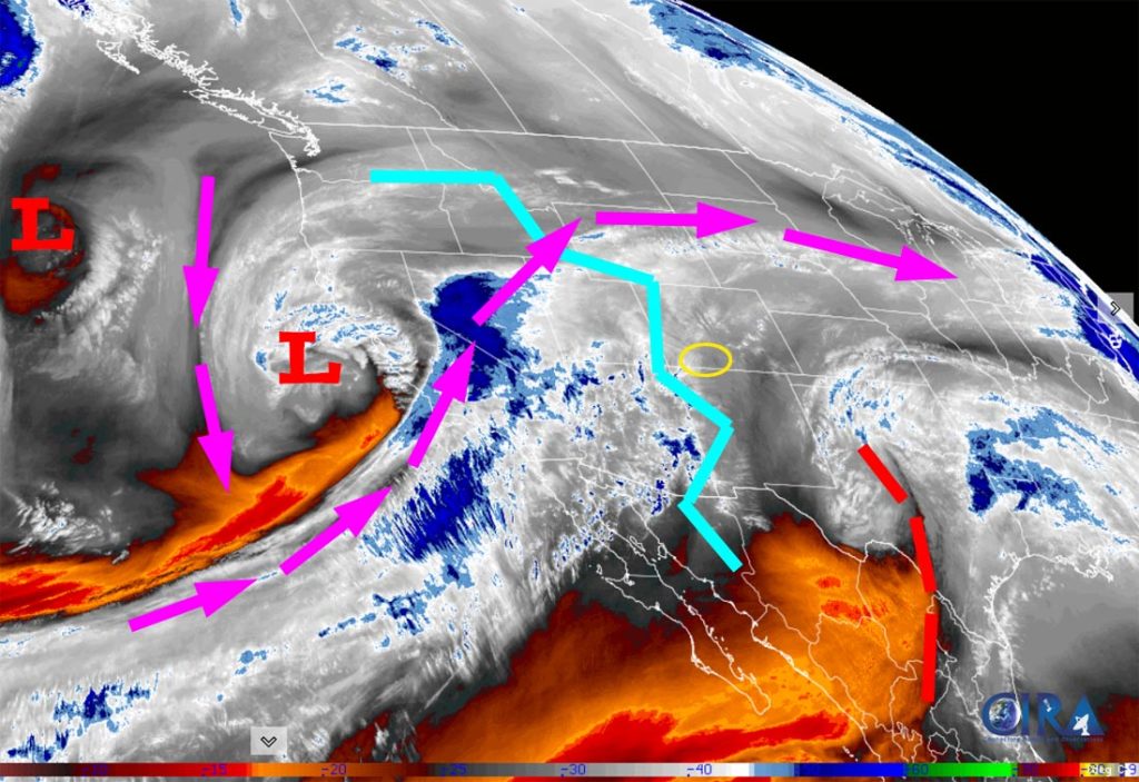
Current satellite and radar…

Forecast highlights…
*** Storm 1 is Wednesday morning into Thursday morning. Mostly rain in the Pagosa area and snow in the mountains. ***
*** Storm 2 is Friday morning into early Saturday morning. Rain and snow in the Pagosa area and snow in the mountains. ***
*** Storm 3 is 16-19 Feb. This one will be colder and should be all snow. ***
Forecast details…
After sunrise Wednesday through Thursday morning… Storm 1 will move through. Moisture and storm energy are both weak, so my expectations are low. The best chance for precip is late Wednesday morning into Wednesday evening.
Snow levels… Sunrise Wednesday: around 7,500ft. Wednesday afternoon: up to 9,000ft. Wednesday around midnight: 8,500ft. Thursday around sunrise: 8,000ft
Snow amounts…
Wolf Creek area: 2-4”
Pagosa area above 8,000ft: a dusting to 1”
Pagosa area below 8,000ft: mostly “rainflakes” – a dusting of snow at best
Thursday afternoon into Thursday night… There will be a brief break between systems. A few spotty showers are possible, mostly over the mountains, but precip amounts will be minimal.
Friday morning into early Saturday morning… Storm 2 will move through. It’s similar to the first storm. The best chance for precip is late Friday morning into Friday evening.
Snow levels… Sunrise Friday: around 7,800ft. Friday afternoon: around 8,000ft. Late Friday evening: around 7,600ft. Sunrise Saturday: around 6,800ft
Snow amounts…
Wolf Creek area: 2-4”
Pagosa area above 7,800ft: a dusting to 1”
Pagosa area below 7,800ft: mostly “rainflakes” – a dusting of snow at best

The yellow circle is around Archuleta County.
Saturday morning into Monday morning… A transient ridge will move through. Skies will be variably cloudy and we’ll stay dry.
Monday afternoon through next Wednesday… Storm 3 will move through. The jet stream, storm energy, moisture, and orographic lift are trying to line up for a decent storm.
The details of this storm are still unclear, but here’s my rough first guess…
The best chance for precip is early next Tuesday morning into next Wednesday morning.
Snow levels… Monday afternoon: around 8,000ft. Midnight Monday: around 7,000ft. Rest of this period: below 7,000ft
Snow amounts…
Wolf Creek area: 10-15”
Pagosa area above 7,600ft: 4-7”
Pagosa area below 7,600ft: 2-4”
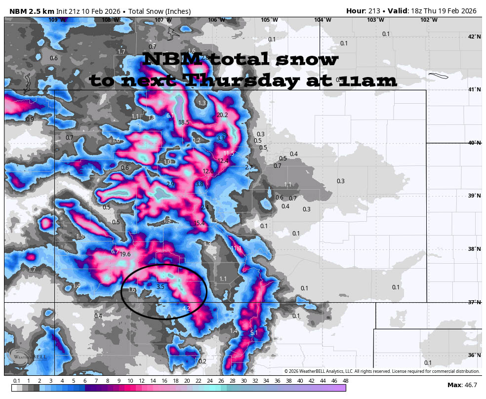
Forecast snow amounts vary considerably, but this looks reasonable to me at this time.
*** As always, I will adjust the details as the data gets more reliable. ***
Temps…
Tuesday night lows will be in the mid 20s to low 30s.
Wednesday highs will be in the mid to high 40s and lows will be in the mid 20s to low 30s.
Thursday highs will be in the high 40s to mid 50s and lows will be in the mid 20s to low 30s.
Friday highs will be in the low to high 40s and lows will be near 20 to near 30.
Saturday, Sunday, and Monday highs will be in the high 40s to mid 50s. Lows Saturday and Sunday will be in the high teens to mid 20s. Lows Monday night will be in the low to high 20s.
Next Tuesday highs will be in the mid 30s to low 40s and lows will be in the low to mid 20s.
Winds…
Wednesday and Thursday, each afternoon gusts will be 15-20mph near Pagosa and 30-35mph in the high country.
Friday and Saturday, each afternoon gusts will be around 10mph near Pagosa and around 20mph in the high country.
Sunday afternoon gusts will be around 15mph near Pagosa and 25-30mph in the high country.
Monday and next Tuesday, each afternoon gusts will be 20-25mph near Pagosa and 35-45mph in the high country.
17 Feb to 25 Feb… The first few days of this period will be active and then there is a lot of uncertainty. Unfortunately, I think the evil ridge will try to build back over the southwest US.

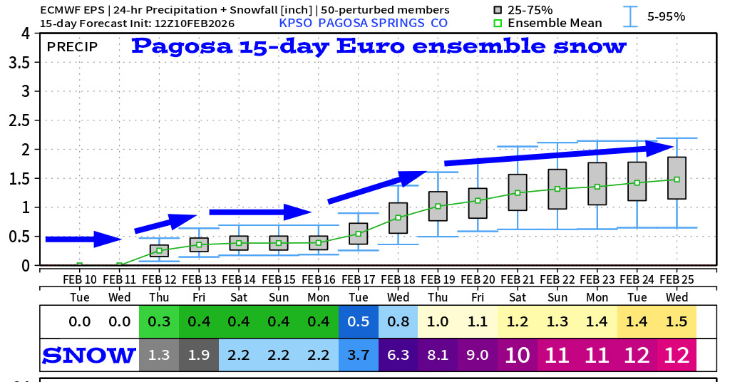
Two notes: 1. The first two storms will be warm and mostly rain, so I don’t buy the 2.2” by Saturday. 2. I think this model is overdoing next week’s storm a bit.
Unless there’s a big change to my forecast, the next post will be on Thursday.
– Shawn


