

Tommy and yet another one of his girlfriends up at Williams Creek Reservoir – Pic taken 2/7/2026
Sunday – 8 Feb 2026 – 3:30pm
The past…
Stevens Field Observations
Friday: High: 58, Low: 20, Peak wind: 8mph
Saturday: High: 53, Low: 24, Peak wind: 12mph
| Average High | Record High / Year | Average Low | Record Low / Year |
| 41 | 56 / 1970 | 6 | -26 / 1989 |
Precipitation summary… There has been no recent measurable precip.
Current satellite and radar…

There is nothing on radar in our area Sunday afternoon.
Forecast highlights…
*** Lots of sun and temps near record highs through Tuesday. ***
*** Storm 1 is early Wednesday morning into Thursday morning. Mostly rain in the Pagosa area and snow in the mountains. ***
*** Storm 2 is late Thursday night into early Saturday morning. Rain and snow in the Pagosa area and snow in the mountains. ***
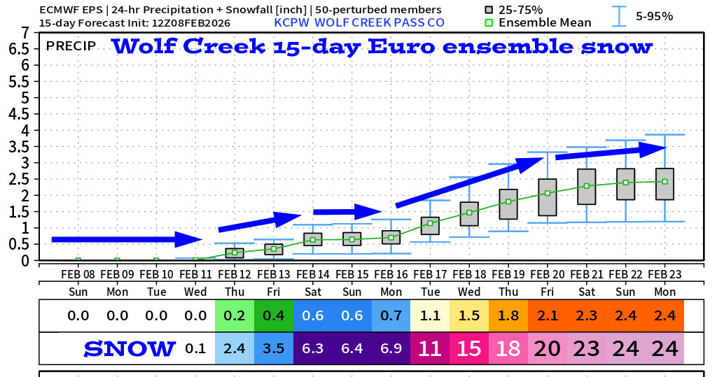
*** Storm 3 is 16-19 Feb. This one will be colder and should be all snow. ***
Forecast details…
Sunday night through Tuesday evening… The ridge will shift to our east Tuesday, and then more clouds will move into the area from the southwest, but we’ll stay dry.
Early Wednesday morning through Thursday morning… Storm 1 will move through. Moisture and storm energy are both weak, so my expectations are low. The best chance for precip is late Wednesday morning into Wednesday evening.
Snow levels… Wednesday morning: around 8,000ft. Wednesday afternoon: up to 9,000ft. Wednesday around midnight: 8,500ft. Thursday around sunrise: 8,000ft
Snow amounts…
Wolf Creek area: 2-4”
Pagosa area above 8,000ft: a dusting to 2”
Pagosa area below 8,000ft: mostly “rainflakes” – a dusting of snow at best
Thursday afternoon into Thursday evening… There will be a brief break between systems. A few spotty showers are possible, mostly over the mountains, but precip amounts will be minimal.
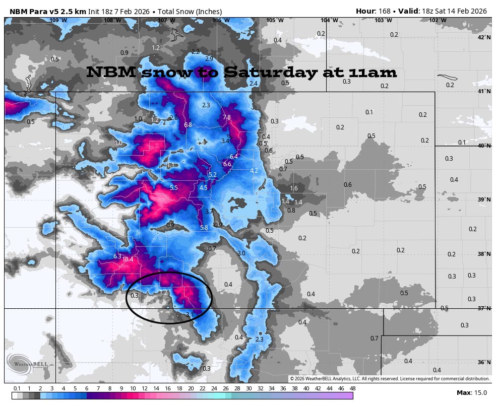
Late Thursday night into early Saturday morning… Storm 2 will move through. It’s a little more organized with better moisture and storm energy. The best chance for precip is late Friday morning into Friday evening.
Snow levels… Late Thursday night: around 7,800ft. Sunrise Friday: around 7,200ft. Friday afternoon: around 7,800ft. Late Friday evening: around 7,000ft. Sunrise Saturday: around 6,500ft
Snow amounts…
Wolf Creek area: 3-6”
Pagosa area above 7,800ft: 1-2”
Pagosa area below 7,800ft: a dusting to 1”
Saturday afternoon through next Sunday… A transient ridge will move through. Skies will be variably cloudy and we’ll stay dry.
Temps…
Sunday night lows will be in the high teens to high 20s.
Monday and Tuesday highs will be in the low to high 50s. Monday night lows will be near 20 to the high 20s. Tuesday night lows will be in the mid 20s to low 30s.
Record high on Sunday, 8 Feb: 56
Record high on Monday, 9 Feb: 56
Record high on Tuesday, 10 Feb: 57
Wednesday and Thursday highs will be mid to high 40s and lows will be in the mid 20s to low 30s.
Friday and Saturday highs will be in the low to high 40s and lows will be near 20 to near 30.
Winds…
Each afternoon gusts will be 15-20mph near Pagosa and 30-35mph in the high country.
15 Feb to 23 Feb… The models continue to indicate an active weather pattern. Another system is trying to take shape 16-19 Feb. And it will be colder so it should be all snow for Pagosa Springs.

If there’s a significant change to my forecast, I’ll do another post tomorrow. Otherwise, the next post will be on Tuesday.
– Shawn


