

We had a beautiful harvest sunrise this morning! – pic taken 10/22/2025 7:00am
Wednesday – 22 Oct 2025 – 4:15pm
Weather: The past…
Stevens Field Observations
Tuesday: High: 63, Low: 27, Peak Wind: 10mph
Wednesday: High: 64, Low: 27, Peak Wind: 12mph
| Average High | Record High / Year | Average Low | Record Low / Year |
| 60 | 78 / 1940 | 23 | 0 / 1908 |
Precipitation summary and river levels… There has been lots of sun and no precip in the last 2 days.
Current satellite and radar…
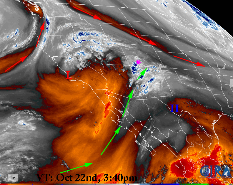
Water vapor satellite Wednesday afternoon – Cutoff Low over southern California is wrapping around and headed right at us giving us ideal southwest flow as it approaches. Moisture is moving in from Baja area.

Rain showers are moving East-northeast towards Archuleta county and Pagosa Springs. This first round may miss us to the south except perhaps Chromo.
Forecast highlights…
*** Late tonight through Thursday will see off & on rainshowers and a sprinkle of mountain snow ***
*** Friday and Saturday will be nice. ***
*** Sunday and Monday we might catch the southern end of a trough and a few scattered showers. ***
Forecast details…
Wednesday night and Thursday… A closed off low (again) moves directly over us bringing cloudy skies and scattered rainshowers and a slight chance of thunderstorms in the lower elevations and snow and thunderstorms above 11,000 feet and above 10,000 feet after 5pm.
The best chance for precip is Thursday morning through Thursday evening. The Wolf Creek area will get a dusting to 3” of snow. Snow showers over the mountains may continue into Friday.
Friday and Saturday… Clearing clouds Friday morning. Then transient ridging will give us partly cloudy skies, dry weather, and temps near average.
Sunday and Monday… A trough will skirt to our north. We’ll have mostly cloudy skies and a few spotty showers and thunderstorms mostly skirting the mountains to the north. Precip amounts will be low unless the system dips farther south.
Tuesday… Ridge takes control with partly cloudy skies, dry weather, and temps near average.
Temps…
Wednesday highs will be in the mid 60s and lows will be in the mid 30s.
Thursday through Tuesday highs will be in the mid-50s to low 60s and lows will be in the low 20s to the high 20s.
Winds…
Gusts each afternoon through Saturday and again Tuesday will be 15-20mph.
Sunday and Monday afternoon gusts will be 25-30mph.
*** As always, stronger isolated gusts are likely near a shower or thunderstorm. ***

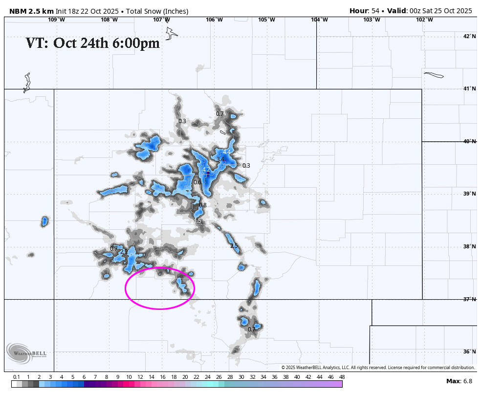
The 8-14 day period… The models show a northerly system around 26-28 Oct and a system the first week of November but are otherwise mostly dry.
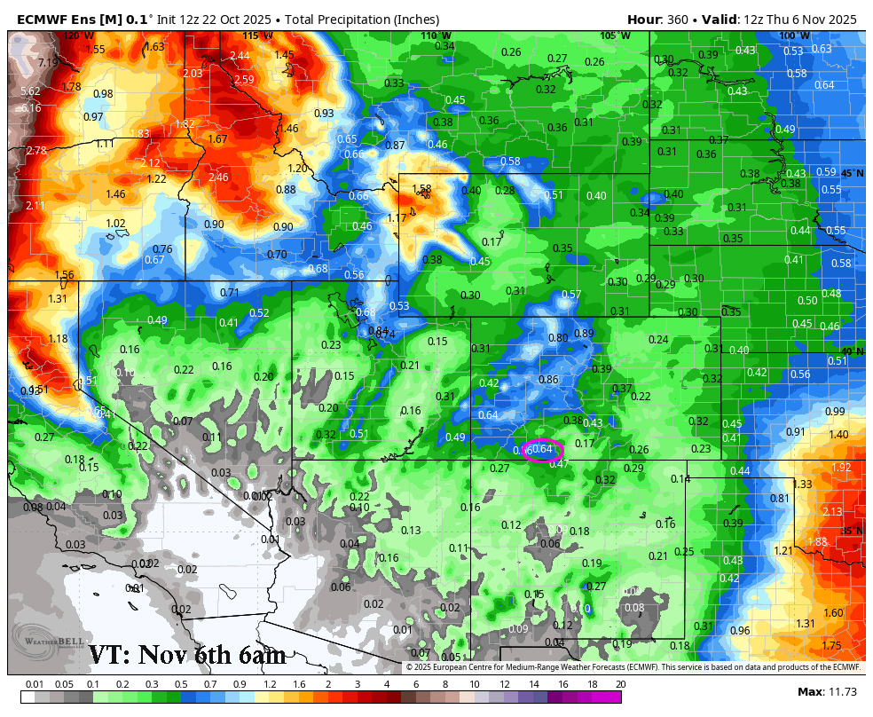
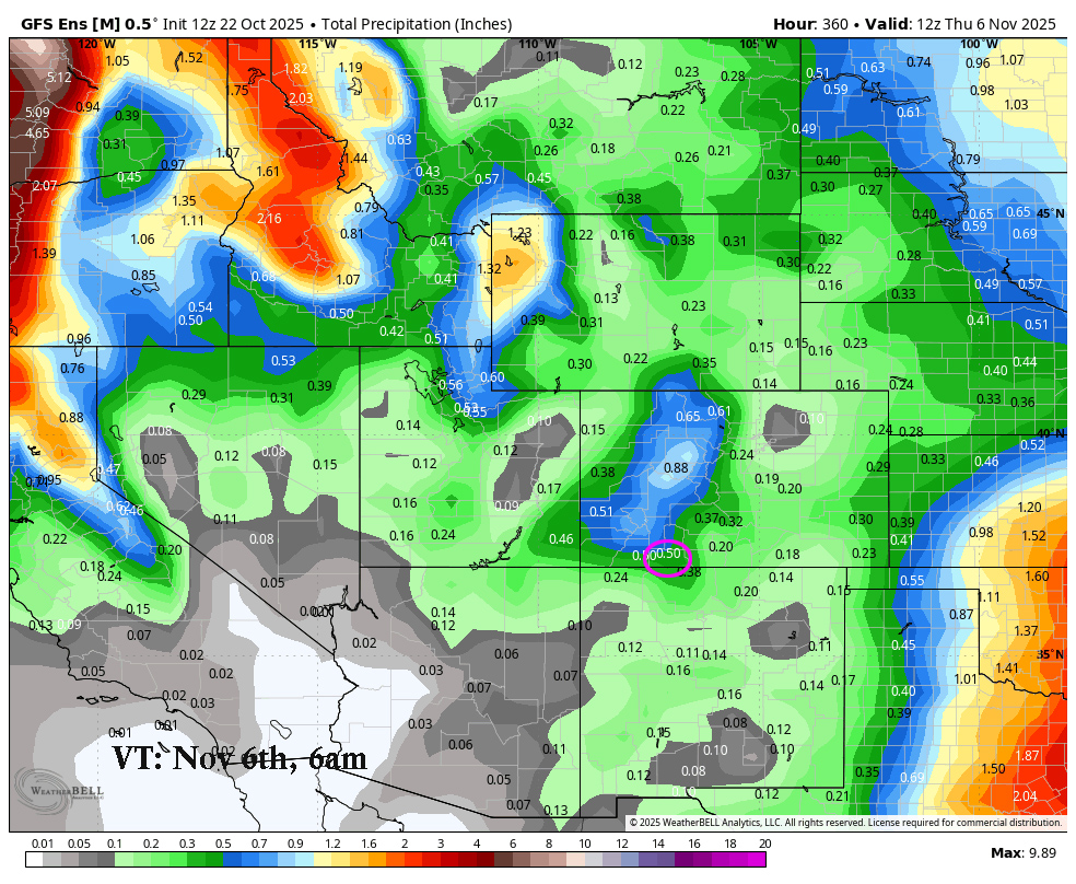
On the top, Euro ensemble precip to 6 Nov at 6am shows 0.64” in the Pagosa area. On the bottom, GFS ensemble precip shows 0.50”. I expect the storm track to stay to our north, and I do not expect much precip during this period outside of tomorrow.
My next post will be on Friday.
Tomorrow NIGHT: Creation Care Pagosa Presents Dr. Nardi & a Discussion on Extreme Weather Events
Dr. Kyle Nardi, scientist at the National Center for Atmospheric Research (NCAR) in Boulder, is speaking in Pagosa Springs on Thursday, October 23rd. Dr. Nardi specialized in researching the impact of extreme weather events on public lands and nearby communities.
Thursday, October 23
Community United Methodist Church
434 Lewis Street
Doors open at 6:00 pm – Presentation will run 6:30 to 7:30
– Arleen


