

Tanker dropping fire retardant on Oak fire in Aspen Springs this afternoon. Photo Credit to Brianna Webster.
The Oak Fire was reported shortly after 1:26pm on Sunday afternoon. As of 5:30pm this afternoon the fire was up to 52acres. There are air tankers on the fire. Smoke will settle in Pagosa area Monday morning and could be into the unhealthy category.
Sunday – 10 Aug 2025 – 5:30pm
The past…
At Stevens Field the high temperature on Saturday was 86 and so far today (Sunday) it has been 81. The low on Thursday morning it was 45 and this morning it was 51.
The minimum relative humidity Saturday afternoon was 8% with a dew-point of 16 and today (Sunday) was 12% with a dew-point of 21. This indicates it is still very dry. Remember, we want to see dew-points in upper 40s for good monsoon showers.
The peak wind at Stevens Field on Saturday was 33mph and today (Sunday) has been 28mp.
| Average High | Record High / Year | Average Low | Record Low / Year |
| 82 | 89 / 1972 | 46 | 28/ 1956 |
Precipitation summary… There hasn’t been any reports of rain the last few days.
Fire and smoke…
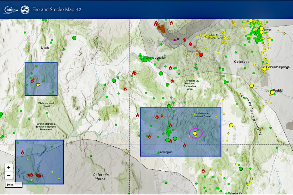
Fire.AirNow.gov site is showing Moderate air quality over Pagosa at this time. We have smoke coming into our area from a number of fires including the Oak Fire in Aspen Springs. Smoke will settle and be worse overnight and in the morning.
The Oak Fire was reported shortly after 1:26pm on Sunday afternoon. As of 5:30pm this afternoon the fire was up to 52acres. There are air tankers on the fire. A number of evacuations and per-evactuations are in effect. Smoke will settle in Pagosa area Monday morning and could be into the unhealthy category.
As of Sunday, The Middle Mesa Fire burning east of Navajo Lake just south of the CO/NM border is 5,050 acres and 27% contained.
The Stoner Mesa Fire west of Rico in Dolores county is up to 2,531 acres this afternoon and 0% contained. Smoke from the fire will be in the Archuleta County area from late Sunday to Late Monday night.
The Dragon Bravo Fire that is in Arizona and responsible for most of the smoke advecting into our area is at 143,489 acres and 37% contained.
Forecast discussion…
Satellite
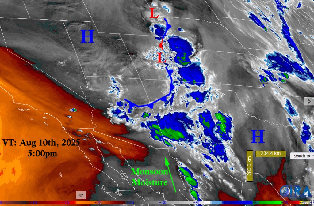
Satellite image: Valid Time August 10th, 5:00pm.
The “cold” front moved through yesterday. We were a few degrees cooler.
There is still a lot of mid and upper level clouds left in the area today from the front. There is a weak upper level disturbance slipping through this afternoon which is increasing our wind gusts. The ridge to the east will rebuild over the next few days and pull the monsoon moisture back into our area.
Radar

Radar image: Valid Time August 10th, 5:08pm. The shower activity has been pushed south with the monsoon moisture. There is nothing in the Archuleta county at this time. We could see a few sunset showers tonight.
Forecast highlights…
*** NOTE: Stage 2 Fire Restrictions are in effect for the entire San Juan National Forest!!!***
*** Stage 1 Fire Restrictions are in effect for Archuleta County***
*** Concerned about fire danger through the week with lots of sun, warm, dry, and gusty afternoon winds. ***
*** If you spot smoke, call Archuleta County dispatch at 970-731-2160. ***
Sunday through Saturday
The “cold” front moved through yesterday. We were a few degrees cooler.
We might see a few sunset showers tonight.
There is still a lot of mid and upper level clouds left in the area today from the front. There is a weak upper level disturbance slipping through this afternoon which is increasing our wind gusts. Smoke from the Stoner Mesa fire will be in the Archuleta County area from late Sunday to Late Monday night. Smoke from the Oak fire will settle in Pagosa area Monday morning and could be into the unhealthy category.
The ridge will try to rebuild over the next few days. Moisture will slowly advect into area with chance of precip increasing each day and chance of gusty winds decreasing. We’ll be partly cloudy to Mostly Cloudy each as we should see increasing clouds each afternoon.
There is a slight chance on for an isolated shower or thunderstorm every day. Best chances are on Tuesday and Saturday. Consider yourself lucky if you get enough rain to wet the ground. Unfortunately, isolated thunderstorms also means lightning without higher relative humidities and rain. So the chances of wildfire outbreaks increases.
Temps: Highs will will increase throughout the week from low-80s to upper 80s by Thursday before lowering into low80s by Saturday. Lows will be mid-40s.
Winds: Sunday will still have afternoon winds gusting to 30mph. The rest of the week will see afternoon gusts to 20mph. As always, stronger isolated gusts are likely near a shower or thunderstorm.
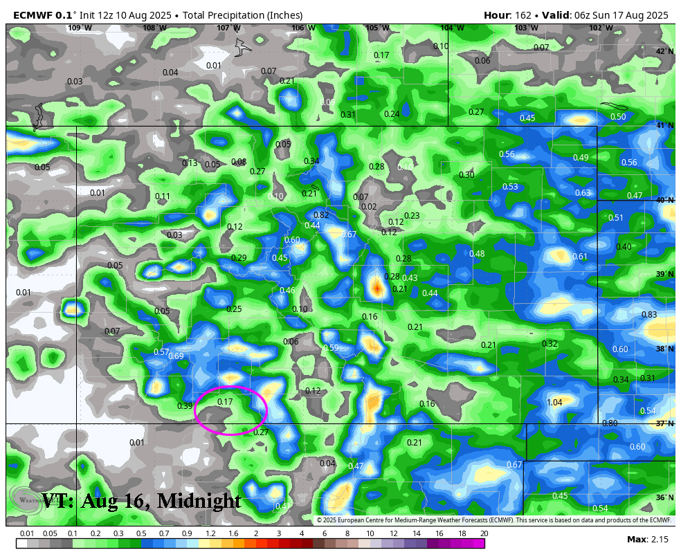
Total Precip Amounts from today through Saturday, the 16th at midnight. Up to .17 in the valley, heavier amounts to the north and the west. Up to 1.6″ in the mountains.
The 8-14 day period… A monsoon pattern with weak moisture and weak instability will persist. Expect isolated showers and thunderstorms most afternoons. Precip amounts will vary considerably.

The Euro model shows .45″ for Pagosa and up to 1.8″ for the mountains over the next two weeks.

The GFS model shows .77″ for Pagosa and up to 1″ for the mountains over the next two weeks.
We need a good, deep tropical moisture storm to give the southwest and the firefighters some relief.
Unless something interesting pops up, my next post will be Tuesday morning.
– Arleen


3 Responses
Hidden Valley Ranch – air quality measurements shot up to 156 around 7:30. Now down to 129 but still bad.
Thank you for the report Frank. Hoping when winds switch around tonight (Monday), this smoke will clear out.
Hi Arlene, it would be very helpful at this time if you could provide wind direction and speed information and projections.
Thank you,
Emily Deitz