

Satellite analysis the morning of 5 April 2025
Saturday – 5 Apr 2025 – 10am
Snow with easterly flow? It doesn’t happen too often in Pagosa Springs. And it’s tricky to forecast.
A little refresher…
The key is “orographic lift”. Our terrain and wind flow across that terrain are often the main impacts on our weather. Winds going towards and up the mountains – upslope – causes adiabatic cooling. Winds descending the mountains – downslope – causes adiabatic warming.
Adiabatic cooling: as air is forced upward, the pressure decreases and the air expands and cools. As the air cools closer to saturation, clouds and precip can form.
Adiabatic warming: as air descends down the mountains, pressure increases, the air compresses, warms, and dries.
In our region, the difference is easy to observe by looking at the vegetation. Pagosa Springs is on the “wet” side of the San Juan Mountains with prevailing southwest, upslope, flow. Our vegetation is mostly ponderosa pines and gamble oak. The San Luis Valley, at a similar elevation, is on the downslope side of the mountains and has very few trees and brush.
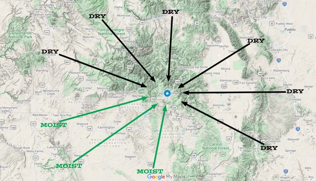
The odds are against Pagosa Springs getting precip with winds out of the northwest, north, east, and southeast. Deformation zone precip during the cold season is one way. Summertime showers and thunderstorms building over the mountains and then moving towards Pagosa is another. Let’s focus on deformation zone precip…
Mature low pressure systems to our south result in winds from the northeast, east, or southeast, depending on the low’s location and strength. A deformation zone forms when winds diverge aloft which adds lift and adiabatic cooling resulting in clouds and precip.

The size of a deformation zone varies depending on the strength of the low and upper level wind supporting the low. They’re often less than 100 miles wide and less than a couple hundred miles long.
Like most of our weather, the mountains make deformation zones difficult to forecast.
Sometimes the ingredients come together for the mid and upper-level deformation dynamics to overcome the low-level downslope dynamics.
There needs to be light mountain-top flow with the right low in the right place.
On 5 April 2025 the ingredients came together. Wolf Creek’s winds were less than 20mph out of the north and northeast and winds at Stevens Field were less than 10mph out of the northeast.

Note the higher totals along I-25 and near La Veta Pass. Low-level flow out of the east and northeast is upslope for that area. This is their heavy snow pattern.

This is one of the few ways that Pagosa Springs gets precip with downslope flow. It doesn’t happen too often.
Our mountain weather is always interesting. It’s a fun puzzle that often humbles me!
- Shawn


4 Responses
What a great and succinct explanation! Thanks for taking the time to put this out. It’s always good to learn something new.
Howard & Jean, I’m so glad you appreciated that article. We’ll try to do more in the future. Thank you, as always, for all your support!
Shawn & Arleen
Fascinating… And well explained!
Thank you for your kind words. And thank you for following us!
Shawn & Arleen