

Conditions were pretty good up at Wolf Creek yesterday – pic taken 2/18/2025
Wednesday – 19 Feb 2025 – 12:40pm
The past…
At Stevens Field the high temperature on Monday was 45 and on Tuesday it was 41. The low this morning was 7. The cold spots were around zero.
The peak wind at Stevens Field Monday afternoon was 24mph and on Tuesday afternoon it was 17mph.
| Average High | Record High / Year | Average Low | Record Low / Year |
| 43 | 63 / 1981 | 9 | -25 / 1942 |
Precipitation summary… There were a few spotty snowflakes and graupel in the Pagosa area yesterday. Wolf Creek reported 1” of snow Tuesday morning.
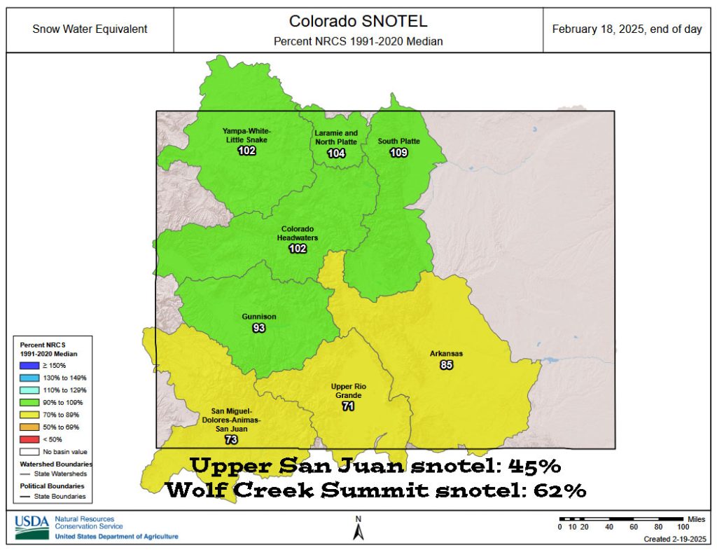
In the last 7 days the Upper San Juan snotel went from 37% to 45% and the Wolf Creek Summit snotel went from 55% to 62%.
Forecast discussion…

There is nothing on radar in our area around noon on Wednesday.
Forecast highlights…
*** A few spotty mountain snowflakes are possible Thursday and Friday afternoons. ***
*** Lots of sun, dry, and warm through the rest of February. ***
Wednesday afternoon through Thursday morning… There will be a lot of sun Wednesday afternoon and then clouds will increase Wednesday night.
Temps… Wednesday night lows will be in the mid-teens to mid-20s.
Winds… Gusts Wednesday afternoon will be 15-20mph.
Thursday afternoon through Friday afternoon… We’ll get a few “scraps” as a weak system moves through northern Colorado. There will be a few spotty snowshowers, mostly over the mountains. The best chance for a few spotty snowflakes is each afternoon.
Snow amounts…
Wolf Creek area: up to 1”
Pagosa area: a few spotty snowflakes
Temps… Thursday highs will be in the mid to high 40s and lows will be in the low teens to low 20s. Friday highs will be in the high 30s to mid-40s and lows will be in the high single digits to mid-teens.
Winds… Thursday afternoon gusts will be 15-20mph. Friday afternoon gusts will be 10-15mph.

Friday night through next Friday… Ridging will build over the desert southwest. We’ll see lots of sun and a warming trend.
Temps…
Friday night lows will be in the high single digits to mid-teens.
Saturday highs will be in the mid-40 to low 50s and lows will be in the mid-teens to low 20s. Sunday highs will be in the low to high 50s and lows will be in the high teens to mid-20s. Monday and Tuesday highs will be in the mid-50s to low 60s and lows will be in the high teens to mid-20s.
Wednesday, Thursday, and Friday highs will be in the low to high 50s and lows will be in the high teens to mid-20s.
Winds… Afternoon peaks will be 10-15mph. Tuesday and Wednesday afternoons windy spots could get gusts to 20mph.
The rest of the 14-day period… The long-range forecast models continue to show the pattern getting more active the first week of March.

The inset shows total snow possible for Wolf Creek. It’s read left to right and times are in Zulu. There’s isn’t much going on until 2/3 Mar. By 6 Mar, 8” of snow is possible for Wolf Creek.
The next post will be on Friday.
– Shawn


