

Prince Charming is a young lab mix looking for a home at the Humane Society of Pagosa Springs. This guy is smart, eager, and affectionate!
Saturday – 25 Jan 2025 – 4:50pm
The past…
At Stevens Field the high temperature on Friday was 37 and as of 3pm on Saturday it was 41. The low this morning was 9.
The peak wind at Stevens Field Friday afternoon was 10mph and on Saturday it was 12mph.
| Average High | Record High / Year | Average Low | Record Low / Year |
| 38 | 55 / 1944 | 3 | -29 / 1938 |
Precipitation summary… There has been no recent measurable precip.
Forecast discussion…

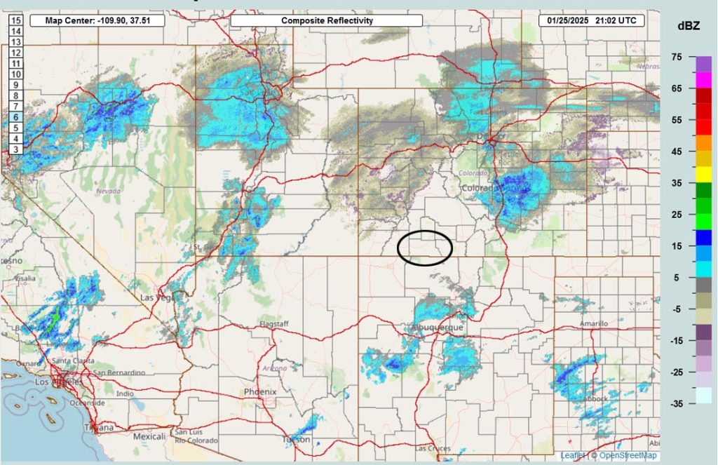
There is no precip in our area.
Forecast highlights…
*** Occasional waves of scattered snowshowers, mostly over the mountains, Saturday evening through Thursday afternoon. ***
*** Another round of snow is possible late next Saturday into next Monday. ***
Yay for a pattern change!
Big picture – Saturday evening through Thursday afternoon … A cut-off low will wobble around the desert southwest region. We’ll see occasional waves of scattered snowshowers, especially Wednesday night and Thursday.
Cut-off lows are difficult to forecast. Much like hurricanes, they move erratically because upper-level steering flow is weak or nonexistent. A “wobble” of just a hundred miles in any direction significantly impacts the outcome.
The easy part of the forecast… We’ll see more clouds and temps near average to slightly above average.
The hard part of the forecast… Timing the precip and precip amounts.
Round 1 Saturday evening to late Sunday evening… The cut-off low will sink south over southern CA. Mid and upper-level moisture is streaming into CO but things aren’t lining up for us. A few spotty snowflakes are possible, mostly over the mountains.
Snow amounts…
Wolf Creek area: up to a half inch
Pagosa area: a snowflake or two
Temps… Saturday night lows will be in the mid-teens to low 20s. Sunday highs will be in the mid 30s to low 40s and lows will be in the low teens to low 20s.
Winds… Afternoon peaks will be around 15mph.

Be careful if you have to travel along the I-25 corridor.
Sunday night through Monday… We’ll have a little bit of a break with a weak chance for a few spotty snowshowers, mostly over the mountains.
Temps… Sunday night lows will be in the low teens to low 20s. Monday highs be in the low to high 40s and lows will be in the high single digits to high teens.
Winds… Afternoon peaks will be around 15mph.
Round 2 – Monday night through Thursday afternoon… The low is expected to move slowly through AZ and NM. The Euro forecast model expects the low to move through the southern part of AZ and NM while the GFS expects it to move through the central part of both states. Euro = less snow while the GFS = more snow.
The best chance for snow is Wednesday afternoon into Thursday afternoon.
Snow amounts…
Wolf Creek area: 3-6”
Pagosa area: 1-3”
Temps… Monday night lows will be in the high single digits to the high teens. Tuesday, Wednesday, and Thursday highs will be in the high 30s to mid-40s and lows will be in the low teens to low 20s.
Winds… Afternoon peaks will be around 15mph.
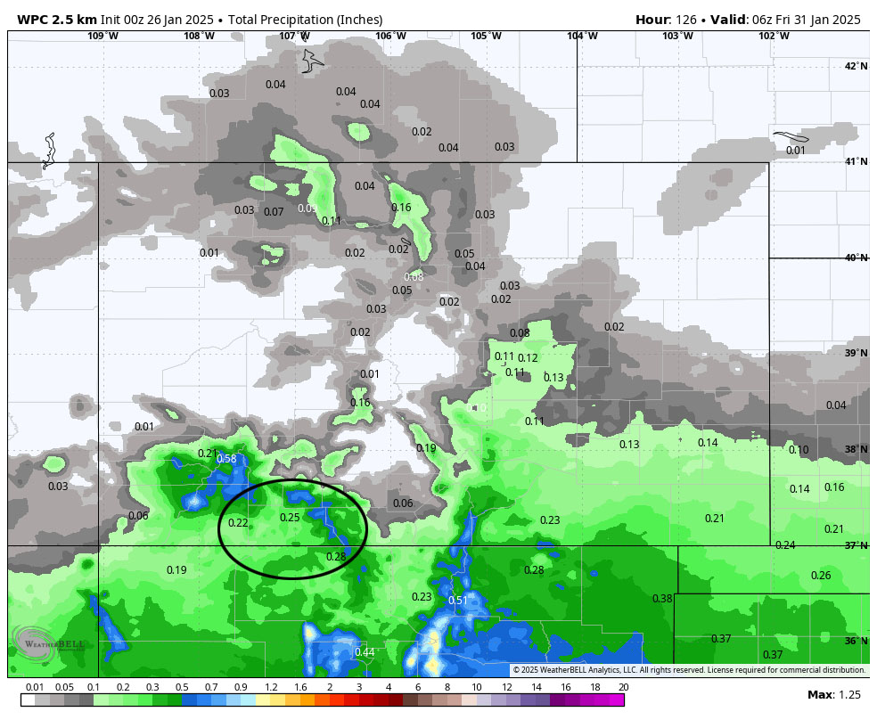
The rest of the 10-day period… The next low-pressure system and another round of snow could happen late next Saturday through next Monday. And then another low-pressure system is possible later next week. Let’s hope things look much more like winter in the next 7-10 days!
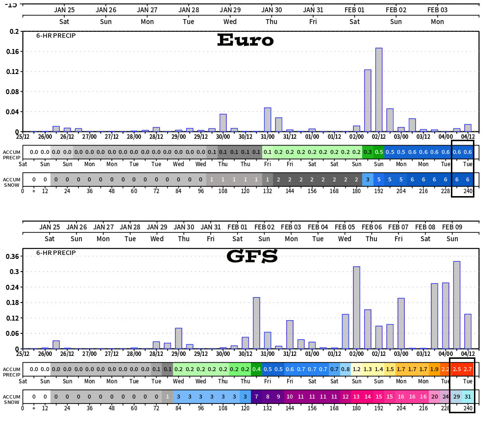
Big picture: Both of these show a chance for precip most of the 10-day period.
Comparisons: The Euro only expects 2” between now and Saturday evening while the GFS expects 11-12” during the same time. For the entire 10-day period, the Euro only expects 6” while the GFS has 31” – huge difference.
Either scenario is possible. These inconsistencies result in low forecast confidence and why we usually avoid forecasting precip amounts beyond 5-7 days.
The ensemble forecasts for this period, which I trust a little more, show 5-10” of snow near Pagosa and 1-2ft near Wolf Creek.
It’s almost time to do your snow dances and wash your cars!
My next post will be on Monday.
– Shawn


