

The spring snow was pretty this morning! – Pic taken 4/27/2024
If images fail to load in the email, please click the title of the post. Thanks!
Saturday – 27 Apr 2024 – 9:30am
The past…
At Stevens Field the high temperature yesterday afternoon was 56 and the low this morning was 33.
The peak wind at the airfield yesterday was 25mph.
| Average High | Record High / Year | Average Low | Record Low / Year |
| 61 | 76/ 1954 | 26 | 11 / 1951 |
Precipitation summary… Finally some precip to report! Based on snotel data, I estimate that Wolf Creek Pass got 3-5” of snow overnight.
Thanks to everyone for your reports and pictures on Facebook!


Forecast discussion…


Forecast highlights…
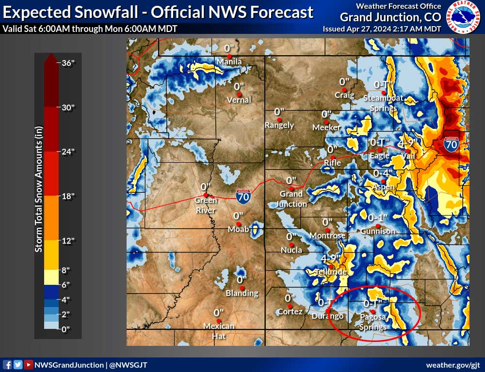
*** A WINTER WEATHER ADVISORY has been issued for the eastern San Juan Mountains above 10,000ft, which includes Wolf Creek Pass. Up to 8” of additional snow is possible to 6am Sunday. ***
*** Wolf Creek Pass will have periods of poor visibility and slick roads through Sunday morning. ***
Rest of Saturday through Sunday… The low-pressure system is spinning near Farmington and will move over our heads later Saturday morning. Our sector of this storm is disorganized with spotty showers.
Timing… It will get more active later this afternoon and into the evening but precip will be hit and miss. Isolated brief periods of heavy precip are possible with scattered showers and a thunderstorm or two. There will be a lull Saturday night into Sunday morning and then we’ll have another round of scattered showers and an isolated thunderstorm or two Sunday afternoon. Precip will be done by Sunday evening.
All types of precip are possible: rain, snow, graupel, and small hail.
Snow levels at 8am Saturday are around 7,300ft, will jump to 8,400ft late Saturday afternoon, drop to 7,600ft by sunrise Sunday, and then jump above 9,000ft Sunday afternoon. Temps will be above freezing so snow will struggle to accumulate.
Additional Snow to sunset Sunday…
Valley below 7,600ft: mostly “rainflakes” – a dusting of snow on cold surfaces
Valley above 7,600ft: Up to 1” on cold surfaces
Mountains: 4-8”
Winds… Saturday and Sunday afternoon gusts will be 15-20mph. Isolated stronger gusts are possible near thunderstorms.
Temps… Highs Saturday will be in the low 40s to low 50s and lows will be in the high 20s to the mid-30s. Highs Sunday will be in the low to high 50s and lows will be in the mid-20s to mid-30s.


Monday through Thursday… Upper-level flow will be flat – west to east. For us that means mostly sunny skies, no precip, and gusty afternoon winds.
Thursday we will see a few more clouds as a system skirts across northern Colorado.
Winds… Afternoon gusts will be around 25mph each day.
Temps… Highs Monday will be in the high 50s to high 60s and lows will be in the high 20s to mid-30s. Tuesday and Wednesday highs will be in the mid-60s to low 70s and lows will be in the high 20s to high 30s. Thursday highs will be in the high 50s to high 60s and lows will be in the mid-20s to mid-30s.
My next post will be tomorrow.
– Shawn


