

Clouds cleared last night and we were treated to another fantastic Pagosa Country sunset – pic taken 1/15/2024
If images fail to load in the email, please click the title of the post. Thanks!
Tuesday – 16 Jan 2024 – 10:00am
The past…
At Stevens Field the high temperature yesterday afternoon was 35. The low temp this morning was missing. Most of the area was in the -5 to 5 range this morning, but the cold spots were near -10. The upper Piedra River bridge had a low of -20!
The peak wind at Stevens Field yesterday afternoon was 22mph.
| Average High | Record High / Year | Average Low | Record Low / Year |
| 38 | 63 / 1944 | 3 | -31 / 1947 |
Precipitation summary… There was no measurable precip in the last 24 hours.
Forecast discussion…

There is nothing on radar in our area this morning.
Forecast Highlights…
*** A few snowflakes are possible Wednesday afternoon and evening. ***
*** Chance for snow Saturday night to Monday afternoon. ***
Tuesday afternoon through Wednesday morning… Ridging will build along the west coast and keep us mostly sunny and dry.
Winds… Peaks will be around 10mph this afternoon.
Temps… Highs Tuesday will be in the high 20s to mid-30s and lows will be around 0 to the low teens. Temps will then warm to near seasonal averages the rest of the week.
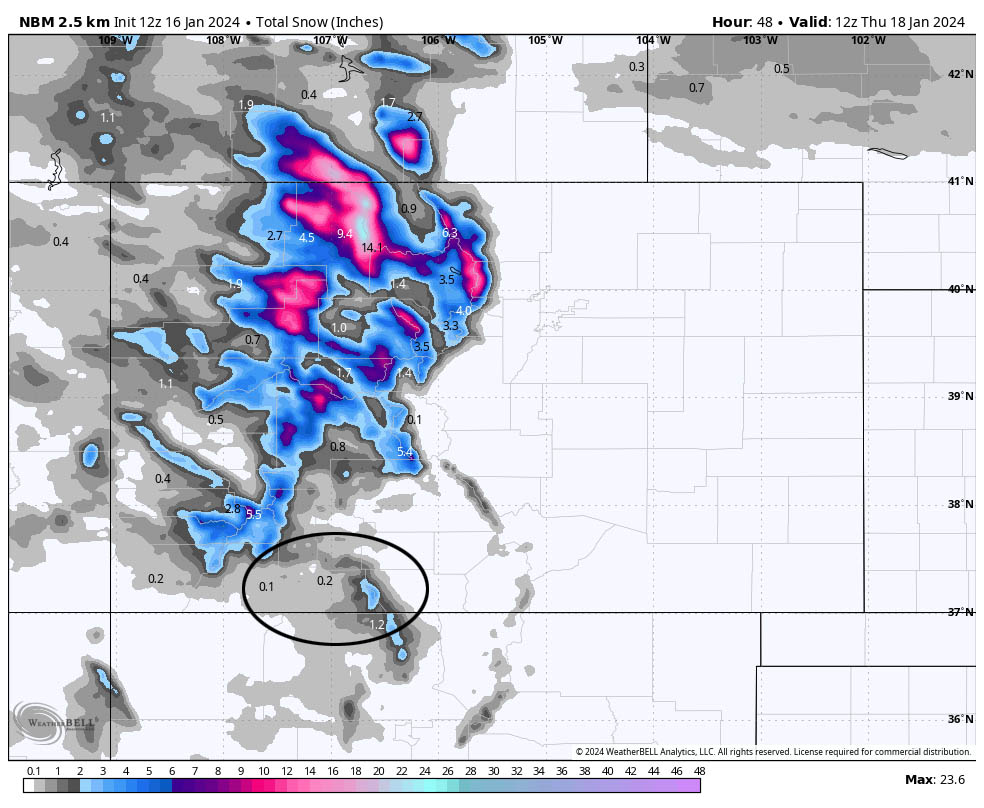
Wednesday afternoon to early Thursday morning… A weak, fast-moving trough with limited moisture will move through Colorado from the northwest. None of this lines up well for us. We’ll see more clouds and a few scattered snowshowers, mostly along The Divide. The best chance for snow is Wednesday afternoon into Wednesday evening.
Snow amounts…
Valley: up to a half inch in the lucky spots
Mountains: up to 2” in the lucky spots
Winds… Peaks will be 10-15mph.
Temps… Highs Wednesday will be in the low to high 30s and lows will be in the high single digits to high teens.
Thursday afternoon to Saturday afternoon… An upper-level ridge will slowly move towards us and keep us dry. The ridge will move over us Friday night and then upper-level southwest flow will push more clouds into our area the rest of Saturday.
Winds… Peaks will around 10mph each afternoon.
Temps… Highs Thursday will be in the mid-30s to low 40s and lows will be in the high single digits to high teens. Highs Friday and Saturday will range from near 40 to the mid-40s. Lows Friday night will be in the low teens to low 20s.
Saturday evening to Monday afternoon… The next system will move through. It will be disorganized, have limited moisture, and a bit warmer.
Timing… The first scattered showers will start over the mountains Saturday afternoon and then over the valley Saturday night. Scattered snowshowers will persist into Monday afternoon.
Snow levels… Starting Saturday afternoon snow levels will be around 8,000ft, drop to 7,000ft by sunrise Sunday, rise to 7,500ft Sunday afternoon, drop to 6,500ft Sunday night, and then rise to 7,300ft Monday afternoon.
Snow amounts…
Valley below 7,500ft: 1-3”
Valley above 7,500ft: 2-4”
Mountains: 6-10”
*** Forecast confidence in the timing and snow amounts is low at this time. I’ll update these as the data gets better. ***
Winds… Peaks will be around 10mph each afternoon.
Temps… Lows Saturday night will be in the low to high 20s. Highs Sunday will be in the mid-30s to around 40 and lows Sunday night will be in the mid-20s to low 30s. Highs Monday will be in the mid-30s to around 40.

Unless something unexpected pops up, my next post will be Thursday afternoon.
– Shawn


3 Responses
Shawn,
An you estimate how much measurable snow we have had in Pagosa Springs since 12/01/23 to present? I have a “rough” estimate of 37” where I live in upper Pagosa Spr8ngs.
Thanks.
Thank you for including Chama…You are our go to weather guy!
Thanks so much Angela! I closely follow ABQ NWS. They do a good job for you guys too!