

A colorful Pagosa Country sunrise over Graham Peak and a sea of fog – pic taken 1/13/2024
If images fail to load in the email, please click the title of the post. Thanks!
Saturday – 13 Jan 2024 – 10:15am
The past…
At Stevens Field the high temperature yesterday afternoon was 19. The low temp this morning was -4. Clouds cleared just long enough this morning to allow temps to drop.
Most locations this morning were in my forecast range of -5 to 5, but like usual this time of year, some spots were above that range and some were below. The cold spots dipped into the -10 to -15 range and the warm spots were around 10 – a 25-degree range in temps. It’ amazing how our terrain plays such a big role in our weather!
The peak wind at Stevens Field yesterday afternoon was 7mph.
| Average High | Record High / Year | Average Low | Record Low / Year |
| 38 | 59 / 1956 | 2 | -42 / 1963 |
Precipitation summary… A few tiny little snowflakes fell in parts of Archuleta County last night. A few CoCoRaHS reports had a trace, but two reports had 0.2”.
Wolf Creek reported 3” of new snow in the last 24 hours.
Forecast discussion…

There is nothing on radar in our region this morning.
Forecast Highlights…
*** Snow tonight into Sunday afternoon. ***
*** A SPECIAL AVALANCHE ADVISORY is in effect for the mountains of Colorado. New snow and winds through the holiday weekend will increase avalanche danger statewide. The most dangerous avalanche conditions will develop Saturday afternoon into Sunday. ***
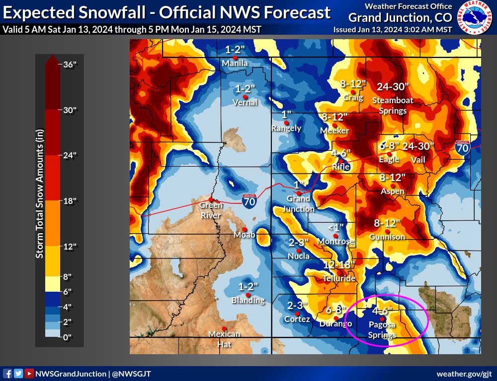
*** A WINTER STORM WARNING has been issued by the Pueblo NWS for the eastern San Juan Mountains, which includes the Wolf Creek area. 6-18” of snow and winds to 50mph are expected. The warning is valid from 5pm Saturday to 5pm Monday. *** Most of this snow will fall Saturday night into Sunday afternoon.
Saturday to Sunday evening… This storm will be moving through the region from the northwest. The northern and central mountains will be favored. We’ll just get scraps.
The best storm energy and moisture will be Saturday night and Sunday morning. Unfortunately upper-level flow will be mostly from the west instead of our more favorable southwest flow. Westerly flow can favor the Chromo and Chama areas, so I’m going to forecast a little more snow in those areas.
Timing… Scattered snowshowers are possible over the mountains all day and will ramp up late this evening. The first few snowshowers in the valley will start in the late evening and then ramp up during the early morning hours. The best chance for snow is early Sunday morning to around noon Sunday. Scattered snowshowers will persist into the afternoon, mostly over the mountains.
Snow amounts…
Pagosa area: 2-5”
Chromo and Chama areas: 5-10”
Mountains: 6-12”
Winds… Peaks will be around 15mph Saturday and Sunday afternoons.
Temps… Highs Saturday will be in the mid-20s to low 30s and lows Saturday night will be in the low teens to low 20s. Highs Sunday will be in the high 20s to mid-30s and lows Sunday night will be in the mid-single digits to mid-teens.
Sunday night to Monday afternoon… Moisture will continue to move through the region from the northwest. Weak pulses of energy could kick up spotty snowshowers, mostly over the mountains.
Snow amounts…
Valley: 0-1”
Mountains: 1-3”
Winds… Gusts Monday afternoon will be 15-20mph.
Temps… Lows Sunday night will be in the mid-single digits to low teens. Highs Monday afternoon will be in the mid-20s to low 30s.

This looks reasonable to me, though I think snowshowers will be hit and miss.
Monday evening through Thursday… Transient ridging will build along the west coast and keep us mostly sunny and dry. A weak trough with limited moisture could push a few more clouds through Wednesday evening into Thursday morning. I don’t expect any snow but I’m keeping an eye on it.
Winds… Peaks will be around 10mph Wednesday and Thursday afternoons.
Temps… Lows Monday night will be negative mid-single digits to around 10. Highs Tuesday will be in the high 20s to mid-30s and lows will be in the low single digits to low teens. Temps will then warm to near seasonal averages. Highs Wednesday and Thursday will be in the mid-30s to low 40s and lows will be in the high single digits to mid-teens.
My next post will be tomorrow.
– Shawn


