
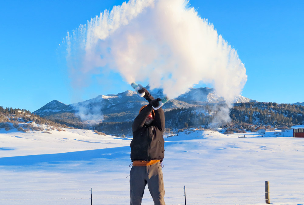
In frigid air, hot water condenses rapidly into tiny droplets and turns into steam. It’s really cool! – pic taken 1/12/2024
If images fail to load in the email, please click the title of the post. Thanks!
Friday – 12 Jan 2024 – 1:00pm
The past…
At Stevens Field the high temperature yesterday afternoon was 26. The low temp this morning was -12. Most locations this morning were in the -5 to -20 range.
*** We had the two coldest locations in Colorado: -33 near the upper Piedra River bridge and -29 in Wildflower! ***
THANKS to everyone for your Facebook reports and temps. It was great seeing people doing the hot water trick!

The peak wind at Stevens Field yesterday afternoon was 12mph. Just north of Turkey Springs, we hit 20mph around sunset and the powdery snow got blown around a bit.
| Average High | Record High / Year | Average Low | Record Low / Year |
| 38 | 60 / 1956 | 2 | -38 / 1963 |
Precipitation summary… It snowed lightly into the afternoon yesterday. Additional snowfall amounts were mostly light, but a couple of spots got more snow than I expected.
Wolf Creek reported 8” in the last 24 hours and storm total of 24”. They were well above my expectations.


Forecast discussion…

There is nothing on radar in our region this afternoon.
Forecast Highlights…
*** A Special Avalanche Advisory is in effect for the mountains of Colorado. New snow and winds through the holiday weekend will increase avalanche danger statewide. The most dangerous avalanche conditions will develop Saturday afternoon into Sunday. ***
*** A few mountain snowshowers tonight. ***
*** Another round of snow Saturday night and Sunday. ***
Friday… A weak trough will move through tonight from the northwest with limited moisture. – not favorable for us. We’ll see a few more clouds and spotty snowshowers, mostly over the mountains. Lucky spots in the valley could get a half inch and 1-3” is possible in the mountains. The best chance for spotty snowshowers is Friday evening into early Saturday morning.
Winds… Peaks will be 15-20mph.
Temps… Highs Friday will be in the high teens to mid-20s. Clouds Friday night should prevent us from getting frigid. Lows will be -5 to +5.

Saturday to Sunday evening… The forecast models are beginning to agree that the weekend storm will be like the one that moved through yesterday.
This storm will be moving through the region from the northwest. The northern and central mountains will be favored. We’ll just get scraps.
The best storm energy and moisture will be Saturday night and Sunday morning. Unfortunately upper-level flow will be mostly from the west instead of our more favorable southwest flow. Unless this system dives a little farther south, it has more potential to be a dud than a decent storm for us.
Snow amounts…
Valley: 2-5”
Mountains: 6-12”
Winds… Peaks will be around 15mph Saturday and Sunday afternoons.
Temps… Highs will be in the mid-20s to low 30s. Lows Saturday night will be in the low teens to low 20s and lows Sunday night will be in the mid-single digits to low teens.

Sunday night to Monday afternoon… Moisture will continue to move through the region from the northwest. Weak pulses of energy could kick up spotty snowshowers, mostly over the mountains.
Snow amounts…
Valley: 0-1”
Mountains: 2-4”
Winds… Gusts Monday afternoon will be 15-20mph.
Temps… Lows Sunday night will be in the mid-single digits to low teens. Highs Monday afternoon will be in the mid-20s to low 30s.

Time for some math. I’m expecting cold temps and a snow ratio around 14:1. So that equals 0.5” of snow for Pagosa, 1” for Chama, 0.1” for Bayfield, and up to 4” (20:1 ratio) in our mountains.
Monday evening through Thursday… Transient ridging will build along the west coast and keep us mostly sunny and dry. A weak trough with limited moisture could push a few more clouds through on Wednesday. I don’t expect any snow but I’m keeping an eye on it.
Winds… Peaks will be around 10mph Wednesday and Thursday afternoons.
Temps… Lows Monday night will be 0 to -15. Highs Tuesday will be in the high 20s to mid-30s and lows will be in the low single digits to low teens. Temps will be near seasonal averages. Highs Wednesday and Thursday will be in the mid-30s to low 40s and lows will be in the high single digits to mid-teens.
My next post will be tomorrow.
– Shawn


2 Responses
Exactly which bridge are you referring to as “the upper Piedra River Bridge?”
Hello Chuck! Off Taylor Lane, about a quarter mile to the northeast of the picnic area on the river.