

A few parting clouds allowed for a peek at Pagosa Peak this morning. © 2023-Mark Langford
Thursday 12-14-2023. 8:45am update.
The past…
At Stevens Field the high yesterday was 38 degrees and the low this morning was 32 degrees. Winds gusted to only 7mph yesterday and our humidity bottomed out at 66% yesterday afternoon.
Precipitation summary: We finally have something to report! Temperatures and elevation made a real difference in snow totals over the past 24hrs, with the highest snow totals at Shawn and Arleen’s place and mine, about a mile north of Hatcher Lake. Wolf Creek Ski area reports 10 inches of snow.


Pagosa Springs historical data for December 14th.
| Average High | Record High / Year | Average Low | Record Low / Year |
| 39 | 57/ 1988 | 3 | -20/ 1949 |
Travel Disclaimer: While we would love to help you make decisions on whether to drive over the pass, plan your trip or predict if planes will be able to take off in Durango on a particular date, we don’t have the resources to do so…plus it puts us in potential legal liability if you go flying off Wolf Creek Pass when we suggested it would be a good day to travel! Please use these two links: New Mexico Road Conditions and Colorado Road Conditions. And this one for Durango Airport flight information.
Current watches and warnings:
For Pagosa Springs:
WINTER WEATHER ADVISORY REMAINS IN EFFECT UNTIL 11 AM MST THIS MORNING ABOVE 6500 FEET… * WHAT…Snow above 6500 feet. Additional snow accumulations of up to 3 inches. * WHERE…Animas River Basin and San Juan River Basin. * WHEN…Until 11 AM MST this morning.
Wolf Creek Pass:
WINTER STORM WARNING REMAINS IN EFFECT UNTIL 11 AM MST THIS MORNING... * WHAT…Heavy snow. Additional snow accumulations of 4 to 8 inches. * WHERE…Eastern San Juan Mountains Above 10000 Feet. * WHEN…Until 11 AM MST Thursday.
Forecast discussion…
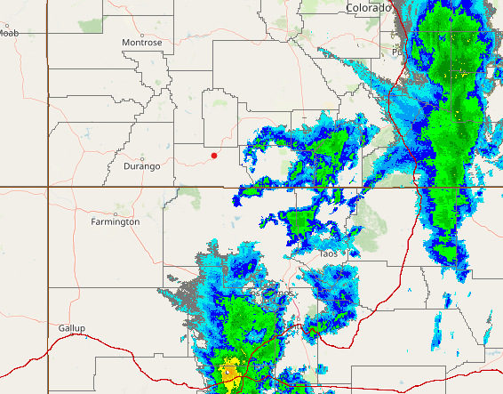
The cut-off low is presently just south of the Four Corners and moving east. Most of the precipitation is ahead of the low, so only a few more showers for us, mainly this morning. Look for mostly cloudy skies today, then clearing tonight. Mostly fair weather for at least the next 5 days, but some of the models are hinting at a possible storm the weekend before Christmas! I’ll have an update on that when I do my next post on Saturday.

5-Day Forecast…
The rest of today: Mostly cloudy with a few snow showers, mainly in the morning. Highs in the upper 30’s to low 40’s. Winds SW 5-10mph.
Friday-Saturday: Mostly sunny with lows in the teens and low 20’s and highs in the low to mid 40’s. Winds SW 5-10mph.
Sunday-Monday: Mostly sunny with lows in the teens and low 20’s and highs in the upper 40’s to low 50’s. Winds SW 5-10mph.
Tuesday: Mostly sunny with lows in the teens and low 20’s and highs in the mid to upper 40’s. Winds SW 5-10mph.
Check out my Pagosa Peak Cam (myearthcam.com) for watching hikers, bikers and of course, the weathe


