

The weather was fantastic up at Wolf Creek yesterday! – Pic taken 12/5/2023 by Todd
If images fail to load in the email, please click the title of the post. Thanks!
Wednesday – 6 Dec 2023 – 10:00am
*** Tonight, at 5:30pm “Ski and Bow Rack, Matt Huber from the CAIC and a member from SAR invite you to a community event to learn and discuss snow safety, avalanche awareness and wilderness preparedness. ***
We hope to see you at Ski and Bow Rack tonight!
The past…
At Stevens Field the high temperature yesterday afternoon was 52. The low this morning was 21.
The peak wind at Stevens Field yesterday afternoon was 5mph.
| Average High | Record High / Year | Average Low | Record Low / Year |
| 42 | 69 / 1906 | 8 | -19 / 1953 |
Precipitation summary… There was no measurable precip reported in the last 24 hours.
Forecast discussion…

There is nothing on radar in our region this morning.
Forecast Highlights…
*** Warm, lots of sun, and dry through Thursday. ***
*** A little snow on Friday ***
Wednesday and Thursday… The ridge will move through our area today leading to lots of sun and warmer than average temps. We’ll see a few more clouds and slightly stronger winds Thursday as the ridge weakens and moves farther to our east, but we’ll stay dry and warm.
Winds… Afternoon peaks will be 5-10mph today. Thursday afternoon peaks will be 10-15mph.
Temps… Wednesday highs will be in the high 40s to mid-50s and lows will be in the mid-teens to mid-20s. Thursday highs will be in the mid-40s to low 50s and lows will be in the high-teens to mid-20s.
Friday to Saturday morning… We’ll get “scraps” as another system slides to our north.
Timing… The first few scattered snowshowers will start over the mountains Friday morning. The best chance for snow is Friday afternoon to Friday evening. Scattered snow showers could linger over the mountains into Saturday morning.
Snow levels… Will be below 6,500ft.
Snow amounts…
Valley: 0-2”
Mountains: 2-5”
Winds… Afternoon gusts will be around 25mph.
Temps… Highs will be in the mid-30s to low 40s and lows Friday night will be in the mid-single digits to mid-teens

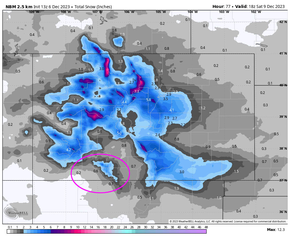
I agree with these slightly lower amounts in our area.
Saturday afternoon through Tuesday… Ridging will build back over the region giving us lots of sun and seasonal temps.
Winds… Afternoon peaks will be in the 10-15mph range.
Temps… Highs Saturday will be in the low to high 30s and lows Saturday night will be 0 to 10. On Sunday highs will be in the mid-30s to low 40s and lows will be in the mid-single digits to mid-teens. Monday and Tuesday highs will be in the high 30s to mid-40s and lows will be in the high single digits to high teens.
My next forecast post will be Friday morning unless there is a significant change.
– Shawn


2 Responses
I deeply appreciate the service you provide for our community. I’ve lived in Pagosa Springs for 20 years, but as older age has crelt up on me, I’ve spent several “recent” winters in Arizona.
I’m now about to return to Pagosa full-time and love “local” weather forecasts.
Upon my return, I will happily contribute to your cause.
Chuck – We’re happy to be helpful to our wonderful community and our visitors. Welcome back to our little paradise!