

It’s going to be a fun weekend in Pagosa Springs!
Friday – 17 Jan 2025 – 4:00pm
The past…
At Stevens Field the high temperature on Thursday was 50 and on Friday it was 39. The low this morning was 10. The cold spots got down to around zero.
The peak wind at Stevens Field Thursday afternoon was 7mph and on Friday it was 16mph.
| Average High | Record High / Year | Average Low | Record Low / Year |
| 38 | 55 / 1976 | 4 | -26 / 1947 |
Precipitation summary… There was no measurable precip in the last 24 hours.
Forecast discussion…

There is nothing on radar in our area.
Forecast highlights…
*** The storm this weekend is a dud. ***
*** Temps 10-15 degrees below average Saturday through Tuesday. ***
*** Potential for a more active pattern starting next weekend. ***
Rest of Friday… There will be a few more clouds tonight as the ridge weakens.
Temps… Friday night lows will be near zero to the mid-teens.
Winds… Friday afternoon winds will peak around 15mph.
Saturday through Monday… The track of the low is shifting a little farther east so our chance for snow has diminished. Snow will favor the Front Range and eastern Colorado.
Snow in our area will be spotty, light, and mostly over the mountains. The best chance for snow is each afternoon.
Snow amounts…
Pagosa area: a dusting in a few lucky spots
Wolf Creek area: up to 1”
Temps… Highs will be in the mid-20s to low 30s and lows will be -10 to 5. The cold spots could get down to -15.
Winds… Saturday afternoon gusts will be 20-25mph. Sunday and Monday afternoon gusts will be 15-20mph.
*** Wolf Creek will be cold… High temps on Saturday will be in the high single digits and winds will gust around 30mph with wind chills in the -10 to -20 range. Sunday high temps will be near 5 with gusts to 20mph with wind chills -10 to -15. Monday highs will be in the mid-single digits with winds gusting 20-25mph with wind chills in the -10 to -15 range. ***
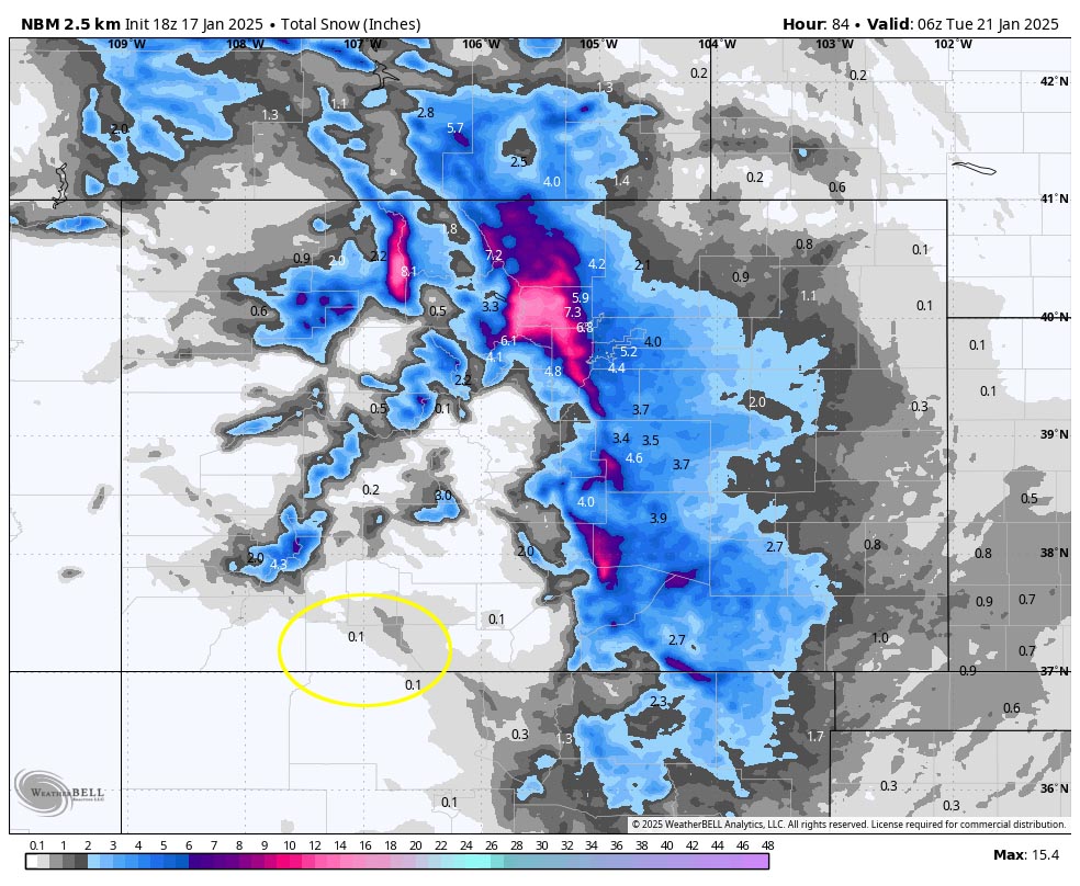
The northern mountains, Front Range, and eastern Colorado will be favored.
Tuesday through Friday… We’ll have mostly dry, upper-level northwest flow. Expect lots of sun with occasional patches of clouds moving through. Temps will remain slightly below average.
Temps… Tuesday highs will be near 30 to the high 30s and lows will be -5 to around 10. Wednesday, Thursday, and Friday highs will be in the mid-30s to low 40s and lows will be in the low single digits to mid-teens.
Winds… Afternoon peaks will be 10-15mph.
The 8-15 day period… My crystal ball is hinting that the west coast ridge will break down around the 25th and the pattern will get more active. It looks promising but I’m not going to get my hopes up yet.
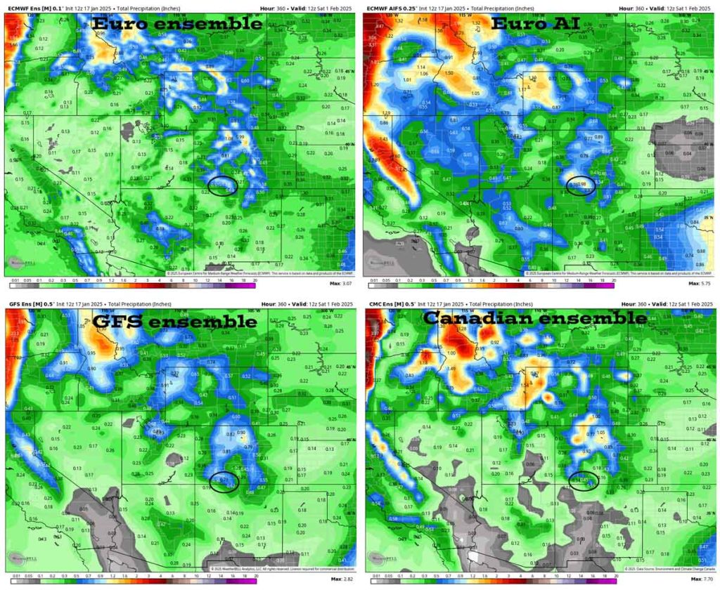
In the upper left the Euro ensemble shows 0.63”.
In the upper right the Euro AI shows 0.98”.
In the bottom left the GFS ensemble shows 0.71”.
In the bottom right the Canadian ensemble shows 0.45”.
My next post will be on Sunday.
– Shawn


