

Arleen was a brave participant in the Penguin Plunge! These hearty souls endured cold air and cold water to raise money for local non-profits. Thanks to the Pagosa Springs Area Chamber of Commerce for organizing Winter Fest, the participants, and everyone who attended! – Pic taken 1/18/2025
Sunday – 19 Jan 2025 – 1:15pm
The past…
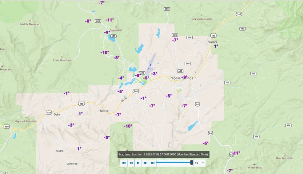
At Stevens Field the high temperature on Saturday was 27 and as of 1pm on Sunday it was 21. The low this morning was -6. The cold spots dipped down to almost -15.
The peak wind at Stevens Field Saturday afternoon was 30mph and as of 1pm on Sunday it was 6mph.
| Average High | Record High / Year | Average Low | Record Low / Year |
| 38 | 54 / 1954 | 3 | -33 / 1943 |
Precipitation summary… Wolf Creek reported 1” of new snow. There has been no recent measurable precip in the Pagosa Springs area.
Forecast discussion…
There is nothing on radar in our area.
Forecast highlights…
*** A few mountain snowflakes Monday afternoon. ***
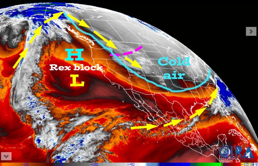
*** Temps 10 to 15 degrees below average through Tuesday morning. ***
*** The Grand Junction NWS has issued an EXTREME COLD WATCH for the Southwest San Juan Mountains from Monday evening through Tuesday morning. Wind chills down to -35 are possible. *** This does not include Pagosa Springs.
*** Lots of sun and a warming trend Tuesday afternoon through Friday. ***
*** Potential for snow Saturday night through Monday morning. ***
Rest of Sunday through Monday… The first trough moved through Saturday afternoon. The second trough will move through Monday afternoon. Limited moisture and a northwest trajectory mean the Pagosa area will be lucky to see a few snowflakes. Lucky spots in our mountains could get up to 1” of snow.
Temps… Highs will be in the low to high 20s and lows will be -10 to 5. The cold spots could get down to -15.
Winds… Sunday and Monday afternoon gusts will be 15-20mph.
*** Wolf Creek will be cold… Sunday high temps will be near 5 with gusts to 20mph and wind chills -10 to -20. Monday highs will be in the mid-single digits with winds gusting 20-25mph with wind chills in the -10 to -20 range. ***

Tuesday through Saturday afternoon… We’ll have mostly dry, upper-level northwest flow. Expect lots of sun with occasional patches of clouds moving through. Temps will warm to near average by Wednesday.
Clouds will increase Saturday ahead of the next low-pressure system.
Temps… Tuesday highs will be in the high 20s to mid-30s and lows will be -5 to around 10. Wednesday, Thursday, and Friday highs will be in the mid-30s to low 40s and lows will be in the low single digits to mid-teens. Saturday highs will be in the high 30s to mid-40s and lows will be in the low teens to low 20s.
Winds… Tuesday through Friday afternoon peaks will be 10-15mph. Saturday afternoon gusts will be 15-25mph.
Saturday night through Monday morning? … The next low-pressure system is expected to cut-off and move slowly through the desert southwest region. There is still a lot of uncertainty with the track, timing, and precip amounts.
Today’s round of forecast models ranges from a dusting of snow from the Euro and Canadian models to a high of 9” from the GFS – go GFS! I’ll include a rough first guess snow forecast in my next post.
The 8-15 day period… After next weekend’s low-pressure system, our nemesis, the west coast ridge, wants to take over again – ugh.
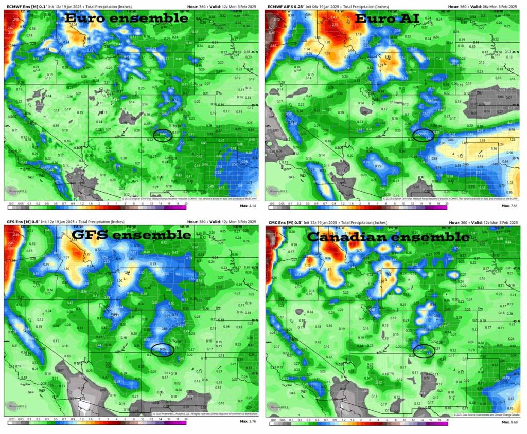
In the upper left the Euro ensemble shows 0.44”.
In the upper right the Euro AI shows 0.61”.
In the bottom left the GFS ensemble shows 0.86”.
In the bottom right the Canadian ensemble shows 0.46”.
My next post will be on Tuesday.
– Shawn


