
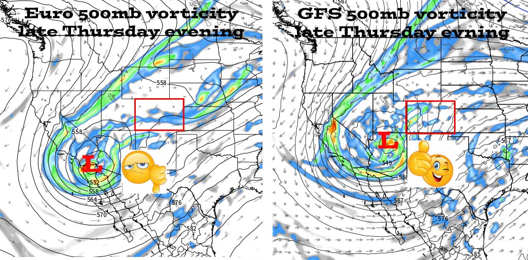
Battle of the forecast models – Go GFS!
If images fail to load in the email, please click the title of the post. Thanks!
Monday – 11 Mar 2024 – 10:00am
The past…
At Stevens Field the high temperature yesterday afternoon was 51 and the low this morning was 23.
The peak wind at the airfield was 9mph.
| Average High | Record High / Year | Average Low | Record Low / Year |
| 47 | 72 / 1989 | 15 | -8 / 1948 |
Precipitation summary… There has been no recent measurable precip.
Forecast discussion…

There is nothing on radar in our region this morning.
Forecast highlights…
*** A slow-moving cut-off low will keep us unsettled Tuesday night into Saturday. ***
*** Travel in the mountains or to the Front Range will be treacherous Wednesday night through Friday. ***
Rest of Monday through Tuesday evening… Upper-level flow is flat – west to east. A weak trough could kick up a spotty shower over the mountains Monday evening.
Clouds will increase Tuesday afternoon ahead of the next system. A shower or two could pop up over the mountains.
The lucky spots in the mountains could get an inch of snow.
Winds… Monday afternoon: 15-20mph. Tuesday afternoon: 10-20mph.
Temps… Highs will be in the mid-40s to mid-50s and lows will be in the high teens to high 20s.
Tuesday night into Saturday… The next system will move through. It will come in waves with the first trough moving through on Wednesday and then a cut-off low spinning over AZ Thursday into Saturday.
Forecast concerns… 1. Transition season (spring) is beginning. Forecast models struggle with transition seasons. 2. Forecast models also struggle with cut-off lows. They are cut-off from upper-level steering flow and wobble around, similar to hurricanes. A hundred-mile “wobble” in any direction significantly impacts the forecast. 3. Daytime temps will be in the high 30s to mid-40s so snow will be slow to accumulate.
Snow amounts…
Valley below 7,500ft: 2-4”
Valley above 7,500ft: 4-8”
Mountains: 14-22”
Our best chance for snow is Thursday night and Friday. An isolated thunderstorm is possible Wednesday and Thursday afternoons.
*** There is still a lot of uncertainty with this system. I will adjust timing and snow amounts as the data gets better. ***
Winds… Wednesday afternoon: 15-20mph – the windy spots could hit 25mph. Thursday afternoon: 15-20mph. Friday and Saturday afternoons: 10-15mph.
Temps… Lows Tuesday night will be in the mid-20s to low 30s. Highs will be near 40 to the mid-40s and lows will be in the low to high 20s.

This is a good example of how forecast models can vary significantly with cut-off lows. The Euro on the left expects the low to be over the lower Colorado River basin while the GFS on the right expects it to be over north-central AZ.
If you want snow, cheer for the GFS!

Wednesday 6am shows a dusting in the Pagosa area and 1-2” near Wolf Creek Pass.
Thursday 6am shows 0.90” near Pagosa and 3-5” near Wolf Creek Pass.
Friday 6am shows 2.5” near Pagosa and 10-15” near Wolf Creek Pass.
Saturday 6am shows 4.4” near Pagosa and 16-22” near Wolf Creek Pass.
NOTE: Travel through the mountains or to the Front Range will be treacherous Wednesday night through Thursday.
Unless there is a significant change to the forecast, my next post will be on Wednesday.
– Shawn


