

Before the snowshowers started yesterday up at Wolf Creek – Pic taken 3/7/2024
If images fail to load in the email, please click the title of the post. Thanks!
Friday – 8 Mar 2024 – 10:00am
The past…
At Stevens Field the high temperature yesterday afternoon was 44 and the low this morning was 26.
The peak wind at the airfield was 24mph. The peak gust at Lobo Overlook yesterday was 26mph. Current conditions at 9:15am at Lobo Overlook: Temp is 16 and winds are out of the north-northeast at 6mph resulting in a wind chill of 7.
| Average High | Record High / Year | Average Low | Record Low / Year |
| 47 | 66 / 1962 | 12 | -14 / 1931 |
Precipitation summary… Spotty showers hit parts of the county yesterday but precip amounts were light. Wolf Creek reported 2” of new snow this morning.

Forecast discussion…


Forecast highlights…
*** Showers and maybe even a thunderstorm Friday afternoon into Saturday morning. ***
*** The Pueblo NWS has issued a WINTER WEATHER ADVISORY for the eastern San Juan Mountains above 10,000ft for 5-10” of snow valid until 11pm Friday. This includes Wolf Creek Pass. ***
*** Daylight savings time starts Saturday night. Remember to “spring forward” one hour. ***
Rest of Friday through Saturday afternoon… A trough will move through from the north Friday evening. It has decent moisture and storm energy, but a northly trajectory is not favorable for us.
Precip will be convective. What does that mean? Showers will be scattered. They start and stop abruptly, change intensity quickly, and impact small areas. One spot could get a quick 2” of snow while another spot just a mile away hardly gets anything. In other words, we’re playing the snow lottery.
Timing… Showers will ramp up Friday afternoon. An isolated thunderstorm or two is also possible. Showers will taper off early Saturday morning but could persist a little longer in the mountains.
Snow amounts… Temps in the valley will be above freezing so snow will struggle to accumulate. All types of precip are possible: rain/snow/graupel/small hail.
Valley: 0-3”
Chama area: 3-7”
Mountains: 5-10”
Winds… Afternoon peaks will be 10-20mph.
Temps… Highs Friday, and Saturday will be in the high 30s to high 40s. Lows Friday night will be in the high teens to high 20s. Lows Saturday night will be in the low teens to low 20s.

CHAMA – The high resolution models expect you guys to do pretty good with this system. An extreme example: The NAM high resolution forecast model thinks the Chama area could see around 16”! I don’t buy it but there could be some up-side surprise.
Saturday night through Tuesday afternoon… Sunday a transitory ridge will dry us out and give us lots of sun.
Monday and Tuesday the ridge will shift to our east and upper-level flow will be west to east. A weak trough could kick up a few scattered showers over the mountains Monday afternoon.
Clouds will increase Tuesday afternoon ahead of the next system. A shower or two could pop up over the mountains.
The lucky spots in the mountains could get an inch of snow.
Winds… Sunday afternoon: 10-15mph. Monday afternoon: 15-20mph – the windy spots could hit 25mph. Tuesday afternoon: 10-20mph.
Temps… Highs will be in the mid-40s to mid-50s and lows will be in the low teens to low 20s.
Tuesday night into Friday morning… The next system will move through. It will come in waves with the best chance for precip on Thursday. I’ll tackle precip amounts in tomorrow’s post.
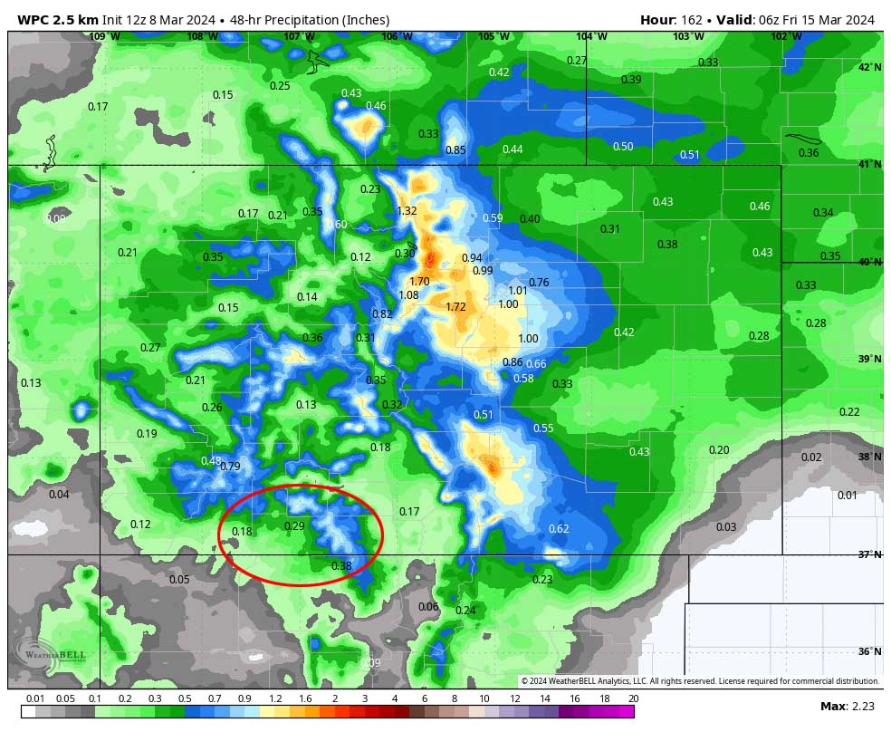
There is a wide range of precip amounts from the various forecast models. Right now, this looks reasonable to me. The challenging part will be trying to figure out how much of this precip will fall as snow.
My next post will be Saturday morning.
– Shawn


