

That’s a happy pup! – Pic taken 23 Feb 2024
If images fail to load in the email, please click the title of the post. Thanks!
Saturday – 24 Feb 2024 – 9:00am
The past…
At Stevens Field the high temperature yesterday afternoon was 47 and the low this morning was 17.
The peak wind at Stevens Field yesterday afternoon was 8mph.
| Average High | Record High / Year | Average Low | Record Low / Year |
| 44 | 60 / 1981 | 10 | -25 / 1909 |
Precipitation summary… There was no measurable precip in the last 24 hours.
Forecast discussion…

There is nothing on radar in our area this morning.
Forecast highlights…
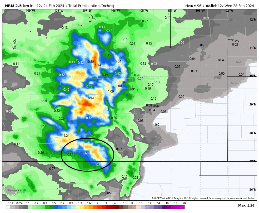
*** Things are lining up for a potentially strong storm Monday and Tuesday. ***
*** Concerns: 1. Strong winds and heavy wet snow could lead to spotty power outages Tuesday. 2. In the valley, warm temps and rain could lead to isolated flooding and rising streams. 3. Occasional blizzard-like conditions are possible early Tuesday morning into Tuesday afternoon, especially above 7,500ft. ***

Rest of Saturday through Sunday evening… The ridge will slowly move to our east. Clouds and winds will gradually increase.
Winds… Peaks Saturday afternoon will be 10-15mph. Peaks Sunday afternoon will be 15-20mph.
Temps… Highs Saturday and Sunday will be in the mid-40s to mid-50s. Lows Saturday night will be in the high teens to high 20s. Lows Sunday night will be in the high 20s to mid-30s.
Sunday night through Tuesday… Things are lining up for an interesting storm. A strong jet stream will set up Monday pushing warm air and moisture into the region. Tuesday a strong system with colder air will move through the region from the northwest.
Timing… The first scattered showers will start over the mountains late Sunday evening and over the valley early Monday morning. The best chance for precip is Monday morning to Tuesday afternoon. Isolated thundersnow is possible on Tuesday. Scattered showers will linger into early Wednesday morning, mostly over the mountains.
Snow levels… Sunday night through Monday evening there will be rain below 8,000ft and a rain/snow mix 8,000ft to 8,500ft. Monday night snow levels will gradually lower to around 7,200ft. Tuesday snow levels will bounce around between 6,500ft and 7,000ft. Temps will be above freezing so snow will struggle to accumulate.
Snow amounts…
Valley below 7,900ft: 1-3”
Valley above 7,900ft: 3-6”
Mountains above 9,000ft: 16-22”
Winds… *** Gusts Monday afternoon to late Tuesday afternoon will be 35-45mph. Winds will gust 60-70mph in the mountains. ***
Temps… Highs Monday will be in the low to high 40s and lows Monday night will be in the high 20s to mid-30s. Highs Tuesday will be in the mid to high 30s and lows Tuesday night will be in the low-single digits to mid-teens.


Wednesday through Friday… Ridging will build over the region and give us lots of sun. Temps Wednesday will be below average and then temps will be near average Thursday and Friday.
Winds… Afternoon peaks will be 10-15mph.
Temps… Highs Wednesday will be in the high 30s to mid-40s and lows will Wednesday night will be in the mid-single digits to mid-teens. Highs Thursday and Friday will be in the mid-40s to low 50s and lows will be in the low teens to low 20s.
My next post will be tomorrow.
– Shawn


2 Responses
Over breakfast at Cafe Colorado, I mentioned the latest snotel report showed the SW CO area at 93% of normal. I was immediately hit with pushback from locals with more tenure here than me. Are the valley areas trailing the peaks significantly in snowfall this averages this year.
Rodney – That’s not easy to answer because snotel data in our area is only in higher elevations. I think we’re slightly below average above 8,000ft and quite a bit below average below that.