

Full moon about to set behind Middle Mountain – Pic taken 25 Feb 2024
If images fail to load in the email, please click the title of the post. Thanks!
Sunday – 25 Feb 2024 – 9:45am
The past…
At Stevens Field the high temperature yesterday afternoon was 48 and the low this morning was 20.
The peak wind at Stevens Field yesterday afternoon was 9mph.
| Average High | Record High / Year | Average Low | Record Low / Year |
| 44 | 68 / 1986 | 10 | -15 / 1909 |
Precipitation summary… There was no measurable precip in the last 24 hours.
Forecast discussion…

There is nothing on radar in our area this morning.
Forecast highlights…
*** The Pueblo NWS has issued a WINTER STORM WATCH for the eastern San Juan Mountains above 10,000ft for up to 30” of snow and winds gusting to 85mph late Sunday night through Tuesday evening. ***
*** My concerns: 1. Strong winds and heavy wet snow could lead to spotty power outages Tuesday. 2. In the valley, warm temps and rain could lead to isolated flooding and rising streams. 3. Occasional blizzard-like conditions are possible early Tuesday morning into early Tuesday afternoon, especially above 7,500ft. ***

Go to https://pagosaweather.org/2024/02/21/snow-dance-contest/ for details. ***
Rest of Sunday… The ridge will slowly move to our east. Clouds and winds will gradually increase.
Winds… Peaks Sunday afternoon will be 15-20mph.
Temps… Highs Sunday will be in the mid-40s to mid-50s. Lows Sunday night will be in the high 20s to mid-30s.
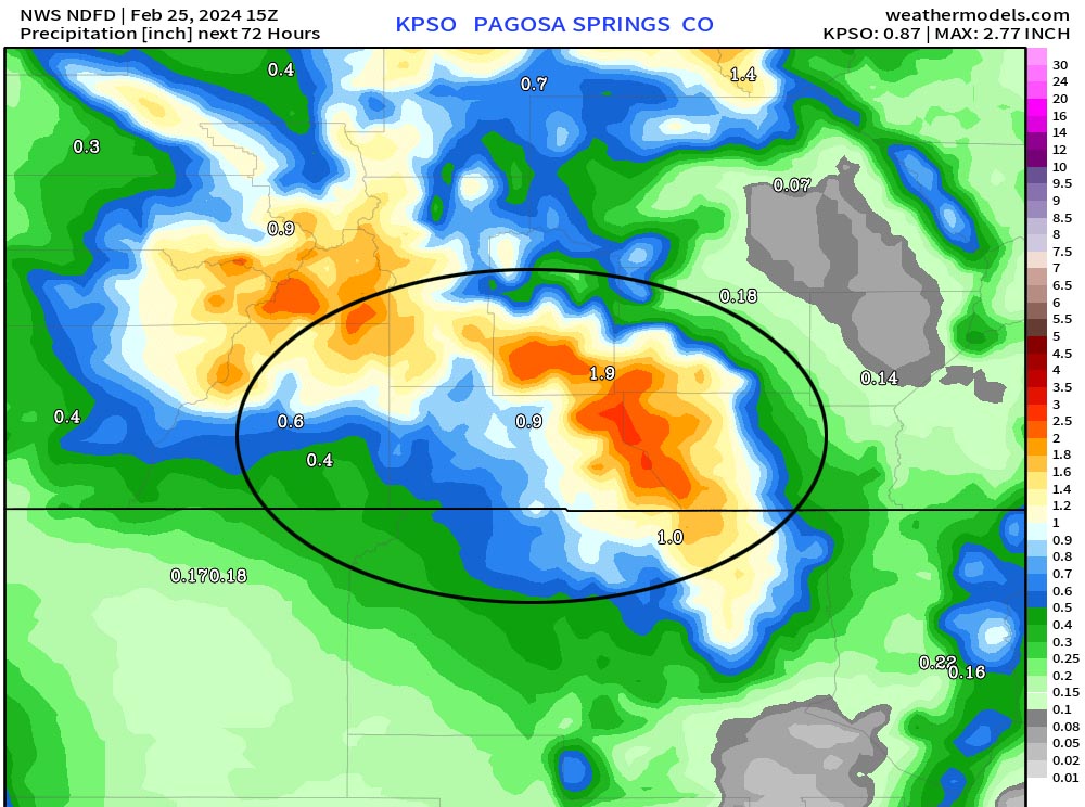
Sunday night through Tuesday… Things are lining up for an interesting storm. A strong jet stream will set up Monday and push warm air and moisture into the region. Tuesday a strong system with colder air will move through the region from the northwest.
Timing… The first scattered showers will start over the mountains late Sunday evening and over the valley early Monday morning. Monday morning into early Monday evening precip will fall on and off in the valley and steadily in the mountains. Late Monday evening into early Tuesday afternoon precip will fall the heaviest. Occasional thundersnow is also possible. Scattered showers will taper off quickly in the valley Tuesday afternoon but will linger over the mountains into Tuesday night.
Snow levels… Sunday night through Monday evening there will be rain below 8,000ft and a rain/snow mix 8,000ft to 8,500ft. Monday night snow levels will gradually lower to around 7,200ft. Tuesday snow levels will bounce around between 6,500ft and 7,000ft. Temps will be above freezing so snow will struggle to accumulate.
Snow amounts…
Valley below 7,900ft: 1-3”
Valley above 7,900ft: 3-7”
Mountains above 9,000ft: 20-30”
Winds… *** Gusts Monday afternoon to early Tuesday morning will be 30-35mph. Early Tuesday morning to Tuesday afternoon gusts will be 35-50mph. In the mountains winds will gust 60-80mph. ***
Temps… Highs Monday will be in the low to high 40s and lows Monday night will be in the high 20s to mid-30s. Highs Tuesday will be in the mid to high 30s and lows Tuesday night will be near zero to the mid-teens.


The stripe of dark blue and dark purple runs along the mountains above 7,900ft. For Wolf Creek Pass 25” is indicated with up to 36” along the higher peaks. The looks reasonable to me but there is a lot of variance that hinges on when snow levels drop and the amount of moisture.

The NBM shows winds 40mph our higher 2am Tuesday to 4pm Tuesday.

Strong winds aloft support gusty winds on the surface and add “fuel” in the form of mixing and lift to enhance precip.
Wednesday through Friday… Ridging will build over the region and give us lots of sun. Temps Wednesday will be below average and then temps will be near average Thursday and Friday.
Winds… Afternoon peaks will be 10-15mph.
Temps… Highs Wednesday will be in the mid-30s to mid-40s and lows will Wednesday night will be in the mid-single digits to mid-teens. Highs Thursday and Friday will be in the mid-40s to low 50s and lows will be in the low teens to low 20s.
Good news… I’m tracking two more systems – one around 3-4 Mar and another around 8-9 Mar.
My next post will be tomorrow.
– Shawn


4 Responses
You and Arlene are doing great! Thanks for having such accurate weather information!
Andy – thanks for the great feedback!
I really like the colored arrows and lines showing direction of fronts etc. that you superimpose on the weather maps. They make it so much more understandable.
Alice – thanks for the great feedback. We’ll keep that in mind for future posts.