

Snow on the Grinch before and after – pics taken 3 and 8 Jan 2024
If images fail to load in the email, please click the title of the post. Thanks!
Monday – 8 Jan 2024 – 2:30pm
The past…
At Stevens Field the high temperature yesterday afternoon was 28. The low this morning was -1. The cold spots were the upper Piedra bridge at -11 and -8 on Saddle Circle near Hatcher Lake. Most areas were in the low to high positive single digits.
The peak wind at Stevens Field yesterday afternoon was 10mph. In O’Neal Park we had a few gusts to 15mph that blew the snow around a bit.
| Average High | Record High / Year | Average Low | Record Low / Year |
| 37 | 57 / 1956 | -2 | -30 / 1913 |
Precipitation summary… Impressive storm! We got a bunch of reports and pictures – thanks!
Wolf Creek reported 21” in the last 24 hours and 29” for the storm total.


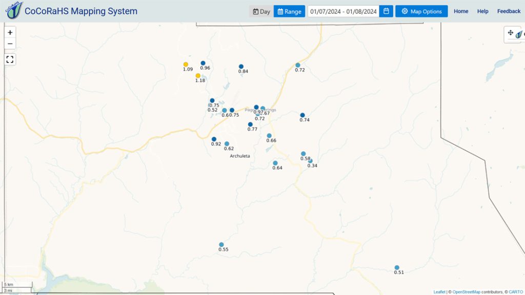

Why the big difference? It’s mostly due to elevation. The two highest snow depth reports are near 8,000ft elevation.
Forecast discussion…

There is nothing on radar in our region this afternoon.
Forecast Highlights…
*** Avalanche danger is rated “considerable”. ***
*** More snow Wednesday evening to Thursday afternoon. ***
Monday through Wednesday morning… Transient ridging will give us a break so we can dig ourselves out. We’ll see quite a bit of sun with occasional patches of clouds. Temps will be 5 to 10 degrees below average.
Winds… Monday afternoon winds will peak in the 15-20mph range. *** The windy spots could see some drifting snow Monday afternoon. *** Tuesday afternoon wind will peak around 10mph.
Temps… Highs will be in the mid-20s to low 30s. Lows will be 0 to -10.
Wednesday afternoon to Thursday evening… The next system will move through. It won’t be organized and will lack moisture so snow amounts will be low.
Timing… Scattered snowshowers will start over the mountains Wednesday afternoon and over the valley in the evening. The best chance for snow is Wednesday night into Thursday morning. Snowshowers will taper off in the valley Thursday afternoon but will linger over the mountains into Thursday evening.
Snow amounts:
Valley: 2-5”
Mountains: 4-8”
Winds… Wednesday peaks will be 15-20mph. *** Watch for drifting snow Wednesday afternoon. *** Thursday peaks will be around 15mph.
Temps… Wednesday highs will be in the mid-20s to around 30 and lows will be in the high single digits to high teens. Thursday highs will be in the low to high 20s and lows Thursday night will be 0 to -15.

Thursday night to Friday night… We’ll get a brief break between storms. Expect quite a few clouds and scattered snowshowers, mostly over the mountains. Lucky spots in the valley could get an inch of new snow and 1-3” is possible in the mountains.
Winds… Peaks will be around 15mph.
Temps… Highs Friday will be in the high teens to mid-20s, and lows Friday night will be -5 to +5.
Saturday into Monday morning… The next storm is trying to get its act together. As of today, it looks like the best storm energy and moisture will miss us to the north and we’ll get scraps, but forecast confidence is low. I’ll tackle this one in Tuesday’s post.

My next post will be tomorrow.
– Shawn


