

It was a glorious sunset last night in O’Neal Park. The dust that enhanced the colors was the only good thing about the winds. Picture taken May 19th. (select title of post to see photo).
Wednesday – 20 May 2026 – 7:00pm
Rainshowers to start the week!
The past…
Stevens Field Observations
Tuesday: High: 63, Low: 32, Peak wind: 29mph
Wednesday: High: 64, Low: 46, Peak wind: 29mph
Clouds overnight kept our minimum temperatures up.
| Average High | Record High / Year | Average Low | Record Low / Year |
| 70 | 80 / 1961 | 32 | 12 / 1940 |
Precipitation summary… Area in southeast Archuleta county and down Hwy 84 saw a few rainshowers yesterday. Robyn in Chromo recorded .05″. Wolf Creek had .10″ of rain or about 1″ of snow.

Current satellite and radar…
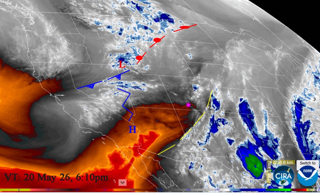
Satellite at 6:10pm on Wednesday: Still under the influence of the upper level trough and its associated winds. A weak frontal system is to the north over Idaho/Wyoming. It will move into northern Colorado on Thursday but won’t impact us other than with afternoon winds. A weak migratory ridge is to the west and will move through our area over the weekend.

Radar at 5:46pm Tuesday – Long wave trough is set up over the Rockies but lacking energy and moisture in our area; only winds. Precipitation is well to our south and to our east.
Forecast highlights…
*** Unsettled weather for the weekend. ***
***Better chance of rain showers and thunderstorms starting Monday into Tuesday.***
Forecast details…
Rest of Wednesday through the weekend… Most of this period will be dry with partly cloudy skies and lots of sun, with a slight chance for a spotty afternoon/evening shower or thunderstorm over the weekend especially in the mountains. Breezy afternoons will persist.
Temps…
Highs will be mid 60s to Lo 70s through Saturday. Sunday will be warmer with highs into the mid 70s to near 80. Lows will be in the low 30s to upper 30s.
Winds…
Afternoon wind gusts to 25mph in the Pagosa area and 30-40mph in the high country through Friday.
Over the weekend, afternoon gusts will be around 15mph in the Pagosa area and around 15-25mph in the high country.
Monday into Tuesday the 26th
An area of low pressure will sink into our southwest lining up perfectly to start giving us showers accompanied by thunderstorms starting Monday afternoon into late on Tuesday.
Clouds will increase throughout the day on Monday. Tuesday will be Mostly Cloudy to Cloudy.
Temps.. Monday highs will be lo 70s to upper 70s. Overnight lows will be upper-30s. Tuesday will be cooler with high temps in the 60s.
Winds… Afternoon gusts will be 20mph in the Pagosa area and 30 mph in the high country.
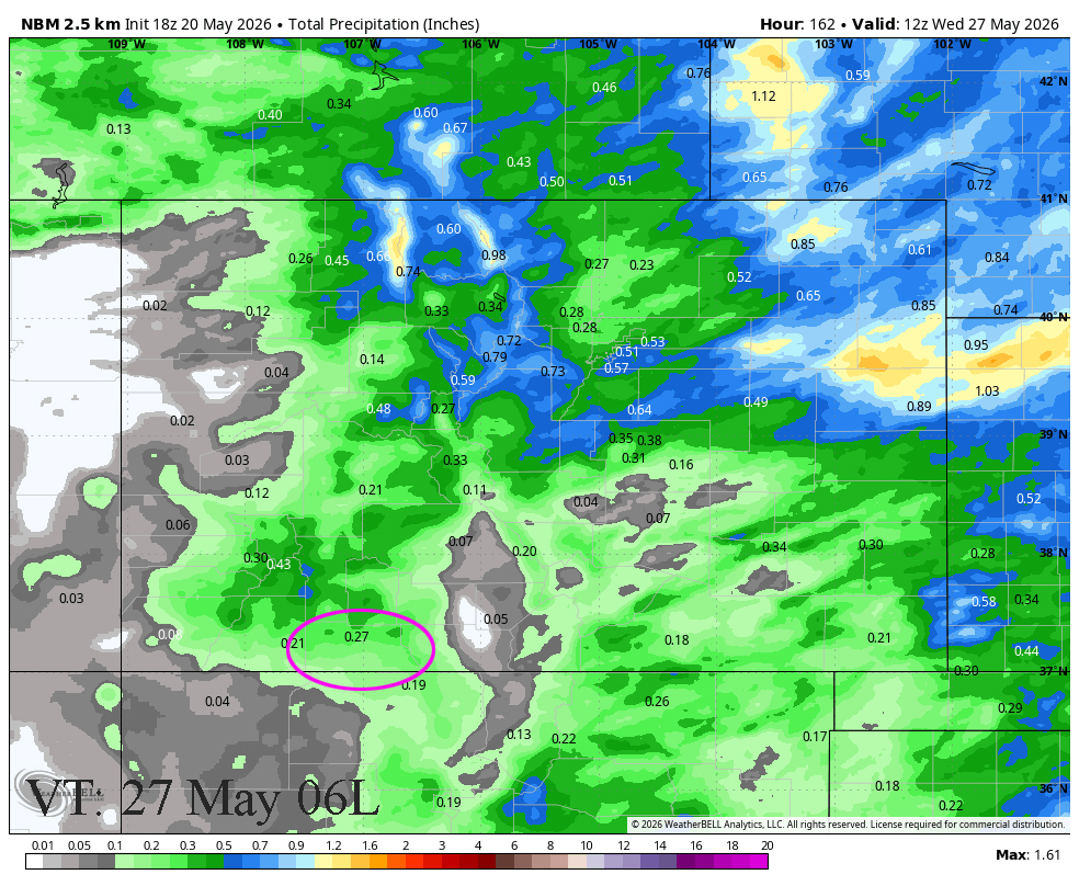
7 Day NBM precip to next Wednesday at 6:00am shows 0.27” near Pagosa and up to 0.60” in our mountains. Most of this will fall Monday afternoon into Tuesday.
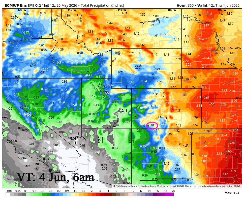
2 week outlook to 4 Jun… There will be a little more moisture and more instability so we will see hit and miss afternoon showers and thunderstorms. The MJO is moving into our area after the 25th and will enhance activity for the end of the month in the beginning of June before things dry out again.
The Euro is showing .91″ to June 4th at 6am while the GFS is showing 1.09″. Both models have been trending down slightly.

My next post will be Saturday.
– Arleen


