

High country meadows are turning green. (click on title of post to see image)
Thursday – 19 Mar 2026 – 5:00pm
Tomorrow at 8:46am is the exact moment of the Equinox. It symbolizes the first day of Spring. The first day of Meteorological Spring is the first of March. But in the high country in locations above 8,000 feet, spring does not arrive till after the first of April. This year with the unusually warm temperatures, it looks like spring with sprigs of green grass popping up and Spring Beauties and even daffodils blooming.
The past…
Stevens Field Observations
* Wednesday: High: High: 74, Low: 30, Peak wind: 21mph
* Thursday: High: 75, Low: 28, Peak wind: 20mph
* Broke March record high temperature of 73 set in in 1907 and 1940.
Winner of 75 degree contest will be announced later tonight.
| Average High | Record High / Year | Average Low | Record Low / Year |
| 52 | 73 / 1907 | 16 | -4 / 1917 |
Precipitation summary… There has been no recent measurable precip.
Current satellite and radar…

Satellite: The ugly ridge is firmly in place to our west. Warm dry air is feeding into it, so it will stay strong over the next few days. Most moisture has been cut off so we have extreme blue and clear skies with only an occasional cirrus wisps.
Looking way upstream, minor troughs are impacting the ridge to the west. By Sunday, those troughs will beat the ridge down, flattening it. This will give us slightly coolers temps and those mid level and high level clouds for pretty sunrises and sunsets. Unfortunately, no precipitation this week.
Radar: There is nothing on radar in our area Tuesday afternoon. The only upstream precipitation is way up in Washington.
Forecast highlights…
*** T-shirt Weather – record high temps this week. ***
Forecast details…
Thursday through Saturday (21 Mar)… The “hell high” is over the southwest US. It will be parked over southern CA/AZ through Saturday. The storm track will be well to our north.
We’ll have mostly Clear skies and remain dry.
Temps: Temps will be 25 degrees above average through Saturday. Record high temps are likely. Record high for today, Thursday is 67, Friday is 68, and Saturday record high is 69.
*** Note: Our record high for the month of March was 73 set on 19 Mar 1907, 23 Mar 1940, and 25 Mar 1940. ***
Temps will be Low 70s to upper 70s. The mountains could see highs in the mid-50s, while Arboles could be in the low 80s.
Lows will be in the mid 20s to the mid 30s.
Winds: Today, Thursday through Saturday, each afternoon gusts will be 10-18mph in the Pagosa Springs area and around 25mph in the high country.
Sunday through Thursday (22 to 26 Mar)… The “hell high” will weaken, shift east and flatten. We’ll have a dry, westerly flow. Skies will be partly to mostly cloudy with mid and high level clouds making for pretty sunrises and sunsets.
Temps: High temps will be 5 to 10 degrees cooler, but still well above average! “Hell High” will rebound by Wednesday. Highs will be in the mid 60s to low 70s Sunday through Tuesday, rebounding on Wednesday to low 70s to upper 70s. Lows will be in the mid 20s to mid 30s.
Wind: Sunday through Tuesday, each afternoon gusts will be around 20mph in the Pagosa Springs area and 30-35mph in the high country.
Prescribed Burns
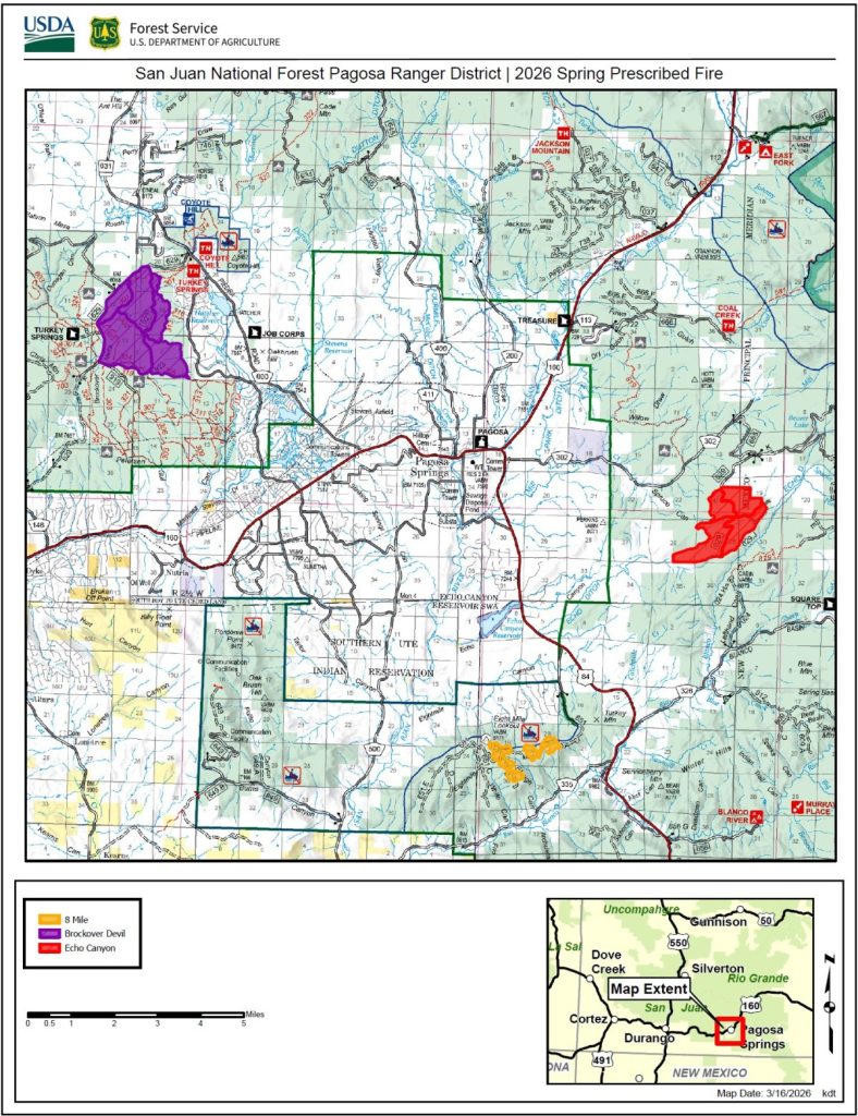
Beginning in late March, the Pagosa Ranger District plans to implement multiple prescribed fire projects in Archuleta County as weather and conditions allow. Follow link for more information.
Long Range
The next post will be on Saturday.
– Arleen


