

Thanks for coming out to “The world’s shortest St Patrick’s Day Parade”! – pic taken by Jenny Lyn Heckmann of North Creek Photography on 3/14/2026
Sunday – 15 Mar 2026 – 2:00pm
The past…
Stevens Field Observations
Friday: High: 63, Low: 23, Peak wind: 23mph
Saturday: High: 64*, Low: 24, Peak wind: 37mph
* Beat the previous record high of 62 set in 1995.
| Average High | Record High / Year | Average Low | Record Low / Year |
| 48 | 62 / 1995 | 14 | -10 / 1912 |
Precipitation summary… There has been no recent measurable precip.
Current satellite and radar…

I don’t usually pan this far out, but I wanted to show the warm, moist, subtropical air that is feeding the “hell high”. By the middle of next week, it will park over southern AZ and cause record high temps across the region.
There is nothing on radar in our area Sunday afternoon.
Forecast highlights…
*** Gusty winds until around sunset Sunday. ***
*** Break out the shorts and t-shirts – record high temps next week. ***
*** Dry through around 24 Mar and then a slightly more active weather pattern. ***
Forecast details…
Monday through next Sunday (22 Mar)… The “hell high” will build over the southwest US. It will park over southern AZ Tuesday through Saturday. The storm track will be well to our north.
We’ll have lots of sun and remain dry. Temps will be 25 degrees above average Wednesday through next Sunday. Record high temps are likely.
Next Monday and Tuesday (23 and 24 Mar)… The “hell high” will weaken and move slowly east. We’ll have a more typical dry, southwest flow for this time of year. High temps will be around 10 degrees cooler, but that’s still 10 degrees above average!
Temps…
Sunday night lows will be in the low teens to low 20s.
Monday highs will be in the mid 50s to low 60s and lows will be in the low 20s to the low 30s.
Tuesday highs will be in the mid 60s to low 70s and lows will be in the mid 20s to mid 30s.
Wednesday, through next Sunday (22 Mar) highs will be in the low 70s to the low 80s and lows will be in the high 20s to high 30s. Our friends in Arboles with have highs in the mid to high 80s.
Next Monday and Tuesday highs will be in the mid 60s to low 70s and lows will be in the mid 20s to mid 30s.
Winds…
Monday afternoon gusts will be around 20mph in the Pagosa Springs area and 30-35mph in the high country.
Tuesday through Saturday, each afternoon gusts will be 10-15mph in the Pagosa Springs area and around 25mph in the high country.
Next Sunday through next Tuesday, each afternoon gusts will be around 20mph in the Pagosa Springs area and 30-35mph in the high country.

*** Note: Our record high for the month of March is 73 set on 19 Mar 1907, 23 Mar 1940, and 25 Mar 1940. ***
22 Mar to 30 Mar… Starting around 25 Mar, the ridge will flatten and might allow some moisture to move into our area. I still don’t see any good soakings on the horizon, but any moisture is better than none!

There is a slight upward trend in precip amounts, but it still isn’t much.
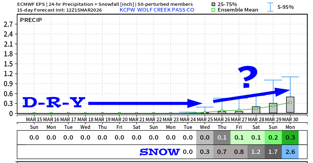
It’s dry until around the 25th, and then the weather pattern will try to get a little more active.
The next post will be on Tuesday.
– Shawn


