

“Old Fashion Christmas” in downtown Pagosa Springs – Pic taken 12/20/2025 by Arleen
Sunday – 21 Dec 2025 – 3:15pm
The past…
Stevens Field Observations
Friday: High: 53, Low: 20, Peak Wind: 9mph
Saturday: High: 53, Low: 21, Peak Wind: 13mph
| Average High | Record High / Year | Average Low | Record Low / Year |
| 38 | 55 / 1958 | 3 | -32 / 1951 |
Precipitation summary… There has been no recent measurable precip.
Current satellite and radar…

There is nothing on radar in our area Sunday afternoon.
Forecast highlights…
*** A few more clouds, dry, and warm temps through Tuesday. ***
*** Christmas rain for Pagosa and snow for Wolf Creek. ***
*** Wednesday afternoon through Friday evening expect periods of poor visibility, falling snow, and slick roads in the mountains. ***
Forecast details…
Rest of Sunday through Tuesday… The giant, blocking, evil ridge is slowly moving east but it continues to force the storm track to our north. We’ll see a few more clouds, but temps will remain 10-15 degrees above average.
Tuesday night through next Monday… With the ridge to our east, a long moist fetch out of the southwest will bring us more clouds and multiple chances for precip.
Specific timing, snow levels, and precip amounts…
Tuesday night through Wednesday morning the first surge of moisture will kick up a few scattered showers over the mountains above 10,000ft. Wolf Creek Pass could get an inch of snow resulting in slick roads.
Wednesday afternoon through Friday evening the ingredients come together for a good round of rain in the Pagosa area and snow in the mountains. Precip will start as scattered showers Wednesday afternoon, ramp up Wednesday night, fall steadily through Christmas evening, and then become hit and miss showers through Friday evening.
Expect winter driving conditions in the mountains with poor visibility, falling snow, and slick roads.
Precip amounts Wedenday afternoon through Friday evening…
Mountains above 9,500ft: 10-16” of snow
Pagosa area: 0.50” to 1” of rain
Most of the precip will fall midnight Wednesday to midnight Thursday.
* Friday night through next Monday * moisture will gradually decrease but scattered showers will persist. The snow level will bounce around between 7,500ft at night to 8,500ft during the day. The stronger showers each night could briefly drop the snow level to around 7,000ft.
Snow amounts Friday night through next Monday (26-29 Dec) …
Above 8,500ft: 4-8”
7,500ft to 8,500ft: 1-3” – most will fall at night and melt during the day
Less than 7,500ft: a dusting to 1” – will fall at night and melt during the day
* Forecast confidence is still low for this period. * I will continue to adjust the details as the storm gets closer and the data gets better.
Temps…
Sunday through Tuesday highs will be in the low to high 50s and lows will be near 20 to the mid-20s.
Wednesday highs will be in the high 40s to mid-50s and lows will be in the high 20s to high 30s.
Christmas and Friday highs will be in the mid to high 40s and lows will be in the low to high 30s.
Saturday through the following Monday highs will be in the low to mid 40s and lows will be in the high 20s to mid-30s.
Winds…
Sunday through Wednesday afternoon peak winds will be 10-15mph each day in the Pagosa area. In the high country, winds will gust 25-35mph.
Thursday and Friday afternoon gusts will be 15-20mph in the Pagosa area. The windy spots could gust to 25mph Friday afternoon. In the high country, winds will gust 35-45mph.
Next weekend afternoon peak winds will be 10-15mph in the Pagosa area. In the high country, afternoon gusts will be 20-25mph.

30 Dec through 5 Jan… The forecast models are all over the place for this period. The good news is that the pattern should remain active. Outcomes range from light amounts of precip to another pretty good storm.

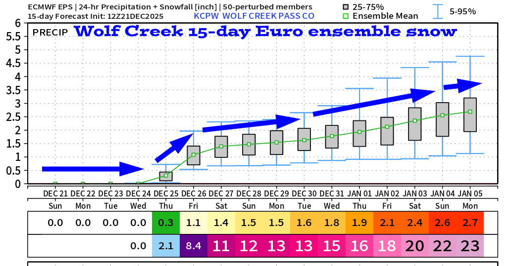
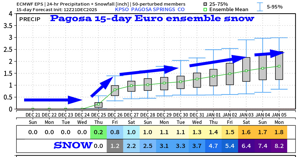
It’s great to see a steady upward trend!
The next post will be on Tuesday.
– Shawn


