

Incredible reflection at the lake. Where does the lake end and the shore begin? – Photo taken 11/27/2025
Friday – 28 Nov 2025 – 2:45pm
The past…
Stevens Field Observations
Wednesday: High: 47, Low: 26, Peak Wind: 9mph
Thursday: High: 56, Low: 21, Peak Wind: 6mph
| Average High | Record High / Year | Average Low | Record Low / Year |
| 43 | 61 / 1966 | 10 | -15 / 1952 |
Precipitation summary… There has been no recent measurable precip.
Current satellite and radar…

The little trough over northern ID and western MT will quickly move through northern CO tonight and tomorrow morning.
There is nothing on radar in our area Friday afternoon.
Forecast highlights…
*** Friday through Sunday morning will be dry. ***
*** A little snow late Sunday afternoon into Monday morning. ***
*** Expect winter travel conditions through the mountains Sunday evening through Monday morning. Roads could also be slick in the Pagosa area. ***
*** Monday afternoon through Wednesday morning will be dry. ***
*** Potential for a little more snow late Wednesday afternoon into Thursday morning. ***
*** Next weekend looks dry. ***
Forecast details…
Friday night and Saturday… A weak trough will move through northern Colorado Friday night and Saturday morning. We’ll see a few more clouds and there could be a dusting of snow along The Divide in our mountains.
Sunday through Monday morning… A trough will dip into UT from the northwest and then move quickly through CO from the west. It’s not a favorable snow maker for us.
The good news is that temps will be chilly, and the snow level will be less than 7,000ft. In the mountains temps will be in the teens leading to 20:1 ratio powder that accumulates quickly.
Timing… The first scattered snow showers will start over the mountains late Sunday morning and then over the valley Sunday afternoon. The best chance for snow is late Sunday afternoon into early Monday morning. Hit and miss snow showers will persist through Monday morning, mostly over the mountains.
Snow forecast…
Mountains: 4-8”
Pagosa area: 1-3”
Monday afternoon through Wednesday morning… A transient ridge and dry flow out of the northwest will give us dry weather and partly cloudy skies. Temps will be 5-10 degrees below average.
Wednesday afternoon through Thursday morning… Another fast-moving trough could move through the area from the northwest. I don’t have much confidence in this system.
Right now snow amounts range from nothing to a few inches in the mountains.
Thursday afternoon through next weekend… A Rex block will set up off the southern West Coast and keep the dreaded, dry flow out of the northwest over us. Temps will gradually warm towards average.
Temps…
Friday highs will be in the high 40s to mid-50s and lows will be in the mid-teens to mid-20s.
Saturday highs will be in the mid-40s to low 50s and lows will be in the mid-teens to mid-20s.
Sunday through Wednesday highs will be in the mid-30s to low 40s and lows will be in the low teens to low 20s.
Thursday and next Friday highs will be in the high 30s to mid-40s and lows will be in the low to high teens.
Winds…
Friday and Saturday afternoon gusts will be around 15mph.
Sunday afternoon winds will gust 15-20mph.
Monday through next Friday afternoon gusts will be 10-15mph.
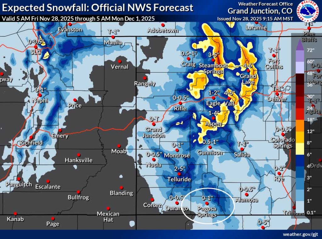
The northern CO mountains will be favored.
The 8-14 day period… Upper level flow will remain in a La Nina-like pattern. The storm track over our region will be out of the northwest which means northern CO is favored and we get a few scraps.


The next post will be on Sunday.
– Shawn


