

IZZABELLA has been at the Humane Society since Oct 2022 – nearly 2 and a half years! She’s obedient and smart. She knows sit, stay, high five, lay down, and is easy to walk. Give this girl a chance and you’ll have a fantastic friend!
Sunday – 2 Mar 2025 – 4:00pm
The past…
At Stevens Field the high temperature on Friday was 57 and on Saturday it was 63 – tied the record set in 1943. The low this morning was 30.
The peak wind at Stevens Field Friday afternoon was 17mph and on Saturday afternoon it was 18mph.
| Average High | Record High / Year | Average Low | Record Low / Year |
| 44 | 60 / 1986 | 12 | -15 / 1913 |
Precipitation summary… There has been no recent measurable precip. Last night’s low-pressure slid 100 miles too far to our south.
Forecast discussion…
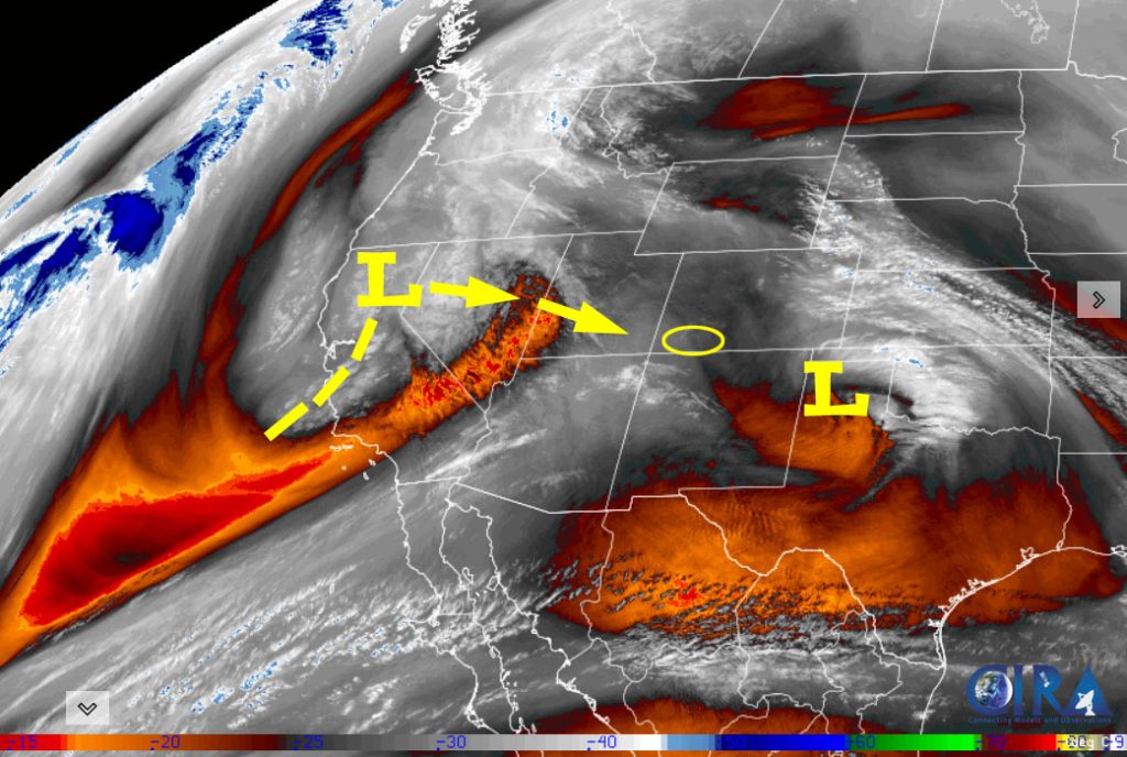
There is nothing on radar in our area Sunday afternoon.
Forecast highlights…
*** The Pueblo NWS has issued a WINTER WEATHER ADVISORY for the eastern San Juan Mountains – this includes Wolf Creek and Cumbres Passes. 4-8″ of snow and winds gusting to 45mph are possible from 5am Monday to 5am Tuesday. *** This does not include Pagosa Springs.
*** Scattered snowflakes early Monday morning to early Tuesday afternoon, and then our best chance for snow is early Thursday morning into Friday afternoon. ***
*** Stormy again 11-13 March. ***
Sunday afternoon into early Monday morning… A transient ridge will keep us dry. Clouds will increase and winds will be a little gusty Sunday afternoon.
Temps… Sunday highs will be in the mid to high 50s and lows will be in the low 20s to low 30s.
Winds… Sunday afternoon gusts will be around 20mph.
Early Monday morning into early Tuesday afternoon… A trough with a little more moisture and storm energy will move through. Snow levels will be around 7,000 each afternoon and temps will be above freezing so snow will struggle to accumulate.
Snow amounts…
Mountains: 3-5”
Pagosa area: up to 1”
Temps… Monday highs will be in the mid-30s to low 40s and lows will be in the mid-teens to the mid-20s. Tuesday highs will be in the low to high 40s and lows will be in the low teens to low 20s.
Winds… Monday afternoon gusts near Pagosa will be 25-35mph and in the mountains gusts will be 40-50mph. Tuesday afternoon gusts near Pagosa will be 20-30mph and in the mountains gusts will be 30-40mph.

Late Tuesday afternoon to late Wednesday evening… A transient ridge will give us a brief break. Clouds will clear Tuesday night and temps will cool.
Temps… Tuesday night lows will be in the high single digits to high teens. Wednesday highs will be in the mid-40s to low 50s.
Winds… Wednesday afternoon gusts will be 15-20mph.
Wednesday night through Friday afternoon… Another low-pressure system will move through. It will have a little more moisture and storm energy, so I expect a little more snow.
The best chance for snow is after sunrise on Thursday to around sunrise on Friday. Hit and miss showers are likely before and after that time period.
Snow amounts…
Wolf Creek area: 6-10”
Pagosa area: 2-4”
I’ll adjust the timing and snow amounts as the data gets better.
Temps… Wednesday night low will be in the low 20s to low 30s. Thursday highs will be in the high 30s to mid-40s and lows will be in the high teens to mid-20s. Highs Friday will be in the mid-30s to low 40s.
Winds… Thursday afternoon gusts near Pagosa will be around 25-35mph and in the mountains gusts will be 40-50mph. Friday afternoon gusts will be around 20mph.

Friday night through next Monday… A ridge will give us lots of sun and a warming trend.
The 8-14 day period… It will be dry 8-10 Mar and then more active 11-15 Mar.

It’s great to see this much moisture across the western US!

Unless there is a big change to my forecast, the next post will be on Tuesday.
– Shawn


