

Wolf Creek Pass could be slick Sunday morning into Monday afternoon – Pic taken 10/31/2024
Saturday – 2 Nov 2024 – 1:15pm
The past…
At Stevens Field the high temperature on Friday was 53. The low Saturday morning was 24.
The peak wind at Stevens Field on Friday was 6mph.
| Average High | Record High / Year | Average Low | Record Low / Year |
| 54 | 75 / 1945 | 20 | 4 / 1929 |
Precipitation summary… There has been no recent measurable precip.
Forecast discussion…


Forecast highlights…
*** Sunday morning into Monday afternoon roads could be slick, especially in the mountains. ***
*** Wednesday into Friday the first good snow of the season is possible in the valley. ***
Saturday evening through Monday evening… A low will move west to east across central NM. Upper-level flow and storm energy won’t line up well for us, so I don’t expect much precip.
Timing…
Scattered snowshowers will start over the mountains early Sunday morning and then over the valley after sunrise Sunday. Hit and miss showers will persist until the system moves through Monday evening. Precip will be mostly light but could cause poor driving conditions, especially in the mountains.
Snow levels will be 7,500-8,000ft during the day and 6,500-7,000ft at night.
Snow amounts for this period:
Mountains above 9,000ft: 3-6”
Valley: up to 1”
Winds… Afternoon gusts will be 15-20mph
Temps… Highs will be in the low to high 40s. Saturday and Sunday lows will be in the low 20s to low 30s. Monday lows will be in the mid-teens to mid-20s.

Tuesday… Transient ridging will give us a brief break. Patches of clouds will continue to move through. The mountains could get a few spotty snowshowers Tuesday night.
Winds… Afternoon gusts will be around 15mph.
Temps… Highs will be in the low 40s to low 50s and lows will be in the high teens to mid-20s.
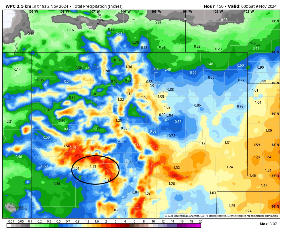
Early Wednesday into Friday afternoon… The next low-pressure system will move through. Some forecast models expect the storm to end late Thursday, while some have it lingering into Saturday morning. At this point, I think it will linger into Friday afternoon.
Timing… The first scattered snowshowers will start over the mountains after midnight Tuesday and then over the valley around sunrise on Wednesday. The heaviest precip is possible Wednesday morning into Thursday afternoon and then will become hit and miss into Friday afternoon.
Snow levels…
Wednesday: 6,500-7,000ft
Thursday: 7,000-7,500ft
Friday: around 7,000ft
Snow amounts for this period…
Mountains above 9,000ft: 12-20”
Valley above 7,600ft: 6-10”
Valley below 7,600ft: 3-6”
Note: Temps in the valley will be above freezing during the day so snow will struggle to accumulate.
Winds… Gusts will be 15-20mph.
Temps… Highs will be in the mid-30s to low 40s and lows will be in the low to high 20s.
My next post will be on Sunday.
– Shawn


