Ingredients are in place for good a soaking…

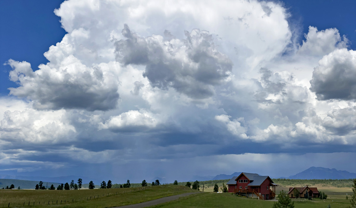
Impressive cumulonimbus cloud Tuesday afternoon – pic taken 8/6/2024

Impressive cumulonimbus cloud Tuesday afternoon – pic taken 8/6/2024

If images fail to load in the email, please click the title of the post. Thanks!

Thursday – 8 Aug 2024 – 10:20am

The past…

At Stevens Field the high temperature Tuesday afternoon was 89 and the high on Wednesday was 83. The low this morning was 55.

The minimum relative humidity Tuesday was 22% with a dew point of 42. Wednesday it was 24% with a dew point of 43. At 9am Thursday morning it’s 47% and 47.

The peak wind at Stevens Field Tuesday afternoon was 32mph and on Wednesday it was 32mph.

Average HighRecord High / YearAverage LowRecord Low / Year
8290 / 19694529 / 1956

Precipitation summary… The trend continues – Some folks barely get anything while some get a good soaking. 
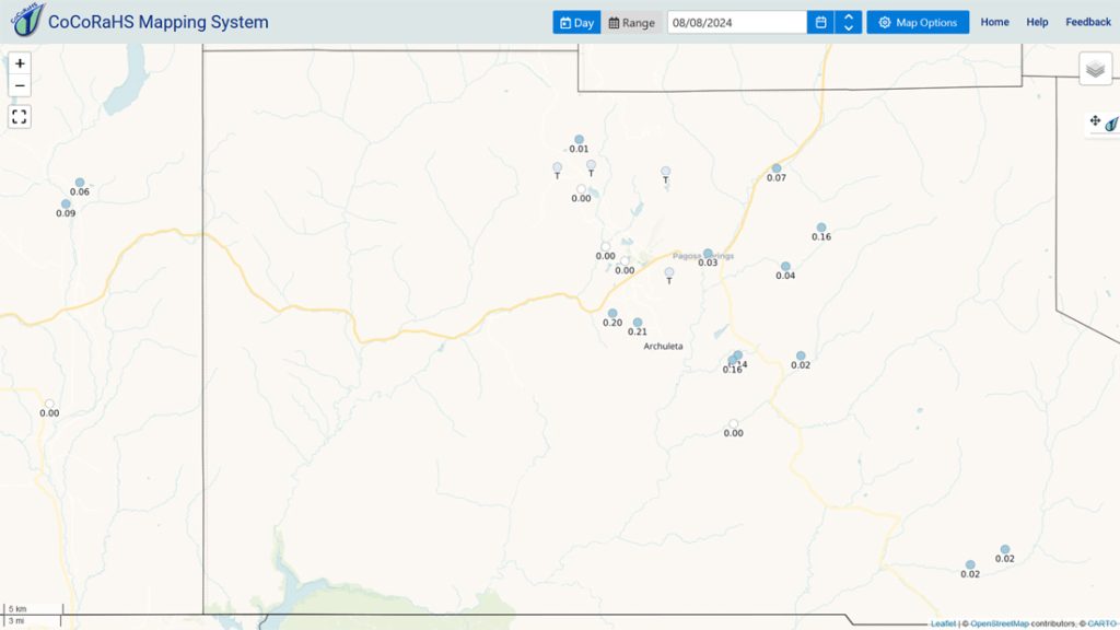
CoCoRaHS 24-hour precip reported Thursday morning ranged from zero to 0.21”. The rain lottery winner was Jeb and Leah in Meadows.
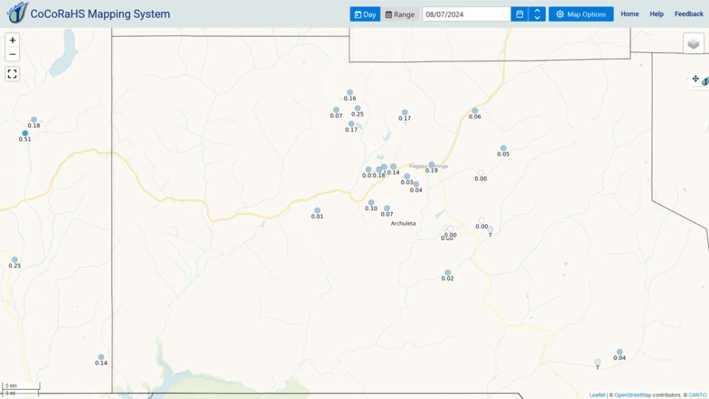
CoCoRaHS 24-hour precip reported Wednesday morning ranged from zero to 0.25”. The rain lottery winner was Mark just north of Hatcher Lake.

River levels… San Juan River flow nearly tripled last night around midnight from 58cfs to 165cfs. We’re going to see more of this over the next few days.
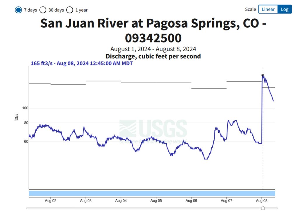
San Juan River flow has been low during the last week but there was a rain-induced spike last night.  We’ll see more of that over the next few days.

Forecast discussion…
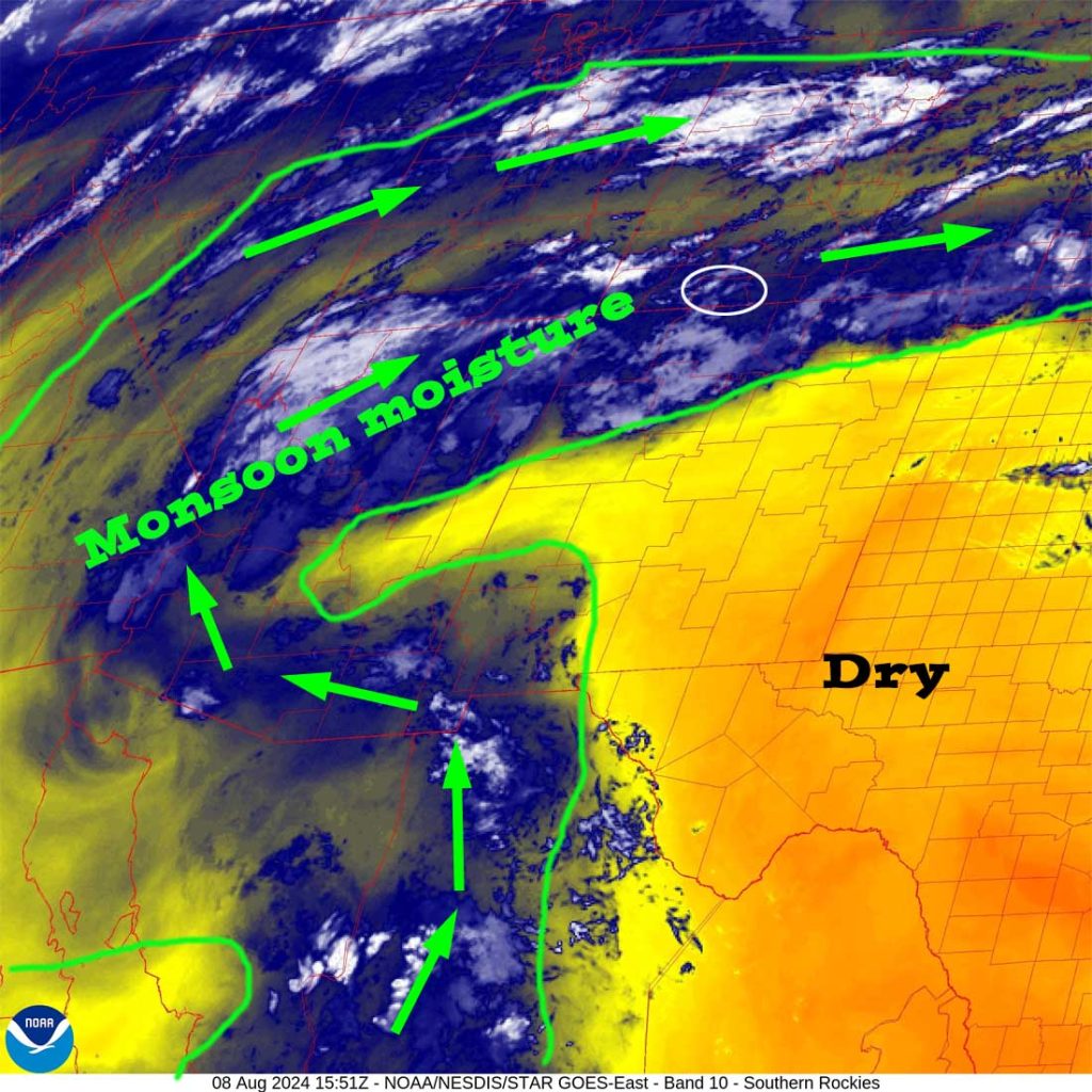
Water vapor satellite Thursday morning – The heart of the monsoon moisture plume is over our heads and will stick with us into Sunday evening.

There is nothing on radar in our area this morning.  That will change this afternoon.

Forecast highlights…

*** Thursday afternoon through Sunday evening storms possible any time of day, but the best chance for storms is late each afternoon into each evening. ***

*** All storms are capable of short periods of heavy rain, small hail, gusty winds, and lightning. ***

*** Streams will rise, and minor flooding is possible in low-lying areas. ***

Rest of Thursday through Wednesday… The heart of the monsoon moisture plume will be over our heads late Thursday afternoon into Sunday evening.  Precipitable water, the amount of water available for precip, will be 150% to 175% of average.  That means we should get a good soaking.

Precipitable water will gradually decrease Monday through Wednesday so there will be fewer storms, but lucky folks will get a good soaking each day.

Thursday afternoon into Sunday evening storms are possible any time of day, but the best chance for storms is each afternoon into each evening.  Monday through Wednesday, scattered storms will occur each afternoon into each evening.

Winds… Afternoon peaks will be around 15mph, but isolated higher gusts are likely near showers and thunderstorms.

Temps… Thursday highs will be in the low to high 80s and lows will be near 50 to mid-50s. Friday through Sunday highs will be in the low 70s to low 80s and lows will be near 50 to the mid-50s. Monday through Wednesday highs will be in the mid-70s to low 80s and lows will be in the high 40s to mid-50s.
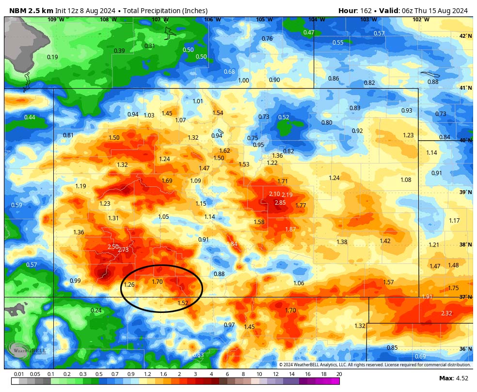
NBM precip to late Wednesday evening expects 1.70” in the Pagosa area. Precip will vary considerably. I won’t be surprised to see a single storm drop nearly an inch over a small area in just a short period.

8-14 day precip… Monsoon moisture will decrease a bit as a low pressure trough moves through the Pacific NW and temporarily knocks down our subtropical ridge. We’ll continue to see afternoon storms, but they will be more hit and miss.
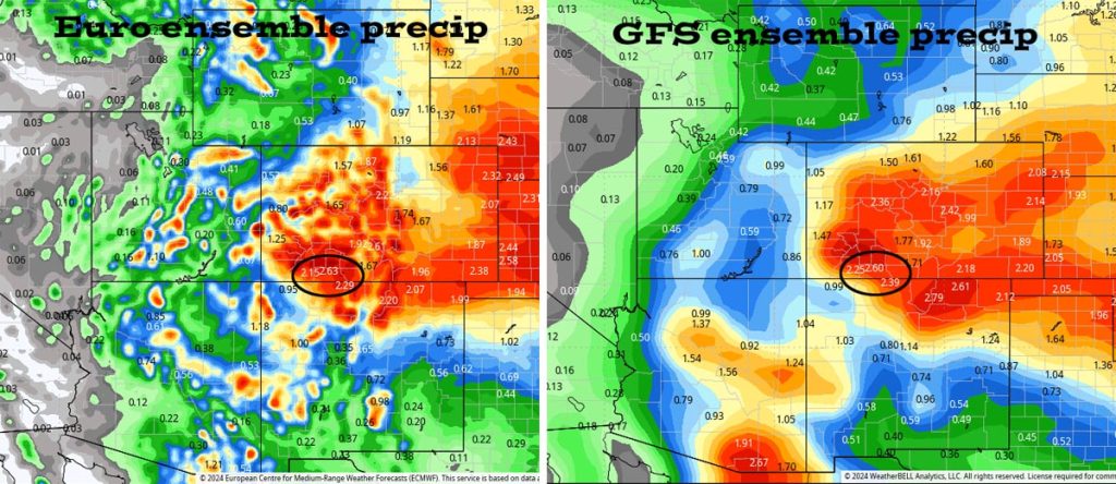
Euro ensemble precip on the left to 6pm 22 Aug expects 2.63” while GFS ensemble precip on the right expects 2.60”.  It’s all convective showery precip, so amounts will vary considerably.

The next forecast post will be Saturday afternoon.

– Shawn

Pagosa Weather Blizzard Level Sponsor

Pagosa Weather Storm Sponsor

Picture of Shawn Pro

Shawn Pro

I’ve been a “weather geek” since I was young child. I joined the military out of high school and was lucky to get my dream job in weather. I have 20 years of military weather experience which includes forecasting the weather all over the world. Highlights were six years in Alaska and making life and death weather decisions during deployments. I love mountains, I love snow, and I love summertime thunderstorms. I spend a bunch of time playing outdoors and found my paradise in Pagosa Springs. I do Pagosa Weather as a community service. Hopefully you find us helpful!

Leave a Reply

Your email address will not be published. Required fields are marked *

Pagosa Weather Disclaimer and Release of Liability

This website makes no guarantees about nor bears any responsibility or liability concerning the accuracy or timeliness of the weather information published on this website. All weather information published on this website is for educational and weather enthusiast purposes only. We do not issue Storm Watches, Warnings or Advisories as that ability falls with the National Weather Service, who is the only institution allowed to issue such warnings by law. We are not in any way linked nor affiliated with the National Weather Service, although we do share information and relay weather watches/ warnings, etc. Use of the information on page is at your own risk/discretion, and we are not responsible for any personal/property damages, injury or death associated with weather forecasts, reports or other information as well as communication exchanged in private messages and/or person.

Terms of Use                  Privacy Policy

© 2026 Pagosa Weather 

Website Design by : Brandon