

Wild Flowers are poppin’ in the San Juan Mountains! Purple Fringe leading the dance! Picture credit: Shawn Prochazka (Click on title of post to see image)
Friday – 19 July 2024 – 5:00pm
“Thunder blossoms gorgeously above our heads, Great, hollow, bell-like flowers, Rumbling in the wind… Dripping rain like golden honey…” Jean Toomer
The past…
At Stevens Field the high temperature Thursday afternoon was 80 and the high so far on today (Friday) is 79. Yesterday morning it was 52. The low this morning was 54.
The minimum relative humidity yesterday was 29% with a dew point of 43. Today it was 27% with a dew point of 43. This is still marginal moisture though it has increased slightly this week. For good monsoon action, we like to see the dew points around 50.
The peak wind at Stevens Field yesterday afternoon was 18mph. Today’s peak wind so far today was 28mph at 13:35mph associated with a thunderstorm at the airfield.
| Average High | Record High / Year | Average Low | Record Low / Year |
| 82 | 96 / 1989 | 47 | 35 / 1956 |
Precipitation summary… Well, the monsoon has dipped on us when we were expecting a twirl. Showers and thunderstorms were “spotty” over the last few days. Most locations got less than a tenth of an inch of precip each day while a few lucky folks get a good soaking.
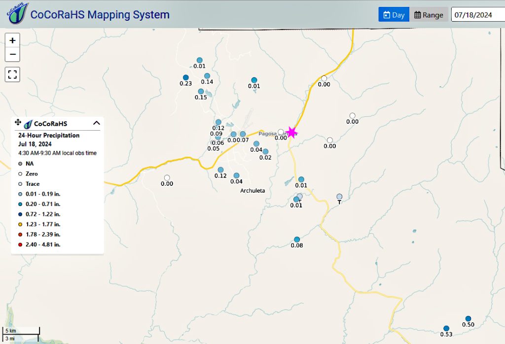
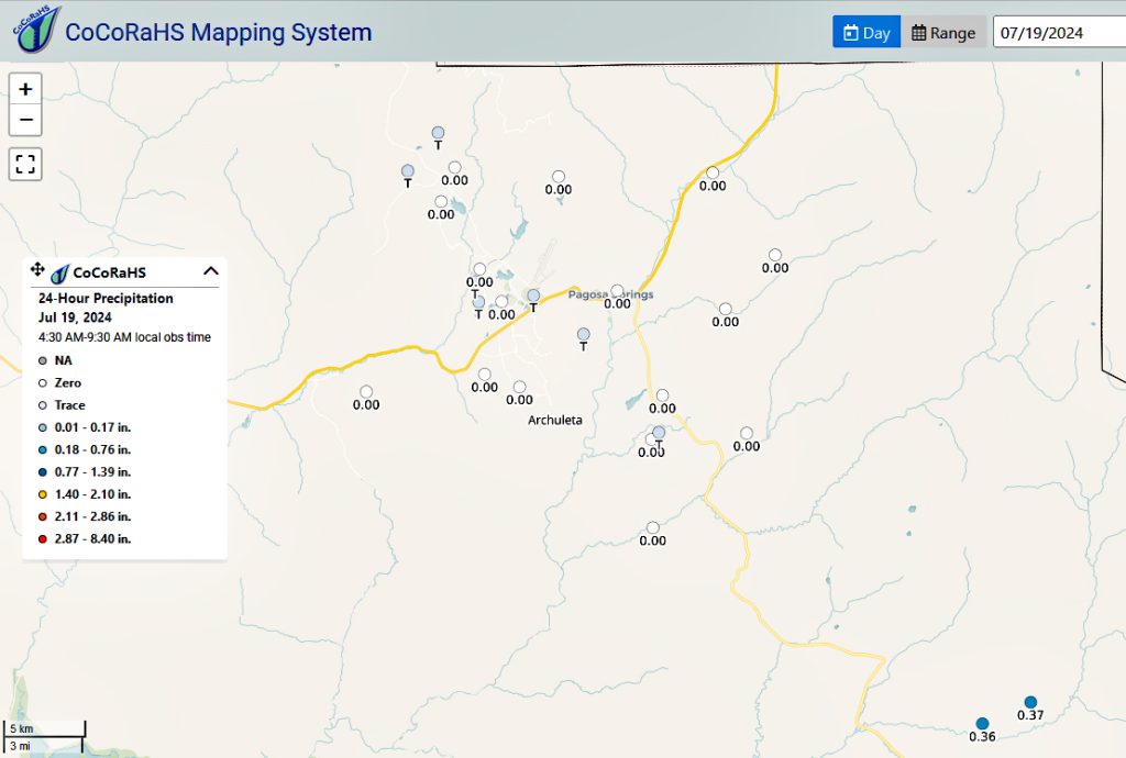
CoCoRaHS 24-hour precip reports from this morning for THURSDAY afternoon showers range was worse and ranged from a lot of zeros to 0.37”. The rain lottery winner was Robyn in Chromo! The Chromo ladies have done great in the last two day!
Forecast discussion…
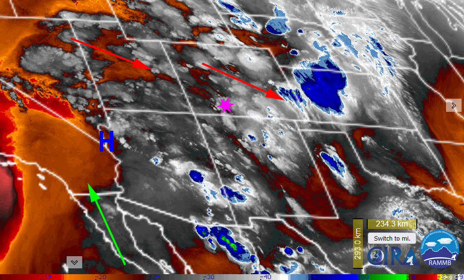
Satellite Imagery Valid: Friday, 19 Jul 24 5:00pm shows moisture moving from the northwest around the ridge which is to our west. Storm movement is to the southeast across Archuleta County. It also shows deep tropical moisture advecting up from the south into Arizona. This moisture will get wrapped up in the ridge along with moisture that is already there and will increase our chance for thunderstorms/showers through the weekend.
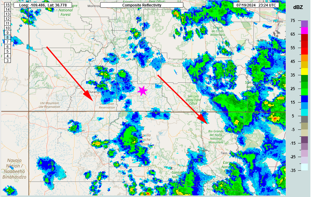
Radar at 5:24pm Friday evening – A weak line of showers is to our northwest and will move over our area right in time for some sunset showers!
Forecast highlights…
*** A 60-80% chance that you will get hit by a shower or thunderstorm each afternoon through and including Monday. ***
*** All storms are capable of short periods of heavy rain, small hail, gusty winds, and lightning. ***
Today through Monday: The dance with the monsoon. We analyze and forecast what is going to happen and the monsoon takes a different direction. Yesterday and today so far have been disappointing other than for the folks east of Hwy 84 in the Chromo area.
The high has shifted west and is currently over southern Nevada. A ridge extends north of that into northern Utah. This is not ideal for us but (for now) there is some moisture that is advecting north into the intermountain rocky region from the Gulf of Mexico and the Baja areas. Plus, we continue to recycle the moisture that is here.
A deep unseasonably cool trough sunk into the mid-west so the upper-level high retrograded to the west. For now, the precipitable water numbers remain favorable despite the northwest flow over us.
The trough to our northeast is causing a bit of squeeze play with the ridge. This will help destabilize our atmosphere and enhance thunderstorm activity.
Each morning we’ll wake up to bright blue skies. Then scattered cumulus clouds will build over the mountains by mid-morning. By mid day, those cumulus clouds will grow into round one of showers and thunderstorms. Then it will be calm for a bit before round two kicks off. Saturday, there is the potential for a round three and nocturnal thunderstorms.
The storms will move at us from the north-northwest through Monday.
Clouds will decrease late each evening. We still have smoke advecting into the area from wild fires throughout the western states. So the combination of lingering multi level clouds and smoke will treat us to pretty sunsets and maybe even a rainbow!
Winds… Afternoon peaks will be around 15mph, but isolated higher gusts are likely near a shower or thunderstorm. Given the squeeze play of the unseasonable trough in the mid-west, we could higher winds on Sunday and Monday.
Temps… Highs today through Monday will be in the mid 70s to low 80s and lows will be in the mid 40s to low 50s.

Other forecast models precip total for the same period: Euro: 0.31”, GFS: .48”, WPC: 0.37”, Canadian: .68”.
The lower Euro amounts are more reasonable. Under this pattern, expect to see the Chromo ladies continue to do better.
Tuesday through Thursday: The ridge will remain to our west. The monsoon will start to dry out for our area. Though we’ll still see thunderstorms in the area each day, they will be higher based with little rain and more wind.
Each morning we’ll wake up to bright blue skies. Then scattered cumulus clouds will build over the mountains by early afternoon. By late afternoon, those cumulus clouds will grow into showers and thunderstorms.
The storms will move at us from the north-northwest.
Clouds will decrease late each evening. We will still have smoke advecting into the area from wild fires throughout the western states. So the combination of lingering multi level clouds and smoke will treat us to pretty sunsets!
Winds… Afternoon peaks will be around 15mph, but isolated higher gusts are likely near a shower or thunderstorm.
Temps… We’ll be warmer. Highs will be in upper 70s to high 80s and lows will be in the mid 40s to upper 40s.
8-14 day precip… Another unseasonable deep cold trough starts to pushes into the northwest from the Gulf of Alaska. Our ridge will weaken and sink into the Baja area. That will cut off our monsoon moisture and we’ll see a few dry days.
Fortunately, the ridge will build back and all models are bringing it back just to our east. However, it will take a few days for the monsoon moisture to wrap into our area, again.

Euro ensemble precip above to 6pm 2 Aug expects 1.01” while GFS ensemble precip below expects 1.97”. Still a significant difference over the next two weeks. It’s all convective, showery precip so amounts can vary greatly.

We look forward to your reports! Shawn will have the next forecast post on Sunday.
– Arleen


