

This storm hammered us at Mesa Verde National Park – pic taken 6/27/2024
If images fail to load in the email, please click the title of the post. Thanks!
Sunday – 30 June 2024 – 4:20pm
The past…
At Stevens Field the high temperature Saturday afternoon was 83 and so far on Sunday it was 79. The low this morning was 58.
The minimum relative humidity today was 36% with a dew point of 49. Yesterday it was 22% with a dew point of 40.
The peak wind at Stevens Field yesterday afternoon was 22mph, Today’s highest wind so far is 7mph.
| Average High | Record High / Year | Average Low | Record Low / Year |
| 82 | 101 / 1934 | 41 | 28 / 1942 |
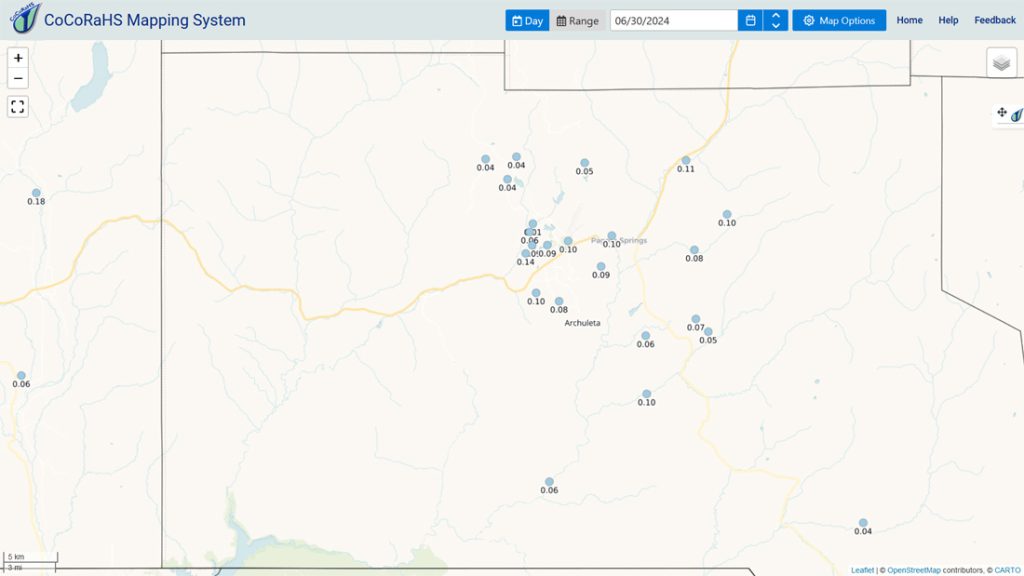
Precipitation summary… Most of the county got some precip Saturday evening and then again later Saturday night.
Forecast discussion…

A thunderstorm moved through the Chromo area during the last hour.

Forecast highlights…
*** The Grand Junction NWS has issued a FLOOD WATCH for all of southwestern Colorado valid through Monday afternoon. ***
*** A drier weather pattern will start to set up Tuesday and could last a week or longer. ***
Rest of Sunday and Monday… Another surge of tropical moisture is over our heads and will stay with us into Monday evening. The best chance for precip is late Sunday evening into early Monday evening. Precip will come in waves, occasionally heavy for brief periods. Lightning, small hail, and gusty winds are also possible.
Winds… Afternoon gusts will be 15-20mph, but isolated stronger gusts are possible near showers and thunderstorms.
Temps… Highs will be in the mid-70s to mid-80s and lows will be in the high 40s to mid-50s.

Amounts from other forecast models for after-the-fact verification: NBM: 0.95”, Euro: 1.97”, Euro ensemble: 1.98”, GFS: 0.54”, GFS ensemble: 0.77”, Canadian ensemble: 0.53”.
Tuesday and Wednesday… Moisture and instability will decrease giving us just a slight chance for a spotty shower or a thunderstorm each afternoon into each evening.
Winds… Afternoon gusts will be 15-20mph, but isolated stronger gusts are possible near showers and thunderstorms.
Temps… Highs will be in the high 70s to mid-80s and lows will be in the mid-40s to low 50s.
Thursday through Sunday… Unfortunately the upper-level high will set up to our west. Flow over us will be mostly out of the northwest and dry. Temps will be near seasonal averages, and I don’t expect any precip.
Winds… Gusts each afternoon will be 15-20mph.
Temps… Highs will be in the high 70s to high 80s and lows will be in the low to high 40s.
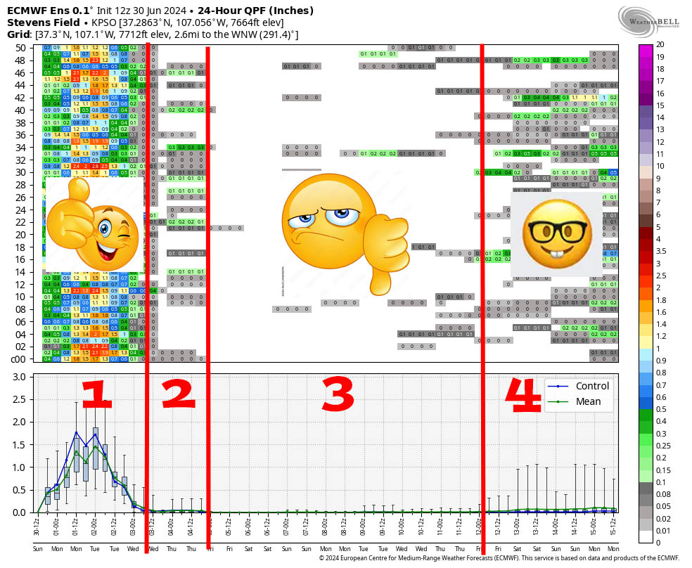
Explanation: 1. This model and most other forecast models expect significant precip over the next 24 to 30 hours.
2. There is a slight chance for low precip amounts Tuesday and Wednesday.
3. We could be dry for a week as the upper-level high sets up to our west and the monsoon moisture feed is cut-off.
4. A more active pattern will start set up 11/12 Jun as the high slowly moves east and allows moisture to slowly move back into the Four Corners region.
I will do another forecast post tomorrow afternoon. I will also work on the June summary/July outlook and hope to have that out by mid-week.
– Shawn


2 Responses
Thank you up to date and accurate information and sharing weather
You’re most welcome!