

Scud or low cumulus fractus floating through the area. Picture taken 21 June 24, 7:00am (Click on title of post to see image)
Friday – 21 June 2024 – 11:50am
Expect another round of heavy showers with hail and gusty winds this afternoon and this evening!
Alberto’s two day rain event on Thursday and Friday is sponsored by The Springs Resort!

The past…
At Stevens Field the high temperature yesterday afternoon was 76. The low this morning was 54. Some cool spots dipped to 50.
The peak wind at Stevens Field was at 6:35pm associated with thunderstorms was 33mph. Martha reported 43mph winds in Arboles associated with thunderstorms.
| Average High | Record High / Year | Average Low | Record Low / Year |
| 81 | 93/1954 | 37 | 26 / 1908 |
Precipitation summary… A number of bands of rain showers with hail and high winds moved through the area yesterday. Last night a wide band of rain moved through and most locations rained from around 10pm to about 3am. Both Joni and Lily reported marble size hail on the lower Blanco. Thankfully, there was minimal damage to Joni’s garden.
There was a definitive band that dropped over an inch total across the eastern side of the county. Sarah on Hwy 84 was the rain lottery winner with 1.39″!

Forecast discussion…
Satellite
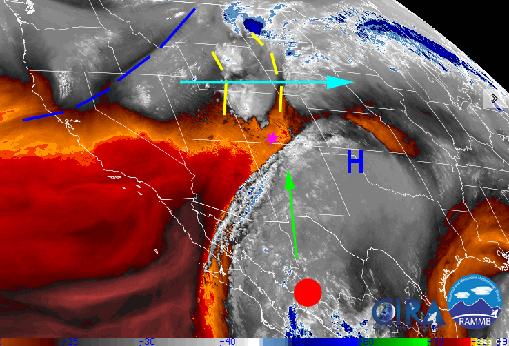
An area of high pressure is in place across the southern plains. The polar front jet is to our north with associated troughs moving from the west to the east enhancing shower activity. That is making a squeeze play with the remnants of Alberto and we’re in the middle.
Tropical Storm Alberto is now in northern Mexico moving towards the Baja area. His moisture is moving clockwise around the area of high pressure and moving to the northwest and towards southwest Colorado. It moved through most of New Mexico overnight.
Radar:

Forecast highlights…
*** Another round of heavy showers this afternoon and overnight! ***
*** Potential for severe thunderstorms with with hail and gusty winds this afternoon ***
*** Areas localized flooding in low lying areas or areas prone to flooding today ***
*** San Juan River has increased from 280 to 1,000CFS***
*** Drier Saturday through Tuesday with Afternoon Thunderstorms.
Today through Saturday morning…
All the players are in place for another decent soaking! This is a lot of moisture for this time of year and is a system more like what we could expect at the end of July!
The remnants of Tropical Storm Alberto is moving west across northern Mexico. His moisture is moving clockwise around the area of high pressure and moving to the northwest and towards southwest Colorado.
Today will be Mostly Cloudy to Cloudy. Moisture will continue to move into the area. Expect thunderstorm activity to resume in the early afternoon hours and increase in coverage throughout the evening hours. We’ll see more of a steady rain overnight ending in the early hours tomorrow morning. With the afternoon/evening thunderstorms expect heavy rain at times and the potential for 1/2″ size hail and very gusty winds associated with outflow from the storms.
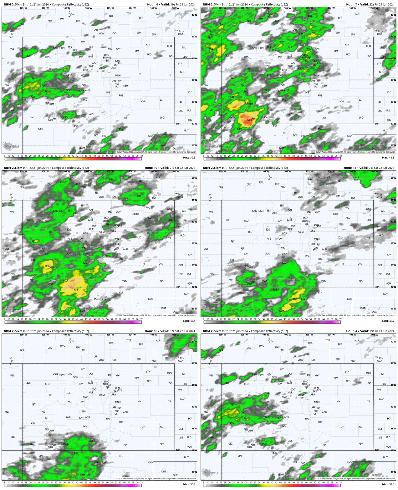

The models numbers for total precipitation till tomorrow morning at 3am. Though most of the county will not see the original forecasted numbers, some areas will! The WPC is a “forecaster in the loop” product and it is showing an additional 1.13″ by 6am on Saturday as compared to NBM: 1.16 Euro: 1.40” GFS: 2.18” Canadian: .68” HRRR: .69
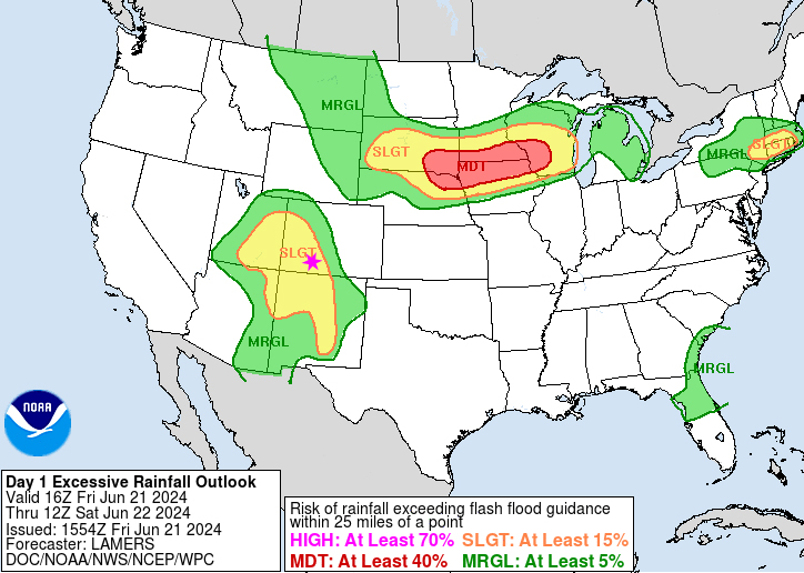
With this much additional rain, chance of localized flooding in low lying areas or areas prone to flooding is a real concern. WPC has highlighted areas of possible flooding in our area for today.
Cooler air associated with an upper level trough is moving in from the northwest. This is helping to destabilize the atmosphere. Cape, a measure of instability, will be what we need for showers and thunderstorms. The Cape values for thunderstorms are the highest around 6pm today.

Winds… Afternoon gusts will mostly be 10-15mph. Isolated stronger gusts are possible near showers and thunderstorms.
Temps… Highs will be only upper 60s to low-70s today and lows will be in the mid-40s to low 50s.
Saturday through Tuesday…
The upper level trough will move through our area late Friday night and very early Saturday morning. High pressure with more stable and drier air will move in. The long wave ridge that has been over the southern plains will retrograde and into the Southern Rockies area.
Skies will be Partly Cloudy. However, there will still be enough residual moisture left over to kick off isolated thunderstorms each afternoon. Expect Mostly Cloudy skies in the afternoon with those thunderstorms.
Winds… Afternoon gusts will mostly be 15-20mph. Isolated stronger gusts are possible near showers and thunderstorms.
Temps… Will increase each day. Saturday will in the upper 70s to lo 80s. By Tuesday it will be in the mid 80s to near 90. Lows will be in the upper 40s to lo 50s.
Huge thanks, again, to The Springs Resort for sponsoring our two day storm!
If we see something significant, we’ll make a quick post. Otherwise, Shawn will a wrap-up post out tomorrow afternoon.
– Arleen


