
It’s been perfect weather for walking pups at our Humane Society! I love walking sweet Bonnie, a 5-year old, Australian Shepherd – she just loves people. Her loving owner died recently so she is looking for a new fur-ever home.
If images fail to load in the email, please click the title of the post. Thanks!
Monday – 17 June 2024 – 5:00pm
The past…
At Stevens Field the high temperature Sunday afternoon was 84. The low this morning was 47. The cold spots were in the lo-30s. It was 31 by the Piedra Bridge! We’re getting chilly due to very dry air in place.
The peak wind at Stevens Field yesterday afternoon was 35mph and so far today the wind has also peaked at 35mph.
| Average High | Record High / Year | Average Low | Record Low / Year |
| 79 | 87/1986 | 36 | 24 / 1957 |
Precipitation summary… We have not had rain across the area for the last two days.
Forecast discussion…
Satellite

High Pressure is the dominant feature throughout the western United States. The polar front jet and areas of low pressure and upper level disturbances are staying north of us. There is a disturbance forming in the Gulf of Mexico. That is going to impact our weather later this week.
Radar: There is not any precipitation throughout the entire area at this time. That will change by late Wednesday evening.
Forecast highlights…
*** Monday through Wednesday: Sunny & dry, average temps, breezy afternoons. ***
*** Chance for a decent soaking: Late Wednesday till early Saturday. ***
*** Chance of localized flooding in low lying areas or areas prone to flooding Thursday & Friday***
Rest of Monday through Wednesday… A trough is moving through the Pacific Northwest but is staying well to our north. So the Continental Tropical warm, dry airmass will remain in control! With our temps increasing each day, so will our winds.
Winds… Tuesday, and Wednesday afternoons gusts will be around 25mph. Monday will have the strongest winds of the week with gusts around 35mph.
Temps… Highs will be in the high 70s to mid 80s and lows will be in the low to mid 40s.
Thursday through Saturday… Things are trying to line up for some decent rain. A tropical “disturbance” is forming in the warm Gulf of Mexico. It is forecast to get caught up in the low level flow and deep tropical moisture will be advected all the way from the southeast to southwest Colorado. These sorts of systems can vary drastically from one day to the next and it can be difficult to forecast their track.
At the same time an upper level disturbance is moving in from the northwest with cooler air in the upper levels. This will rapidly destabilize the atmosphere resulting in cloudy skies with thunderstorms and the potential for heavy rainshowers.
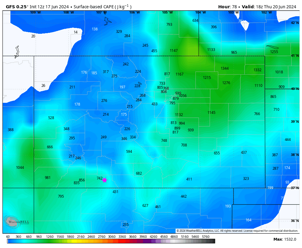
Precipitable water, the amount moisture available for precip, will be around 200% of normal early Thursday morning to Friday evening. Cape, a measure of instability, will be well above what we need for showers and thunderstorms. The Cape values for thunderstorms are the highest starting in the early morning hours of Thursday through the afternoon hours.
Winds… Afternoon gusts will mostly be 15-20mph. Isolated stronger gusts are possible near showers and thunderstorms.
Temps… Highs will be in the mid-70s and lows will be in the mid-40s to low 50s.

NBM: 1.74 Euro: 2.88” (ooo!) GFS: 1.19” Canadian: .79”
Euro ensemble: 2.23” GFS ensemble: 1.00” Canadian ensemble: 1.06”
If this system holds together and we see some of these heavier forecasted amounts of precipitation, we could see areas of localized flooding in low lying areas or areas prone to flooding.
I’ll keep an eye on this system. If I see any drastic changes, I’ll do an updated weather post. Otherwise, my next post will be Wednesday.
– Arleen


2 Responses
We are having an outdoor wedding Saturday at 4 pm, the 22nd. We live off Jack’s pasture road off piedra rd. Should we try to get a tent or will we be pretty safe from rain then?
Evelyn, The heaviest rains will be Thursday and Friday. However, there is still a chance for an isolated thunderstorm and rain shower from 1pm to 5pm. I’d have a backup plan. I hope it is a beautiful ceremony and I wish the couple all the best!