

The sunset was spectacular last night over Pagosa Peak! Pic taken 4/1/2024
Winter returns on Friday with winds and snow!
If images fail to load in the email, please click the title of the post. Thanks!
Tuesday – 2 Apr 2024 – 6:56pm
The past…
At Stevens Field the high temperature this afternoon was 55 and the low this morning was 23.
The peak wind at the airfield this afternoon was 21mph.
| Average High | Record High / Year | Average Low | Record Low / Year |
| 54 | 71/ 1971 | 21 | 1 / 1975 |
Precipitation summary… Wolf Creek reported zero new snow this morning and is holding at 312″ for the year. We had reports of light snow across the eastern part of the county yesterday.
THANKS to everyone for your reports and pictures on Facebook!

Forecast discussion…

High Pressure is the dominant feature across Colorado with only a few mid level and hi level clouds that can be found. The ridge running from upper Idaho to southeast Arizona will move slowly to the east. The frontal system and upper level jet will move in quicker from the northwest. The will result in a squeeze play! We’ll end up with winds starting on Thursday and really get cranking on Friday!
Radar: There is nothing on radar that is in our area or anywhere throughout the southwest.
Forecast highlights…
*** Lots of sun through Thursday***
*** More snow possible Friday evening to Saturday evening. ***
Tuesday, Wednesday, and Thursday… Ridging will push in from the northwest and give us lots of sun and pleasant spring temps. In fact Thursday will be well above average temperatures as warm air moves in from the southwest.
Winds… Tuesday and Wednesday afternoon peaks will be 10-15mph. Thursday afternoon peaks will be 15-20mph.
Temps… Lows on Wednesday morning will be in the low 20s to mid-20s. Highs Wednesday will be in the mid 50s to mid 60s. Lows Thursday will be mid-20s to low 30s, and the high temperatures will be in the hi-50s to hi-60s.
Friday and Saturday… The first of a double barrel low system will start to impact us on Friday. Friday will start out partly cloudy. Clouds and winds will increase throughout the day especially in the afternoon. Saturday will be mostly cloudy to cloudy.
Timing… The first few scattered showers will develop over the mountains Friday afternoon and then over the valley late Friday evening. The best chance for precip is late Friday evening to around noon Saturday. Hit and miss showers will persist into Saturday evening, mostly over the mountains.
Snow levels… Friday afternoon rain is possible up to 8,500ft. The snow level will drop to 7,500ft by midnight Friday and continue to drop to around 6,000ft by sunrise Saturday. So most locations should see rainshowers Friday afternoon which will start switching to snow after sunset and all locations should have snow by Saturday morning.
Snow amounts…
Valley: 1-3”
Mountains: 5-10”
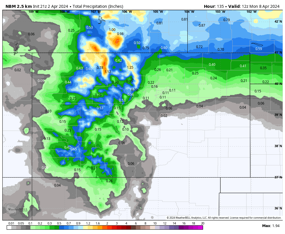
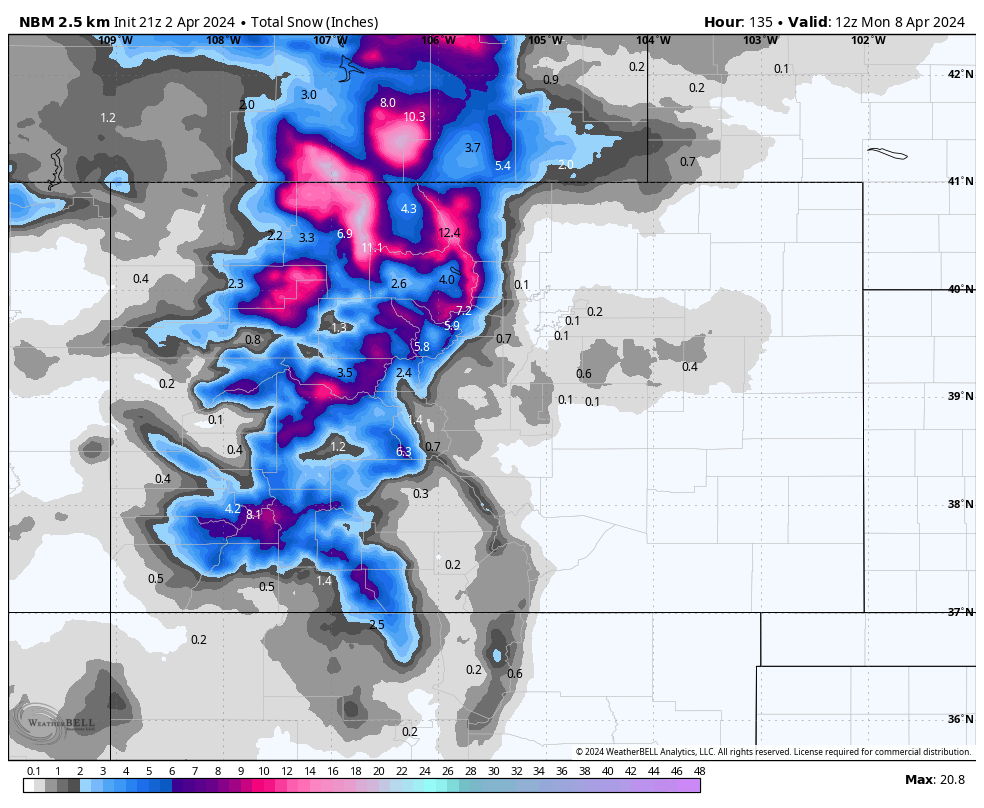
Winds… Friday gusts in the valley will be 35-45mph and gusts in the mountains will be 55-65mph. The winds will let up a little bit on Saturday with gusts of 25 to 35mph in the valley and the mountains.
Temps… Highs Friday will be in the low to high 50s and lows Friday night will be in the high 20s to mid-30s. Highs Saturday will be in the mid-30s to low 40s and lows Saturday night will be in the low-teens to high-teens. Brrrrr!
Sunday will be partly to mostly cloudy as the low exits to the east with just a few isolated snow showers over the mountains. Highs on Sunday will be in the low 40s to upper 40s.
We’ll continue to adjust the details as the data gets better.
A second area of low pressure will impact us on Monday. I’ll have all the details on that in my next report on Thursday.
Wolf Creek has announced on their web page that their last day of operations will be Sunday, April 7th.
– Arleen


