

Morning glow on Cimarrona – pic taken 3/23/2024
If images fail to load in the email, please click the title of the post. Thanks!
Saturday – 23 Mar 2024 – 2:00pm
The past…
At Stevens Field the high temperature yesterday afternoon was 57 and the low this morning was 37.
The peak wind at the airfield yesterday was 20mph.
| Average High | Record High / Year | Average Low | Record Low / Year |
| 51 | 73/ 1940 | 19 | -5 / 1952 |
Precipitation summary… There has been no recent measurable precip.
Forecast discussion…


Forecast highlights…
*** A WINTER WEATHER ADVISORY is out for the eastern San Juan Mountains above 10,000ft for up to 18” of snow and winds gusting to 55mph valid 6pm Saturday to 6pm Monday. ***
*** Travel conditions will be sketchy, especially in the mountains, Saturday night into Monday. ***
*** Expect significantly colder temperatures starting on Sunday – Winter will be back!***
Saturday: Clouds will continue to increase ahead of the next system. The first few scattered showers will start over the mountains late Saturday afternoon and over the valley late Saturday evening.
The snow level will start around 8,700ft Saturday afternoon, drop to around 8,000ft by midnight, and then continue to drop to around 7,000ft by sunrise Sunday.
Most areas in the valley will see rainshowers first, and then switch to snow overnight. Precip will be spotty most of the night and then become more widespread by sunrise Sunday.
Snow amounts Saturday afternoon to sunrise Sunday…
Valley: up to 1”
Mountains: 3-6”
Winds… Gusts late Saturday afternoon and evening will be out of the southwest 20-30mph.
Temps… Highs Saturday will be in the low to high 50s and lows will be in the high 20s to mid-30s.
Sunday: The best chance for snow and an isolated thunderstorm is sunrise to late afternoon Sunday.
Snow levels will be around 6,500ft through Sunday afternoon and then drop below 6,000ft after sunset. Temps will be above freezing so snow will struggle to accumulate. Spotty showers will persist through Sunday night.
Winds… Peak gusts will be 20-25mph.
Temps… Highs Sunday will be in the mid to high 30s and lows will be in the low to high 20s.
Snow amounts sunrise Sunday to sunrise Monday…
Valley below 7,600ft: 1-3”
Valley above 7,600ft: 2-5”
Mountains: 6-10”
Winds… Gusts will be 20-25mph.
Temps… Highs Sunday will be in the mid to high 30s and lows Sunday night will be in the low to high 20s.
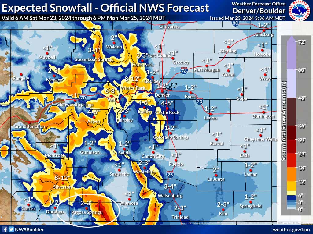
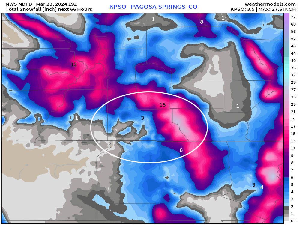
Monday and Tuesday… Unsettled conditions will persist with residual moisture and instability leading to mostly cloudy skies and scattered afternoon showers and maybe even a thunderstorm. Precip amounts will be light and spotty.
Snow amounts sunrise Monday to Tuesday evening…
Valley: up to 1” in the lucky spots each afternoon
Mountains: 1-3” each day but it will be spotty
Winds… Afternoon gusts will be 15-20mph.
Temps… Highs will be in the mid-30s to low 40s and lows will be in the low teens to low 20s.
Wednesday, Thursday, and Friday… Wednesday will be dry with partly cloudy skies as an upper-level ridge moves through.
Thursday and Friday there will be a few more clouds and a slight chance for spotty afternoon showers as upper-level flow increases out of the southwest ahead of the next system. Precip amounts will be minimal and very spotty.
Temps and winds will gradually increase through the period.
Winds… Afternoon gusts Wednesday will be 15-20mph. Afternoon gusts Thursday and Friday will be 20-30mph.
Temps… Highs Wednesday will be in the low to high 40s and lows will be in the mid-teens to mid-20s. Highs Thursday and Friday will be in the mid-40s to mid-50s and lows will be in the low 20s to low 30s.
I’ll probably do a quick Facebook post first thing Sunday morning and then a more thorough forecast post later Sunday morning.
– Shawn


