We have been busy behind the scenes analyzing our future weather and what is in store for us this winter. After TWO abysmal winters, this one has got to be better!
Josh Pike from the Pagosa Sun reached out to us last week and interviewed us about what our thoughts are for this upcoming winter. His article with our thoughts and those of Grand Junction National Weather Service meteorologist Matthew Aleska were on the front page of this week’s paper. It was good to see the Matthew’s analysis is in line with ours. And they are both positive! Pagosa Sun “Will the Super El Nino Bring Super Snow” article by Josh Pike.
Winter Weather Wonder
For a detailed personal explanation of our winter forecast, attend our Winter Weather Wonder event Friday, November 13th, 5:30pm to 8:30pm, at the Pagosa Lakes Clubhouse 230 Port Avenue.
Pagosa Weather, as the NWS Weather Ready Nation Ambassadors, will put on the 2nd annual Winter Weather Wonder in order to help the community prepare for winter. Everyone is invited to this FREE event!
Dustin English with the Upper San Juan Search and Rescue will be the guest speaker. Shawn and I will speak about this winter’s forecast and the influence of the Super El Nino.
Upper San Juan Search and Rescue, Colorado Avalanche Information Center (CAIC), Archuleta County CSU Extension Agent Cindi Galabota, The Pagosa Springs Fire Department, The Springs Resort, and Peggy Andrews will have information booths there.
We will pass out free snow windshield wiper brushes.
Hors d’oeuvres will be catered by Farrago Events and Chefs Todd and Kellie Stevens. A selection of winter cookies will be baked by Tracey. Kenny Rogers and the Pagosa Mountain Rotary Club will be manning a wine and beer bar. All proceeds go towards their community initiatives. We’ll have free nonalcoholic beverages selections as well.
We look forward to an evening talking about everything winter and SNOW!
Winter Outlook Slide Show
We used the following slides to brief Josh Pike of the Pagosa Sun yesterday. I’ve added short explanations. I’ll have the full forecast out in November with full explanations and more winter information including the arctic oscillation and the MJO forecasts. You can review the full winter outlook from last year for more information on the ENSO pattern and the QBO. LAST YEARS winter outlook.
When we look at seasonal forecasts, we look at below average, average or above average precipitation and temperatures. So what is average?
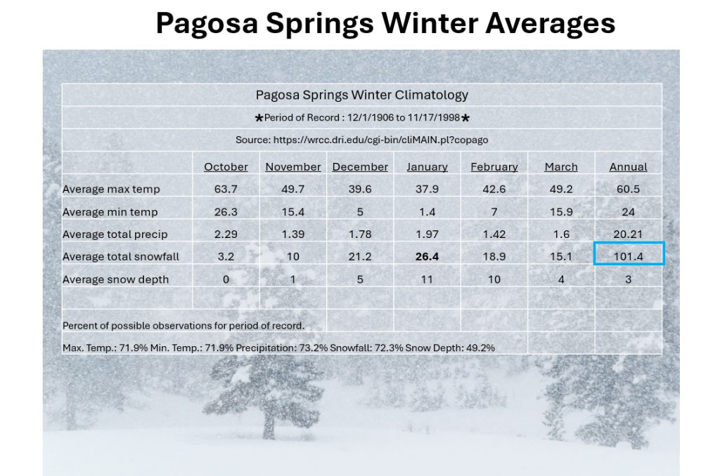
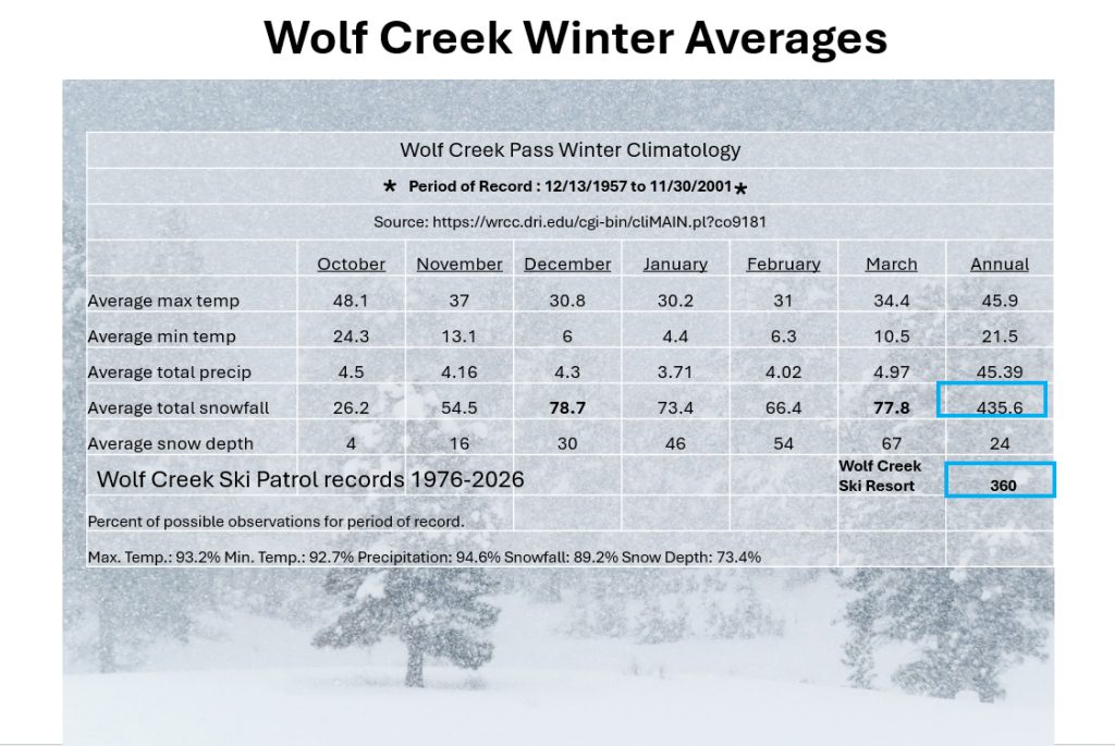
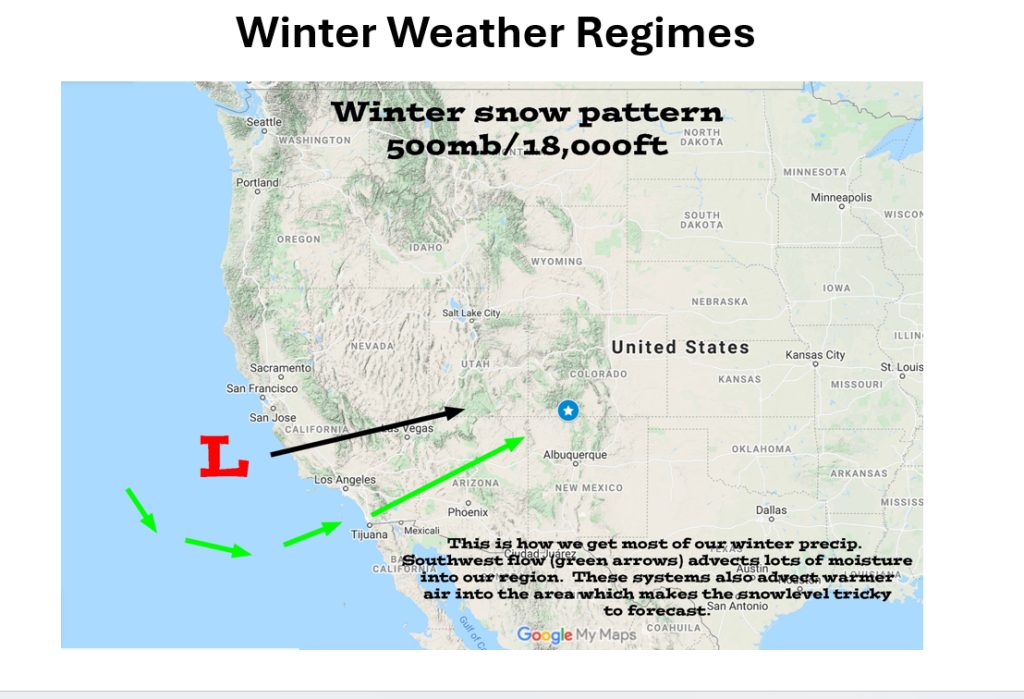
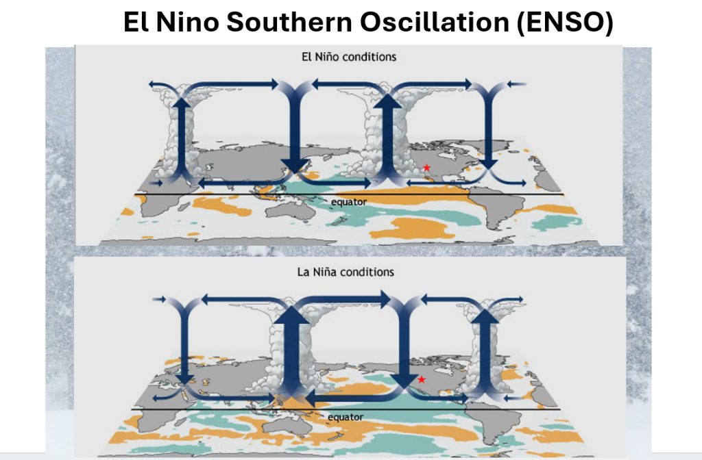
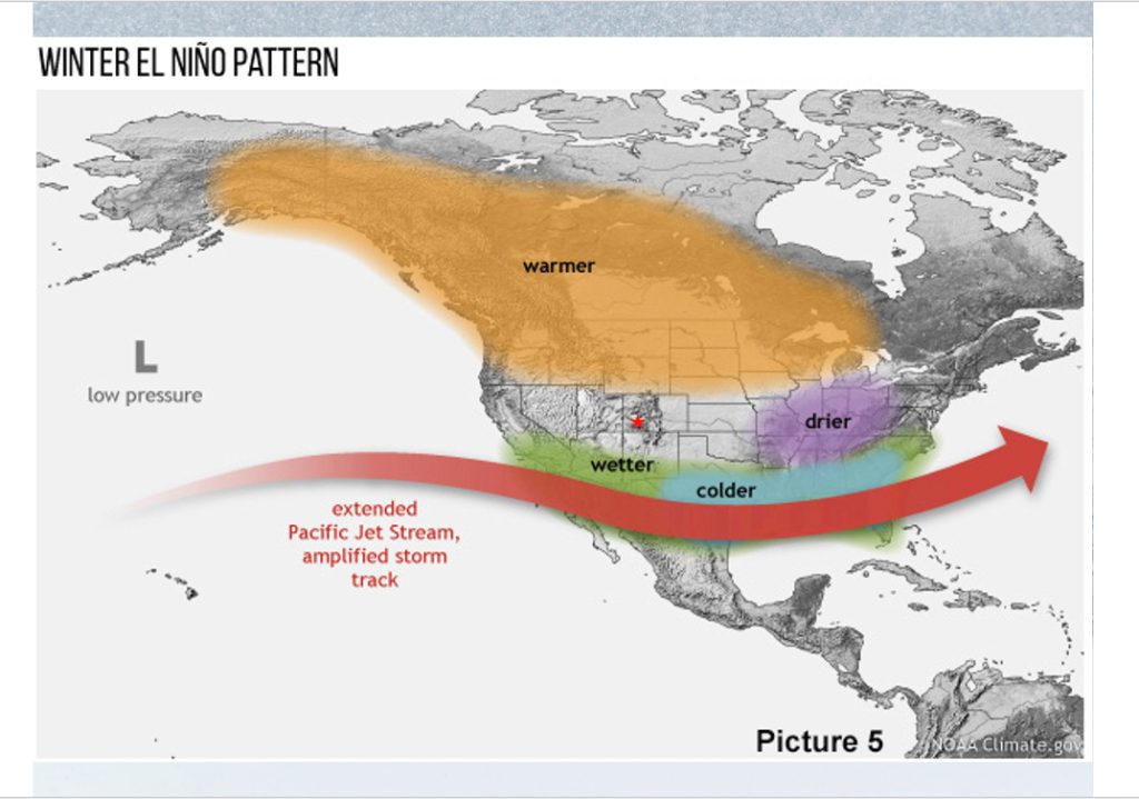
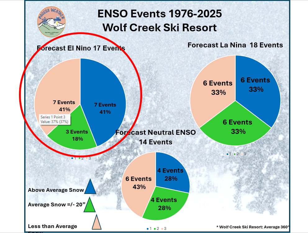
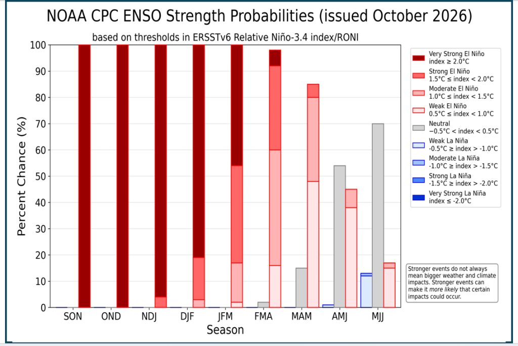
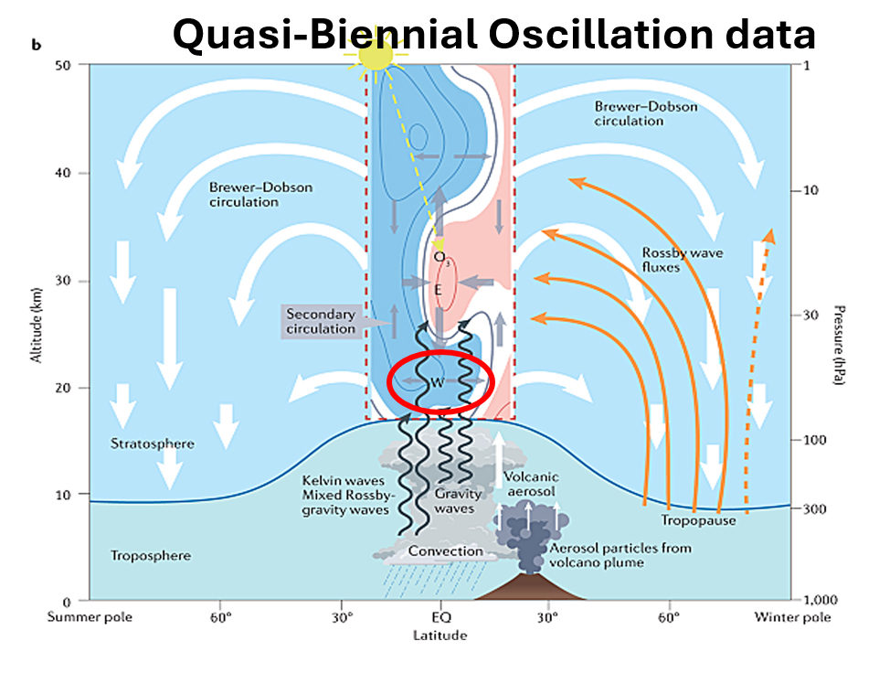
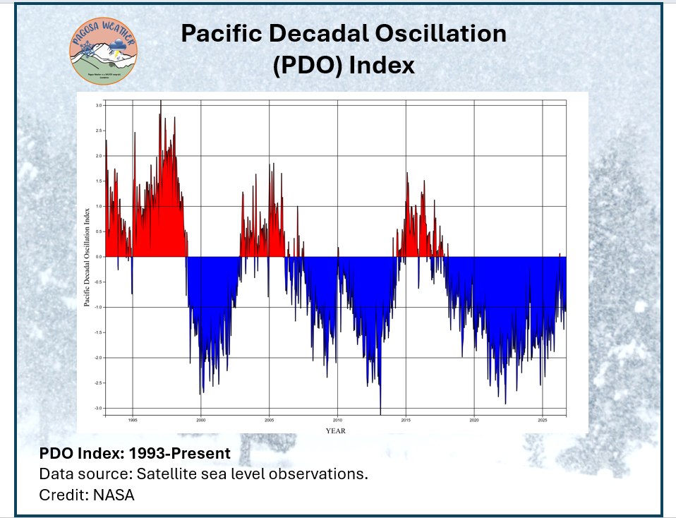
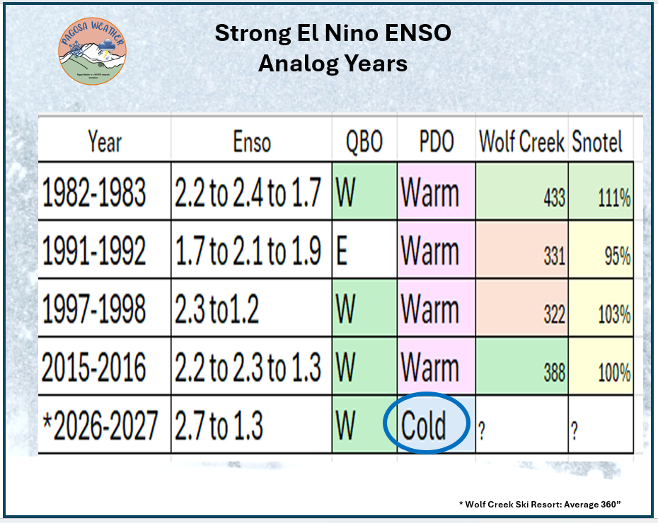
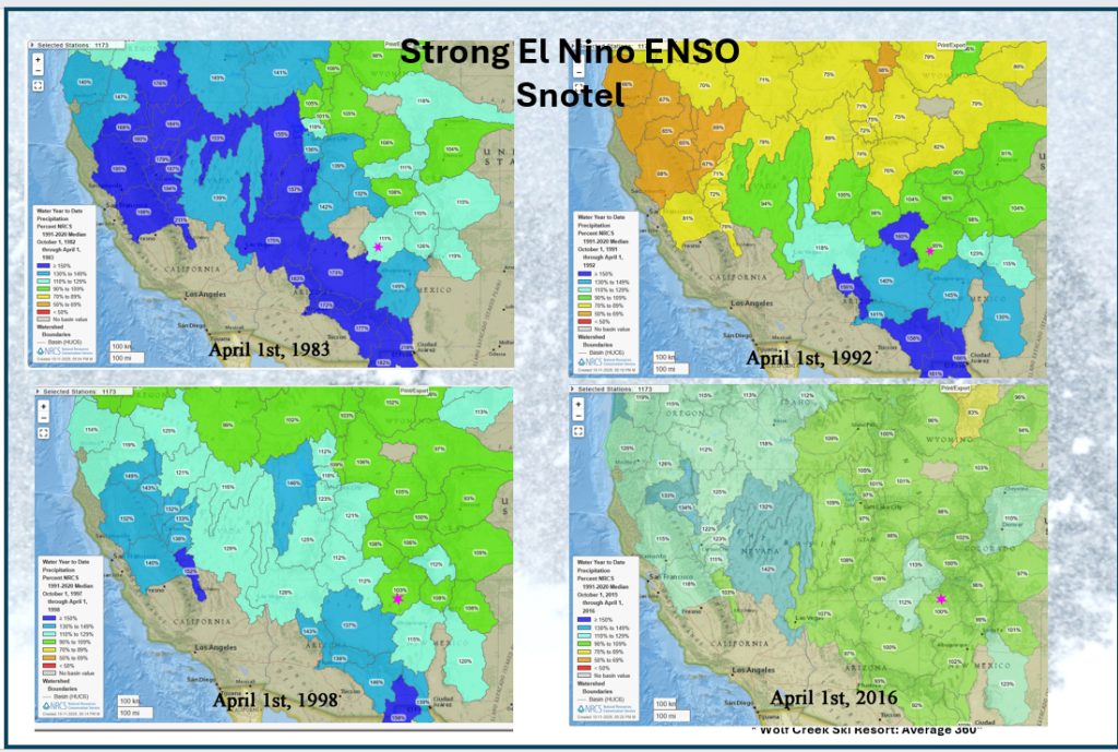
Pagosa Springs sees an average of 101′ of snow each winter. A few caveats here. These records were only till 1998 – 28 years ago! Stevens Field, the official observation site, has not been measuring snow or measuring precipitation since then. Also those years include a few years of Wolf Creek Snow and a few years the snow was measured up at Palisades Lakes. That skewed the numbers.Wolf CreekPass averages 435″ of snow a year. This data also has a few caveats. Someone lived on the Pass and measured the snow till 2001. That data has a lot of asterisks when the observer was gone for 30 days or more. We have a newer set of data from the ski patrol at Wolf Creek Ski resort. They are reliable and measure every day… that the ski resort is open. So they miss early season snow and late season snow. April of 2026 had about 50″ of snow and that didn’t count toward the seasonal total. They average 360″ of snow where they measure. Our ideal snow pattern is a Low pressure off the coast of California that moves east across Arizona and New Mexico pushing up moisture ahead of it and pulling cold air in behind. The ENSO is the primary oscillation we track since it impacts the northern hemisphere, is predictable up to a year in advance and is usually accurate. The ENSO forecast for this winter is an El Nino pattern which results in enhanced systems over the eastern Pacific. El Nino results in a stronger Polar Front Jet that has a more southerly track with wetter and colder conditions across the southern United States. Pagosa Springs can be north of that pattern.Historically we have had 17 El Nino events since 1976. Seven events were more than average snow, three were average and seven were below average! Just flip a coin! Not only is this winter an El Nino winter, it is a “Super” or Very Strong El Nino. The temperatures in the Pacific equatorial areas are 2C above average. This will persist through January (DJF). The temperatures will be cooler by March and Neutral by May. Another Oscillation we track closely is the Quisi-Biennial. It is a stratospheric wind that switches from westerly to easterly every other winter. So it is easy to forecast years in advance. When it is westerly, it is faster and in turn the Polar front jet tends to be stronger and systems tend to be deeper and airmasses colder. We don’t normally talk about the Pacific Decadal Oscillation. It is a long-term ocean-atmosphere climate pattern in the Pacific Ocean north of 20°N that shifts through warm and cool phases every 20 to 30 years. It has been in a cool phase for almost 7 years. It works in conjunction to enhance or weaken the affect of the ENSO. The data for Wolf Creek Ski Resort and Snotel data located near Wolf Creek Pass during years we had a strong El Nino. The winter of 1982/1983 has a big ole asterisk next to it since on May 18th 1980 Mt St Helen’s blew and cooled the earth as a whole leading to a few years of deeper snowpacks through the entire inter mountain west. The high tub marks on Lake Meade and Lake Powell are from 1983 and those few years of snow.
Winters with strong El Nino and westerly QBO (97/98 and 15/16) were average to below average snow years despite Super El Nino. What?
NOTE: The difference this year, is that cold PDO.If we look at the whole picture, we see on strong El Nino winters, areas south of us do much better. The influence of the strong El Nino increases the strength of the storm track but also carries it south.
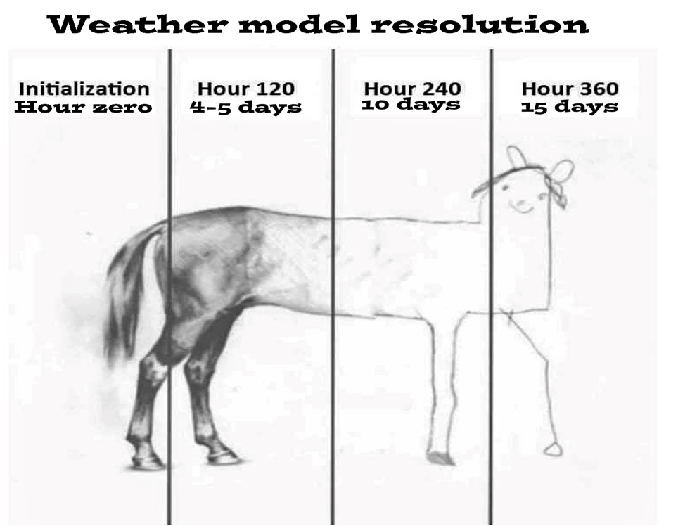
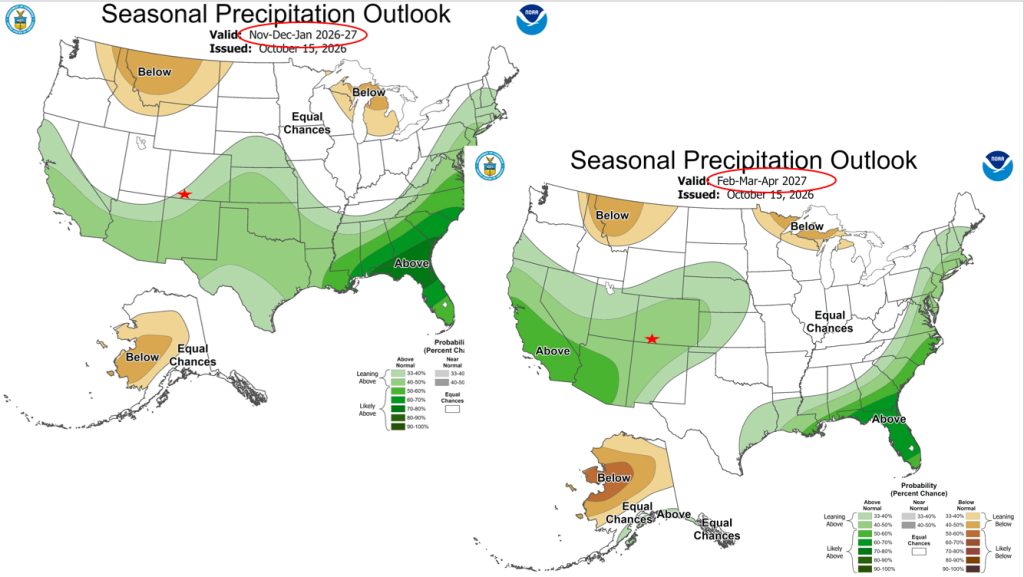
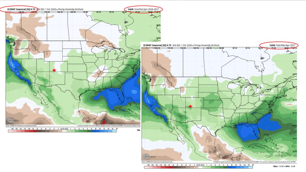
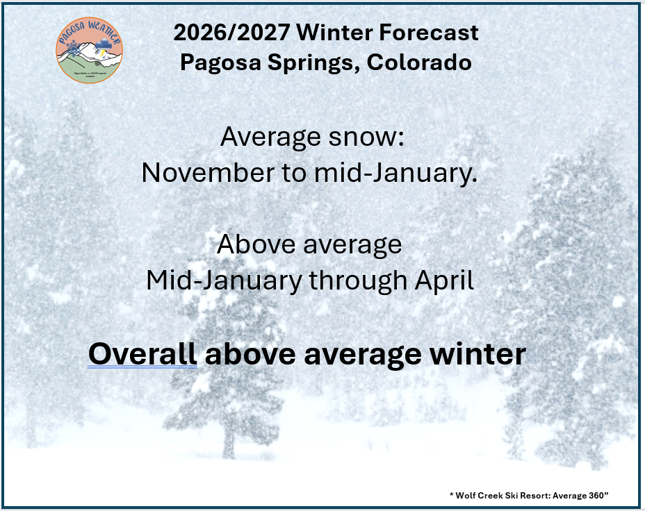
Ski areas that often are not able to even open in New Mexico, should have a good early winter! We’ll take a look at some of the model data and what they are forecasting and then we’ll look at the Pagosa Weather forecast for this winter. Keep in mind the farther out the forecast, the fuzzier it can become. The Climate Prediction Center (CPC) is “leaning above” probability of above average snow for November, December, and January. Then a better probability of for the months of February, March and April for most of the state of Colorado. The Euro model is in agreement with the CPC forecast. The winter will start with the stronger storm track to our south. The cooler PDO will negate some of the influence of the strong El Nino and that will result in average snow for the Archuleta County area, Pagosa Springs, and Wolf Creek. Our temperatures will be below average so the snows that fall should be lighter and we will not see as much rain as in years past. As we move into January, the strong El Nino will weaken. The storm track will be over our heads. February, March and April should see above average snows. Overall we should have above average snows for the winter.
Again, our full detailed winter forecast will be out in November when we have more data. Also, for a detailed personal explanation of our winter forecast, attend our Winter Weather Wonder event Friday, November 13th, 5:30pm to 8:30pm, at the Pagosa Lakes Clubhouse 230 Port Avenue.
I grew up in Montana where my love of the mountains is rooted. I served in the Air Force, forecasting aviation weather, for 24 years. I had eight assignments and my favorites were Colorado, Alaska, Korea, and Germany. I deployed several times, including to Iraq and Afghanistan. After RV traveling for nine years, Shawn and I found paradise in Pagosa. Here we enjoy playing outside in the spectacular San Juan mountains!
Pagosa Weather Disclaimer and Release of Liability
This website makes no guarantees about nor bears any responsibility or liability concerning the accuracy or timeliness of the weather information published on this website. All weather information published on this website is for educational and weather enthusiast purposes only. We do not issue Storm Watches, Warnings or Advisories as that ability falls with the National Weather Service, who is the only institution allowed to issue such warnings by law. We are not in any way linked nor affiliated with the National Weather Service, although we do share information and relay weather watches/ warnings, etc. Use of the information on page is at your own risk/discretion, and we are not responsible for any personal/property damages, injury or death associated with weather forecasts, reports or other information as well as communication exchanged in private messages and/or person.