Pagosa Weather AUGUST SUMMARY & September Outlook

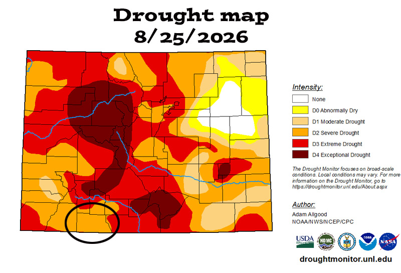
"Severe drought" conditions persist across Archuleta County.

“Severe drought” conditions persist across Archuleta County.

Wednesday – 2 Sep 2026 – 7:15am

August summary…

The average high for August is 80 and the average low is 45. The record high of 97 occurred on 5 August 1940. The record low of 28 occurred on 30 August 1978. Precip in August averages 2.69″ and the average snowfall is zero. Wolf Creek Pass averages 4.32″ of precip and zero snow.

At Stevens Field the highest temp was 92 on 6 and 7 Aug and the lowest temp was 44 on 16 Aug. There were two new record highs set on 6 and 9 Aug.

There were 10 days with winds at or over 30mph. The highest wind was 40mph on 10 Aug.

How did we do?
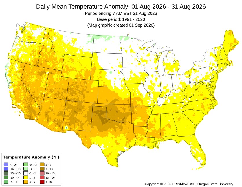
August mean temperature anomalies across much of Archuleta County were 5-7 degrees above average.
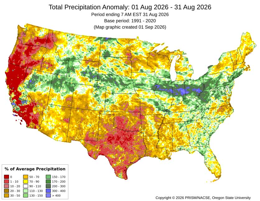
August mean precip anomalies – Most of the county got 20% to 50% of average.
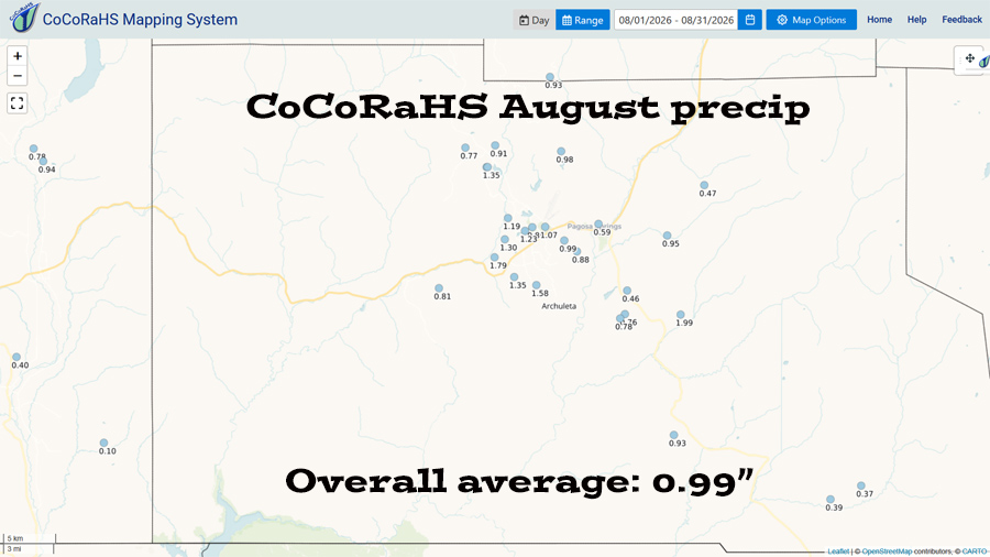
CoCoRaHS precip totals ranged from 0.37″ to 1.99″. All locations were below the average of 2.69″.
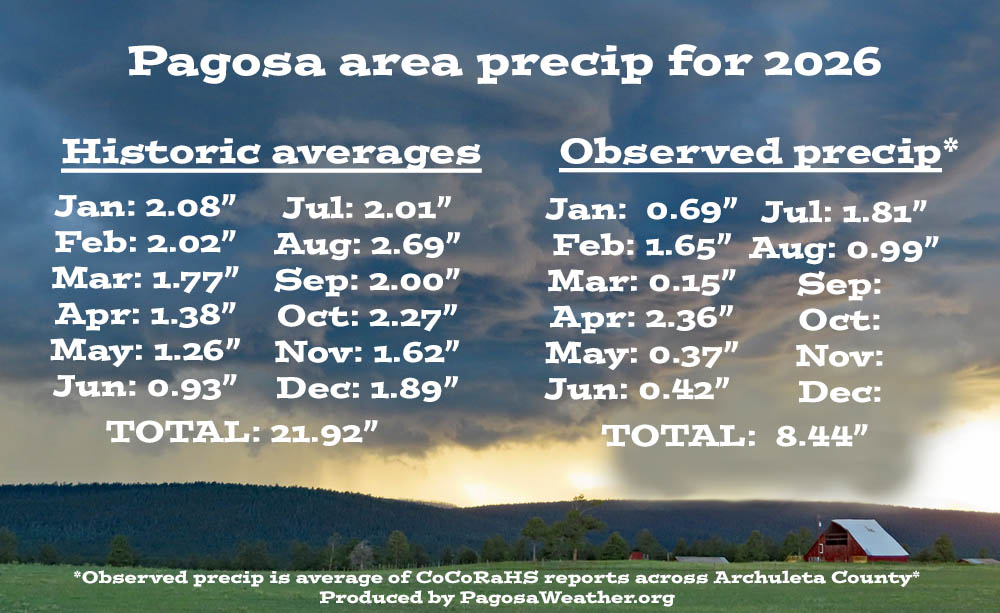
Total precip so far in 2026 is 8.44 – 60% of the average of 14.14″.

Drought and river levels…

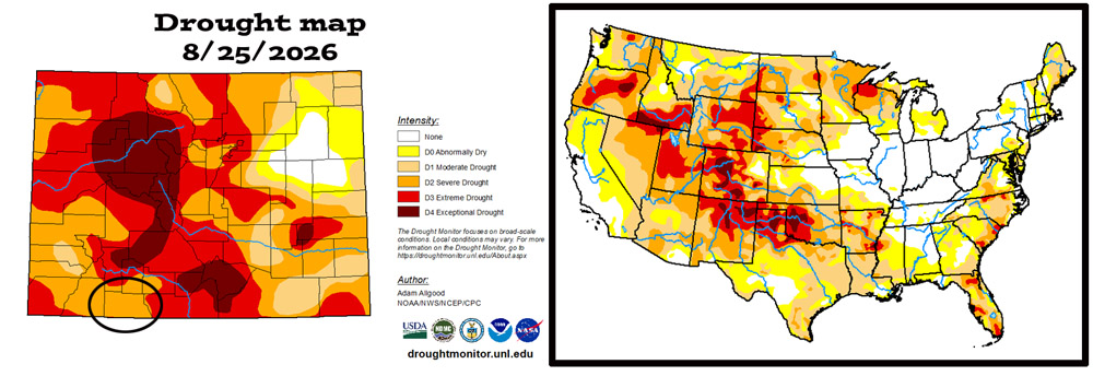
"Severe drought" conditions persist across Archuleta County.
The US drought map on the right shows that much of the US is experiencing drought conditions.
“Severe drought” conditions persist across Archuleta County.
The US drought map on the right shows that much of the US is experiencing drought conditions.
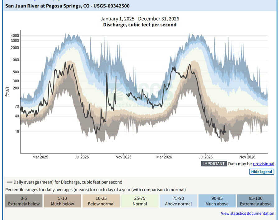
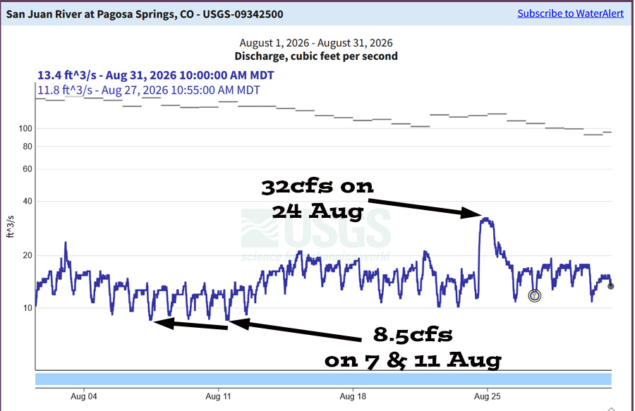
Flow was well below the mean the entire month. In August we normally see a few big monsoon induced spikes.
Flow was well below the mean the entire month. In August we normally see a few big, monsoon induced spikes.
Flow is currently less than 5% of average.

September outlook…

The average high for September is 74 and the average low is 37. The record high of 98 occurred on 6 September 1955. The record low of 15 occurred on 27 September 1908. Precip in September averages 2.00″ and the average snowfall is a trace. Wolf Creek Pass averages 4.26″ of precip and 4″ snow.
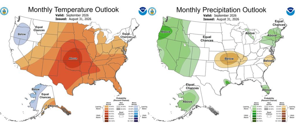
The CPC temp outlook for September on the left shows a 40-50% chance for above average temps.
The precip outlook on the right shows a 33-40% chance for above average precip.
The CPC temp outlook for September on the left shows a 40-50% chance for above average temps.
The precip outlook on the right shows a 33-40% chance for above average precip.
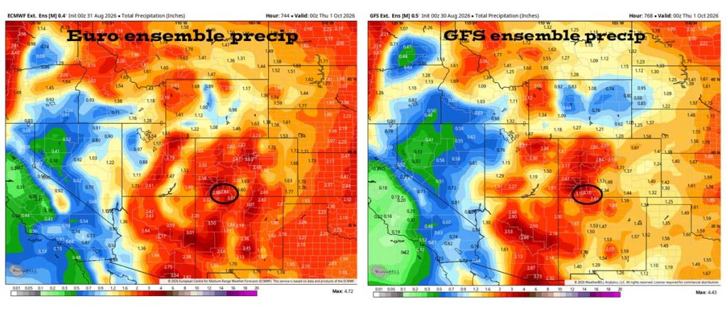
Euro ensemble precip on the left expects 2.84″ for September and the GFS ensemble precip on the right expects 3.10″. Both models expect more than the average of 2.00″.
August verification: The Euro expected 3.95″ and the GFS expected 3.85″. We got 0.99″ so both models over-forecast precip.
Euro ensemble precip on the left expects 2.84″ for September and the GFS ensemble precip on the right expects 3.10″. Both models expect more than the average of 2.00″.
August verification: The Euro expected 3.95″ and the GFS expected 3.85″. We got 0.99″ so both models over-forecast precip.

Arleen’s September outlook…

Welcome to meteorological fall! We’re also heading into the last month of monsoon season.

The earth starts to tilt away from the sun, so we see general cooling. With that the subtropical ridge that supports our monsoon flow weakens. However, the eastern Pacific waters are warm and open for business. We’ve already seen a few tropical storms and hurricanes in the eastern Pacific. With the long wave trough hanging out to the west, it is just a matter of time before some remnant tropical moisture gets picked up and swept northeast into our area.

The subtropical ridge is currently to our east and will remain strong till the mid-month point. The second week of September could be the best precipitation producing week of the monsoon season. However, the ridge will weaken after that and so will the rain produced.

We can expect to see tropical cyclone moisture at least once, during the final two weeks of the month and that will put us up to average moisture for the month.

The longwave trough to the west will temper our temperatures which will keep us near average for the month. It will be nice to have those hot days behind us.

Finally, with the long wave trough hanging out to the west, a cold front is likely to slip southeast at the end of the month bringing our first few snowflakes, especially up at Wolf Creek!

A HUGE thanks for your precip reports and pictures! Reports help verify our forecasts and make us better forecasters.

Another HUGE thanks to our donors and sponsors! You help cover the cost of this web page and our weather subscriptions, necessary to provide you accurate weather reports!

  • Shawn

Pagosa Weather Blizzard Level Sponsor

Pagosa Weather Storm Sponsor

Picture of Shawn Pro

Shawn Pro

I’ve been a “weather geek” since I was young child. I joined the military out of high school and was lucky to get my dream job in weather. I have 20 years of military weather experience which includes forecasting the weather all over the world. Highlights were six years in Alaska and making life and death weather decisions during deployments. I love mountains, I love snow, and I love summertime thunderstorms. I spend a bunch of time playing outdoors and found my paradise in Pagosa Springs. I do Pagosa Weather as a community service. Hopefully you find us helpful!

Leave a Reply

Your email address will not be published. Required fields are marked *

Pagosa Weather Disclaimer and Release of Liability

This website makes no guarantees about nor bears any responsibility or liability concerning the accuracy or timeliness of the weather information published on this website. All weather information published on this website is for educational and weather enthusiast purposes only. We do not issue Storm Watches, Warnings or Advisories as that ability falls with the National Weather Service, who is the only institution allowed to issue such warnings by law. We are not in any way linked nor affiliated with the National Weather Service, although we do share information and relay weather watches/ warnings, etc. Use of the information on page is at your own risk/discretion, and we are not responsible for any personal/property damages, injury or death associated with weather forecasts, reports or other information as well as communication exchanged in private messages and/or person.

Terms of Use                  Privacy Policy

© 2026 Pagosa Weather 

Website Design by : Brandon