Scattered soaking storms Wednesday, Thursday, and Friday…

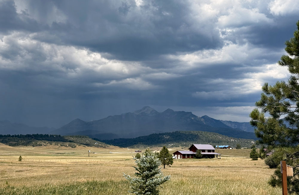
Storm over Pagosa Peak Tuesday afternoon – pic taken 8/11/2026

Storm over Pagosa Peak Tuesday afternoon – pic taken 8/11/2026

Tuesday – 11 Aug 2026 – 4:15pm

The past…

Stevens Field Observations

Sunday: High: *91*, Low: 52, Peak wind: 38mph, Afternoon humidity: 9-14%

Monday: High: 89, Low: 52, Peak wind: 40mph, Afternoon humidity: 15-20%

* New record high beat previous record high of 90 set in 1969.*

Average HighRecord High / YearAverage LowRecord Low / Year
8194 / 19404532 / 1974

Precipitation summary… A few lucky folks got a soaking Monday afternoon.
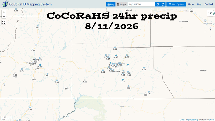
CoCoRaHS 24-hour precip reported Tuesday morning ranged from zero to 0.49”. Most folks reported less than 0.10”.

Current satellite, radar, and smoke…
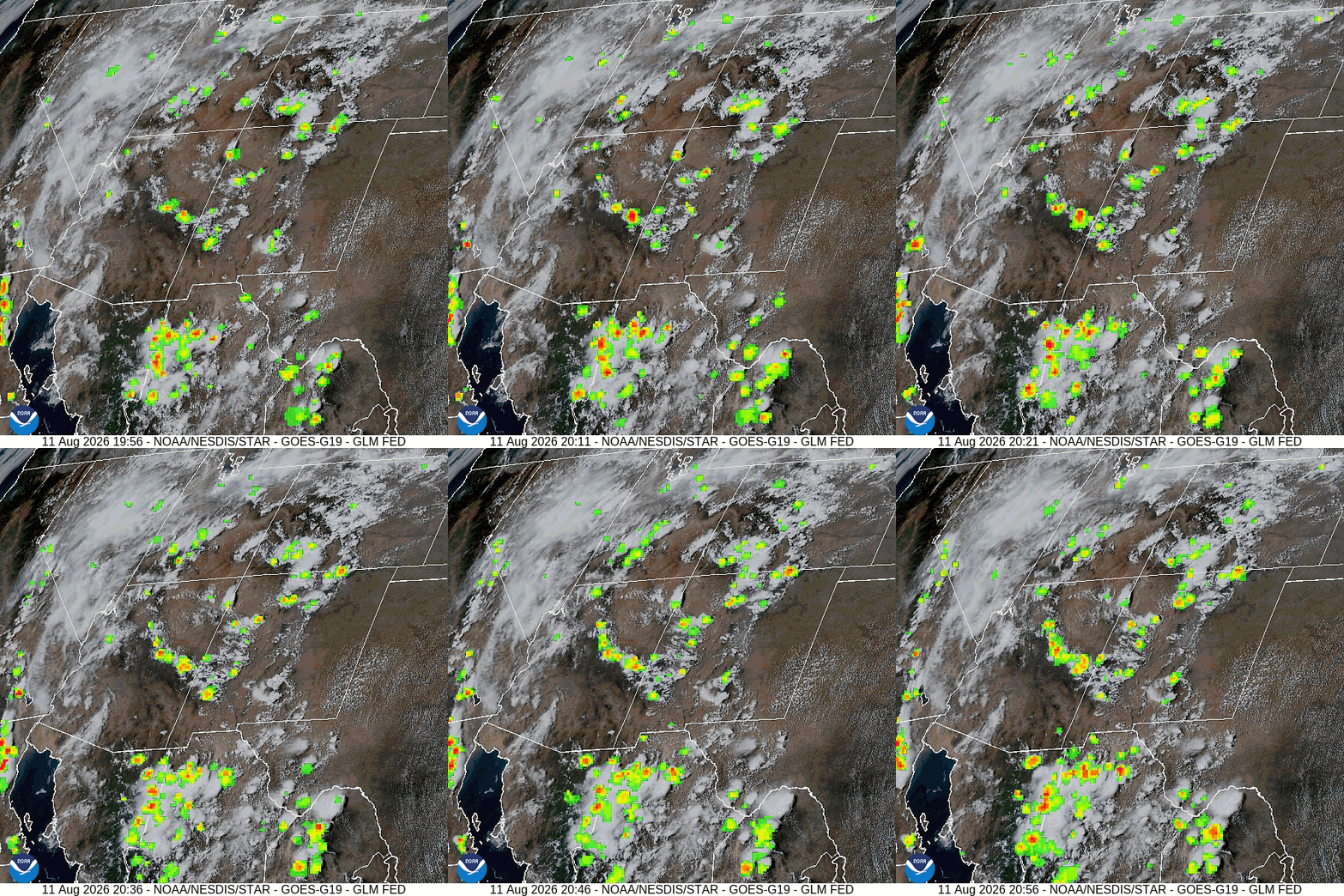
Visual satellite and lightning loop from 2pm to 3pm Tuesday – The high is just to our south. Monsoon moisture and instability has increased over our area. There has been quite a bit of lightning over the San Juans this afternoon.
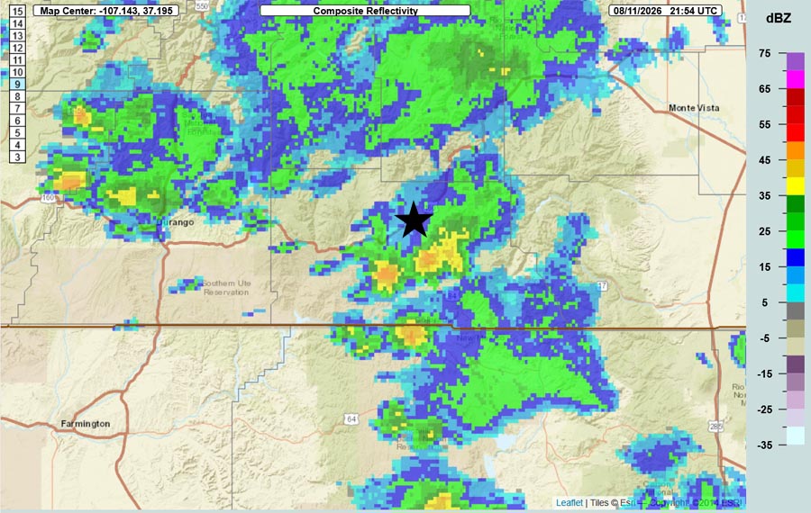
Radar at 3:54pm Tuesday – Scattered showers and thunderstorms are “slow movers” that are soaking small areas. The star is over Pagosa Springs.
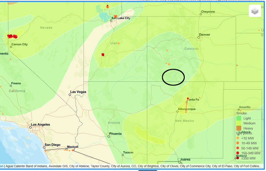
The smoke map on Tuesday afternoon shows “light” smoke over us. Air quality was “moderate” into Monday evening and has been “good” since.
The smoke map on Tuesday afternoon shows “light” smoke over us.
Air quality was “moderate” into Monday evening and has been “good” since.

Forecast highlights…

*** Fire danger remains high. Warm, breezy afternoons have dried things out. The San Juan National Forest and Archuleta County are under stage 1 fire restrictions. ***

 *** There will be hit and miss storms each afternoon and evening. Some of these storms will be soakers. The most favorable days for a good soaking are Wednesday, Thursday, and Friday. Saturday and Sunday there will be a brief lull with less activity, and then it will ramp up again. Do your rain dances! ***

*** Rio Blanco Fire… Thanks to the efforts of everyone tackling the fire, containment is 91% and property owners have returned! For the most current information follow Archuleta County, CO Sheriff’s Office or Rio Blanco Fire on Facebook or Watch Duty. ***

Rest of Tuesday through next Tuesday… The subtropical high will finally move to our east – where we want it! Monsoon moisture and instability will increase. There will be scattered storms each afternoon and evening.

The most favorable days for a good soaking are Wednesday, Thursday, and Friday. Saturday and Sunday there will be a brief lull with less activity, and then it will ramp up again.

Storms Wednesday, Thursday, and Friday will be capable of producing heavy rain, small hail, gusty winds, poor visibility, and lightning over small areas for short periods.

Temps…

Tuesday night lows will be near 50 to the mid 50s.

Wednesday highs will be near 80 to the high 80s and lows will be near 50 to the mid 50s.

Thursday through the weekend highs will be in the mid 70s to the low 80s and lows will be near 50 to the high 50s.

Monday and next Tuesday highs will be in the high 70s to the mid 80s and lows will be in the in high 40s to the mid 50s.

Winds…

Each afternoon gusts will be around 20mph though isolated stronger gusts are likely near showers and thunderstorms.
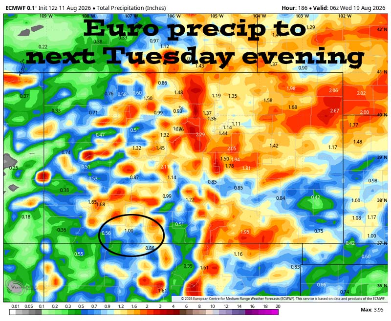
Euro precip to next Tuesday evening (18 Aug) shows 1.00” in the Pagosa area and up to 2.00” in our mountains. The best chance for storms is Wednesday, Thursday, and Friday. Any single storm will be capable of producing heavy rain over a small area.

18 Aug to 26 Aug… The subtropical high will wobble between the Four Corners area and the TX/OK panhandle area. When it’s near the Four Corners, it’s marginal for us, but when it’s to the east, it’s game on. I expect the pattern to stay active for us with scattered storms each afternoon and evening.
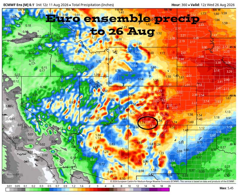
Euro ensemble precip to 26 Aug shows 2.09” in the Pagosa area. Forecast precip amounts have down a little over the last two days. Much of Colorado should get a soaking over the next two weeks.
Euro ensemble precip to 26 Aug shows 2.09” in the Pagosa area.
Forecast precip amounts have trended down a little over the last two days.
Much of Colorado should get a soaking over the next two weeks.
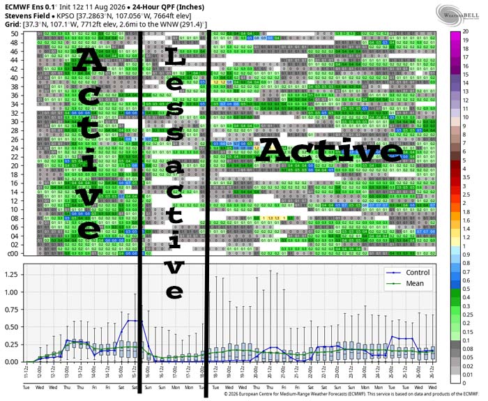
This is Euro ensemble 24-hour precip amounts for the Pagosa Springs area to 26 Aug. It’s read left to right, and times are in Zulu. The top chart shows 24-hour precip amounts for 50 versions of the Euro forecast model. The bottom chart graphs the control, mean, and range of the 50 versions. It’s active Wednesday, Thursday and Friday. There’s a brief lull with less activity over the weekend and then it’s a little more active through the rest of the period.
This is Euro ensemble 24-hour precip amounts for the Pagosa Springs area to 26 Aug. It’s read left to right, and times are in Zulu. The top chart shows 24-hour precip amounts for 50 versions of the Euro forecast model. The bottom chart graphs the control, mean, and range of the 50 versions.
It’s active Wednesday, Thursday and Friday. There’s a brief lull with less activity over the weekend and then it’s a little more active through the rest of the period.

The next post will be Thursday afternoon.

– Shawn

Pagosa Weather Blizzard Level Sponsor

Pagosa Weather Storm Sponsor

Picture of Shawn Pro

Shawn Pro

I’ve been a “weather geek” since I was young child. I joined the military out of high school and was lucky to get my dream job in weather. I have 20 years of military weather experience which includes forecasting the weather all over the world. Highlights were six years in Alaska and making life and death weather decisions during deployments. I love mountains, I love snow, and I love summertime thunderstorms. I spend a bunch of time playing outdoors and found my paradise in Pagosa Springs. I do Pagosa Weather as a community service. Hopefully you find us helpful!

One Response

  1. Shawn and Arlene, what kind of rain amounts do we need for the SJ river and its tributaries to recover to decent volume?
    Thanks!
    Tyler Shepperd

Leave a Reply

Your email address will not be published. Required fields are marked *

Pagosa Weather Disclaimer and Release of Liability

This website makes no guarantees about nor bears any responsibility or liability concerning the accuracy or timeliness of the weather information published on this website. All weather information published on this website is for educational and weather enthusiast purposes only. We do not issue Storm Watches, Warnings or Advisories as that ability falls with the National Weather Service, who is the only institution allowed to issue such warnings by law. We are not in any way linked nor affiliated with the National Weather Service, although we do share information and relay weather watches/ warnings, etc. Use of the information on page is at your own risk/discretion, and we are not responsible for any personal/property damages, injury or death associated with weather forecasts, reports or other information as well as communication exchanged in private messages and/or person.

Terms of Use                  Privacy Policy

© 2026 Pagosa Weather 

Website Design by : Brandon