Just sprinkles this week. Monsoon returns next week.

Sunset

Cumulus/altocumulus make for spectacular sunsets! Photo Credit to Bryan – pic taken 7/26/2026

Monday – 3 Aug 2026 – 7:45pm

The past…

Stevens Field Observations

Sunday: High: 91, Low: 50, Peak wind: 23mph, Afternoon humidity: 13-17%

Monday: High: 91, Low: 50, Peak wind: 32mph, Afternoon humidity: 10-15%

Average HighRecord High / YearAverage LowRecord Low / Year
8294 / 19404634 / 1975

Precipitation summary… There were a few showers in the area Saturday evening.
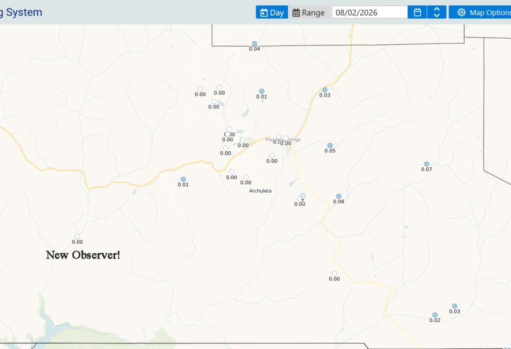
CoCoRaHS 2 Aug 26
Precip reports from Sunday Morning for rain that fell Saturday evening. Leo on CatchPole was the rain lottery winner with .08. Ricky on Upper Blanco reported .07″. Welcome to Brooke on the western frontier!

Current satellite and radar…

Sat
Water vapor satellite Monday at 7:20pm – The high is to our west and has cut off monsoon moisture. Flow around the high is indicated by the blue arrows. Flow over us is out of the northwest which is not conducive to good monsoon showers anyway.

There are not any radar reports near us this evening. Rainshowers in San Luis Valley are moving from the northwest to the southeast.

Forecast highlights…

*** Fire danger remains high. Warm, breezy afternoons are drying things out. The San Juan National Forest and Archuleta County are under stage 1 fire restrictions. ***

 *** Spotty showers storms each afternoon and evening. ***

*** Rio Blanco Fire: 1,140 Acres. For the most current information follow Archuleta County, CO Sheriff’s Office or Rio Blanco Fire on Facebook and the Watch Duty app. ***

This week… The subtropical High will remain to our west till this weekend. Over the weekend it wobbles over the four corners area. By Sunday evening it should be to our east where it belongs for a good monsoon pattern. It will take a few days for it to pick up good moisture.

Monsoon moisture and instability will increase a little. There will be a few hit and miss storms most afternoons and evenings. It’s weak. Expect only a few sprinkles. Best chance is over the weekend.

Temps…

Lows: Upper 40s to Low 50s.

Highs: Upper 80s to Low 90s. We could break records on Thursday: 91 set in 1981, Saturday & Sunday: 90 set in 1969.

Winds…

Monday, Wednesday, Friday, Saturday, Sunday afternoon gusts will be around 20mph though isolated stronger gusts are likely near showers and thunderstorms. Tuesday afternoon gusts to 25mph. Thursday as the gradient tightens expect evening wind will gusts to 30mph from 6pm till midnight.
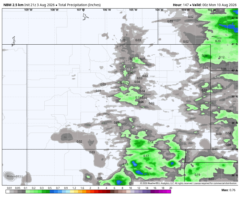
image
NBM precip to next Sunday evening shows only 0.02” in the Pagosa area and 0.1” in our mountains.
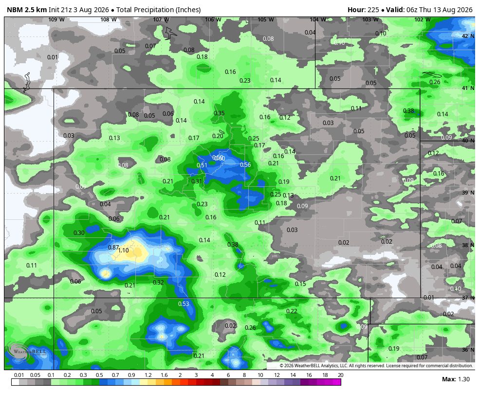
image 2
NBM precip to next Wednesday (Aug 12th) evening shows 0.32” in the Pagosa area and 1.5” in our mountains. The return of monsoon moisture begins Monday the 10th.


10 Aug to 18 Aug… The ridge will slide to our east Sunday into Monday. Monday and Tueday will see weak showers and thunderstorms through out the area with small hail, gusty winds. Wednesday (12th) and beyond will see widespread monsoon thunderstorms with potential for moderate to heavy rain.

2 week precip
Euro ensemble precip to 18 Aug shows 1.65” in the Pagosa area.
3 Aug to 18 Aug
This is Euro ensemble 24-hour precip amounts for the Pagosa Springs area to 18 Aug. It’s read left to right, and times are in Zulu. The top chart shows 24-hour precip amounts for 50 versions of the Euro forecast model. The bottom chart graphs the control, mean, and range of the 50 versions.
There’s a slight chance for a few weak storms through 10 or 11 Aug and then it’s more active through the rest of the period.

The next post will be Wednesday evening.

– Arleen

Pagosa Weather Blizzard Level Sponsor

Pagosa Weather Storm Sponsor

Picture of Arleen Pro

Arleen Pro

I grew up in Montana where my love of the mountains is rooted. I served in the Air Force, forecasting aviation weather, for 24 years. I had eight assignments and my favorites were Colorado, Alaska, Korea, and Germany. I deployed several times, including to Iraq and Afghanistan. After RV traveling for nine years, Shawn and I found paradise in Pagosa. Here we enjoy playing outside in the spectacular San Juan mountains!

Leave a Reply

Your email address will not be published. Required fields are marked *

Pagosa Weather Disclaimer and Release of Liability

This website makes no guarantees about nor bears any responsibility or liability concerning the accuracy or timeliness of the weather information published on this website. All weather information published on this website is for educational and weather enthusiast purposes only. We do not issue Storm Watches, Warnings or Advisories as that ability falls with the National Weather Service, who is the only institution allowed to issue such warnings by law. We are not in any way linked nor affiliated with the National Weather Service, although we do share information and relay weather watches/ warnings, etc. Use of the information on page is at your own risk/discretion, and we are not responsible for any personal/property damages, injury or death associated with weather forecasts, reports or other information as well as communication exchanged in private messages and/or person.

Terms of Use                  Privacy Policy

© 2026 Pagosa Weather 

Website Design by : Brandon