

This microburst snowshower was really cool yesterday! – pic taken 4/6/2026
Tuesday – 7 Apr 2026 – 2:45pm
The past…
Stevens Field Observations
Sunday: High: 62, Low: 24, Peak wind: 17mph
Monday: High: 61, Low: 25, Peak wind: 22mph
| Average High | Record High / Year | Average Low | Record Low / Year |
| 56 | 74 / 1991 | 23 | 10 / 1956 |
Precipitation summary… There has been no recent measurable precip.
Current satellite and radar…
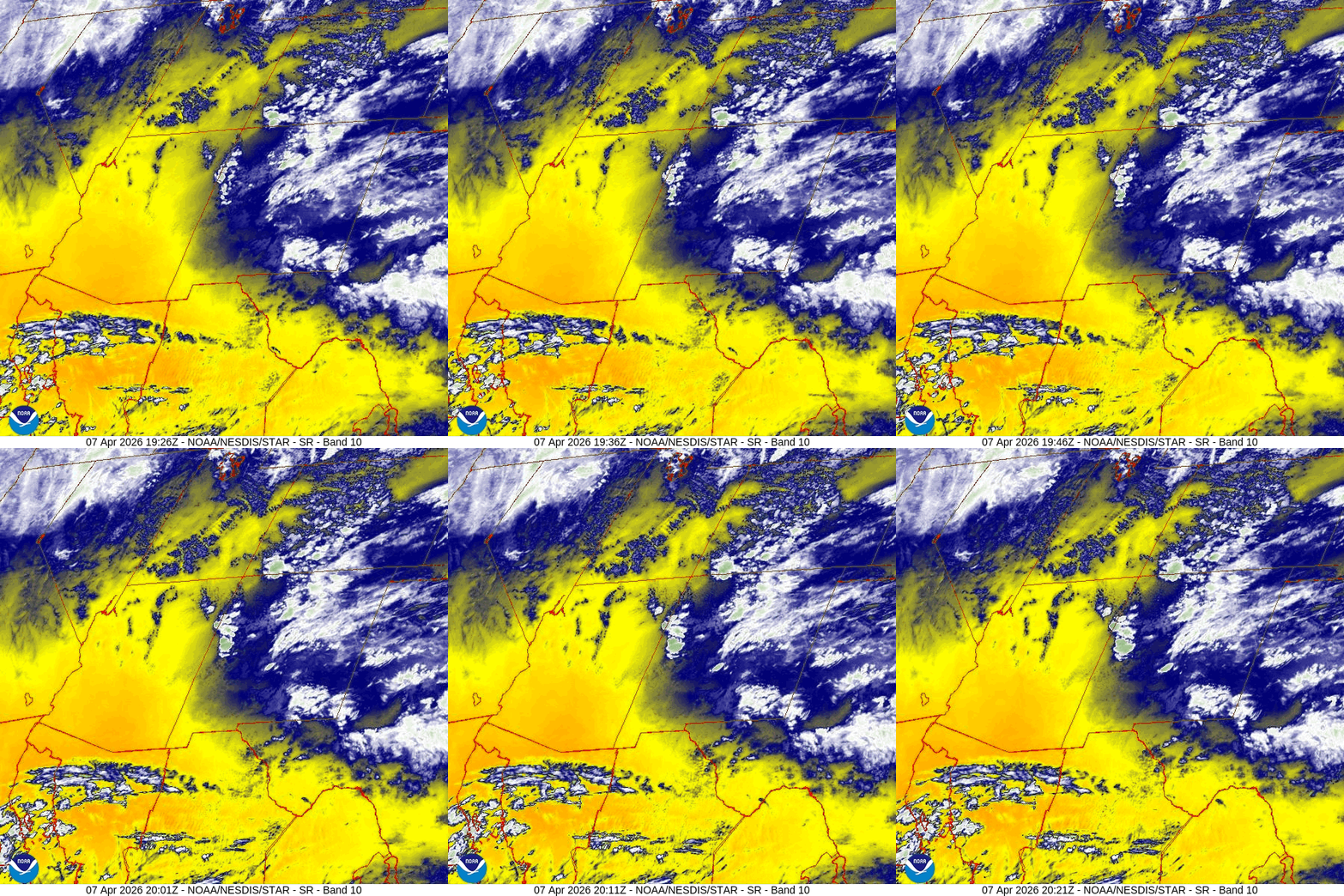

Forecast highlights…
*** Scattered showers will end Tuesday evening. ***
*** Mostly sunny and dry Wednesday through Friday evening. ***
*** Precip amounts increasing late Friday into next Tuesday morning. Expect winter driving conditions on Wolf Creek Pass. ***
Forecast details…
Rest of Tuesday… A surge of moisture and instability is kicking up hit and miss showers and a thunderstorm or twoTuesday afternoon. They’ll end around sunset. Precip amounts will be light and spotty.
Wednesday through Friday evening… A transient ridge will move through and temporarily dry us out.
Friday night into next Tuesday morning (14 Apr)… A double barrel low will take a more favorable tack for us. Occasional bands of showers will move through. Snow levels will gradually lower with a chance for few snowflakes in the Pagosa area Monday night.
Snow levels…
Friday afternoon through Saturday afternoon: around 10,500ft
Sunrise Sunday: around 9,000ft
Sunrise to sunset Monday: 8,000ft to 8,500ft
Monday night into Tuesday morning: 7,500ft to 8,000ft
Precip forecast…
Wolf Creek pass area: 6-12” of snow
Pagosa Springs area above 8,000ft: 0.50” to 0.75” of rain and 1” of snow Monday night
Pagosa Springs area below 8,000ft: 0.50” to 0.75” of rain and a trace of snow Monday night
*** Timing and precip amounts are still uncertain. I’ll adjust the details as the data gets better. ***
Temps…
Tuesday night lows will be in the mid 20s to the mid 30s.
Wednesday, Thursday, and Friday highs will be in the low to high 60s and lows will be in the high 20s to the mid 30s.
Saturday highs will be in the mid 50s to the low 60s and lows will be in the low to high 30s.
Sunday highs will be near 50 to the high 50s and lows will be in the low to high 30s.
Monday highs will be in the mid-40s to the low 50s and lows will be in the high 20s to the low 30s.
Next Tuesday highs will be near 50 to the high 50s and lows will be in the low to high 20s.
Winds…
Wednesday through Saturday, each afternoon gusts will be around 20mph in the Pagosa Springs area and 30-40mph in the high country.
Sunday and Monday, each afternoon gusts will be around 25mph in the Pagosa Springs area and 35-45mph in the high country.
Next Tuesday afternoon gusts will be around 20mph in the Pagosa Springs area and 30-40mph in the high country.

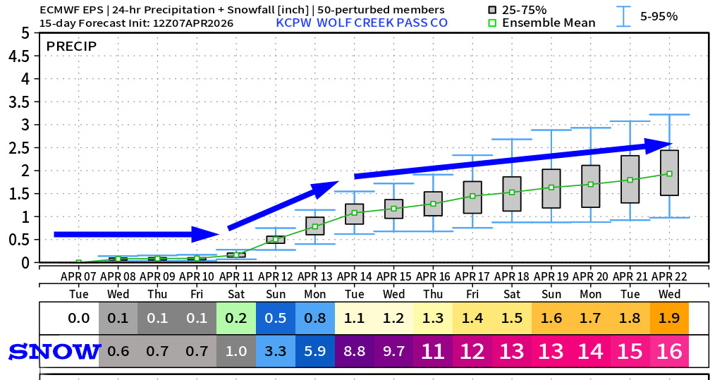
Precip amounts are trending up.
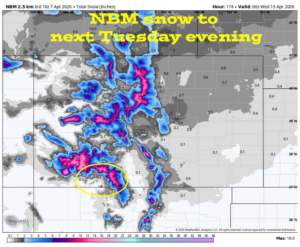
12 Apr to 20 Apr… The first two days of this period look active with a chance for precip. The second part hints at the pattern staying active with more chances for precip.
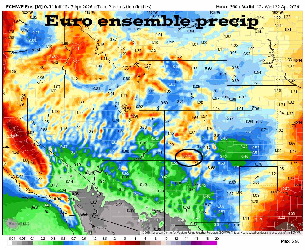

There are scattered showers with low precip amounts today. Wednesday through Friday evening should be mostly dry. Friday night to next Tuesday will be wet. For the rest of the period it stays active but there is a lot of uncertainty.
The next post will be on Thursday afternoon.
– Shawn


3 Responses
Hi there. Always grateful for your great forecasts. My mom isnt a Facebook person. Where else can she access your forecasts? Are you on Nextdoor?
Thaddeus, have her enter her email for Pagosa Weather updates on the front page of our website. The box it between “Pagosa Weather Forecast” and “Recent Pagosa Weather Posts” on our front page: pagosaweather.org
Or send me her email.
Arleen
Thank you so much