

Sunset clouds over Pagosa Peak – Pic taken 12/20/2025
Tuesday – 23 Dec 2025 – 6:45pm
The past…
Stevens Field Observations
Sunday: High: 52, Low: 25, Peak Wind: 9mph
Monday: High: 58*, Low: 24, Peak Wind: 9mph
* New record high beat previous record high 57 set in 1906. *
| Average High | Record High / Year | Average Low | Record Low / Year |
| 38 | 56 / 1906 | 4 | -28 / 1990 |
Precipitation summary… There has been no recent measurable precip.
Current satellite and radar…

There is nothing on radar in our area Tuesday afternoon.
Forecast highlights…
*** Christmas rain for Pagosa and snow for Wolf Creek. ***
*** Wednesday afternoon through Sunday morning expect periods of poor visibility, falling snow, and slick roads in the mountains. ***
*** Sunday afternoon through next Wednesday will be mostly sunny, with light winds, warmer than average temps, and dry weather. ***
Forecast details…
Rest of Tuesday… The giant, blocking, evil ridge has finally moved to our east. Mid and high clouds will continue to move through the region but we’ll stay dry.
Wednesday through Sunday morning… A low will wobble around the CA coast region. This puts us on the eastern edge of moisture and precip. Precip amounts are trending down – boooo hissss.
Specific timing and precip amounts…
Wednesday afternoon through Sunday morning precip will start as scattered showers Wednesday afternoon, ramp up Wednesday night, fall on and off through Christmas evening, and then become more hit and miss showers through Sunday morning.
Expect periods of winter driving conditions in the mountains with poor visibility, falling snow, and slick roads.
Precip amounts Wednesday night through Friday evening…
Mountains above 10,000ft: 4-8” of snow
Pagosa area: 0.10” to 0.30” of rain
Most of the precip will fall midnight Wednesday to midnight Thursday.
Precip amounts Friday night through Sunday morning…
Mountains above 8,500ft: 3-6”
7,500ft to 8,500ft: up to 1” – would fall at night and then melt during the day
Below 7,500ft: “rainflakes” – a dusting at best
Sunday afternoon through next Wednesday… A ridge will build back over the region. We’ll have mostly sunny skies, temps 10 degrees warmer than average, light winds, and dry weather.
Temps…
Wednesday highs will be in the high 40s to mid-50s and lows will be in the high 20s to high 30s.
Christmas and Friday highs will be in the mid to high 40s. Christmas night lows will be in the low to high 30s. Friday night lows will be in the mid-20s to the mid-30s.
Saturday and Sunday highs will be in the low to mid 40s and lows will be in the high teens to high 20s.
Monday and next Tuesday highs will be in the mid-40s to low 50s and lows will be in the high teens to mid-20s.
Winds…
Wednesday afternoon peak winds will be around 10mph in the Pagosa area. In the high country, winds will gust 20-25mph.
Thursday and Friday afternoon gusts will be 15-20mph in the Pagosa area. The windy spots could gust to 25mph Friday afternoon. In the high country, winds will gust 35-45mph.
Saturday through next Tuesday, afternoon peak winds will be 10-15mph in the Pagosa area. In the high country, afternoon gusts will be 20-25mph.

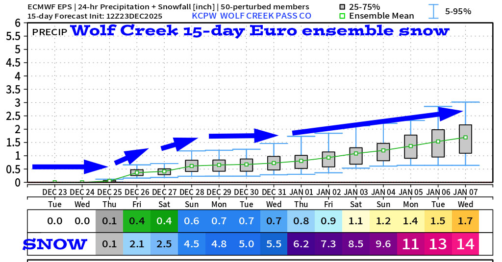
31 Dec through 7 Jan… The forecast models are all over the place for this period. The good news is that the pattern should remain active. Outcomes range from light amounts of precip to another pretty good storm.


The next post will be on Christmas.
– Shawn


