

Prairie smoke flowers near the Piedra River – Pic taken 5/9/2024
If images fail to load in the email, please click the title of the post. Thanks!
Friday – 10 May 2024 – 9:40am
The past…
At Stevens Field the high temperature yesterday afternoon was 56. The low this morning was 37.
The peak wind in the last 24 hours at Stevens Field was 25mph.
| Average High | Record High / Year | Average Low | Record Low / Year |
| 67 | 82/ 1989 | 29 | 18 / 1950 |
Precipitation summary… We got a little precip last night. Wolf Creek Pass got around 2” of snow. There are some impressive precip and snow amounts in the CoCoRaHS maps below.

Precip amounts are impressive across the San Luis Valley and in the Walsenburg area.

Our neighbors to the north, Creede, had 4”.
13” was reported south of La Veta Pass and near Salida!
Forecast discussion…


Forecast highlights…
*** Scattered afternoon showers and isolated thunderstorms through Thursday. Friday and Saturday afternoons will be the most active. ***
*** Wolf Creek Pass will have periods of winter driving conditions into Sunday. ***
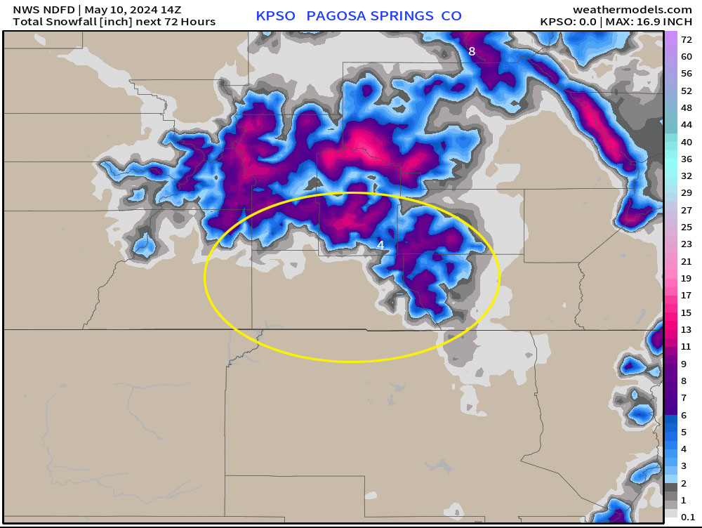
Friday through Saturday… The cut-off low is currently over NV and will slowly move east over the next 2 or 3 days – the forecast models vary on timing. There is enough moisture and instability to kick up scattered showers.
The best chance for showers and thunderstorms is Friday and Saturday afternoons.
Snow levels on our side of the mountains will bounce around between 9,000ft and 10,500ft during the period. Snow levels in the San Luis Valley were around 7,800ft this morning but will rise above 8,500ft by noon today and continue to rise to 10,000ft by late afternoon.
Total precip amounts for Friday and Saturday…
Valley: 0.25” to 0.50” – it will fall in bursts mostly Friday and Saturday afternoons
Wolf Creek Pass area: 3-7”
Higher peaks in our mountains: up to 12”
Winds… Afternoon gusts will be 15-20mph. Isolated stronger gusts are possible near showers and thunderstorms.
Temps… Highs will be in the low 50s to low 60s and lows will be in the high 20s to mid-30s.

Other forecast models expect us to get over an inch of precip, but I’m skeptical of those higher amounts.
Sunday through Thursday… Residual moisture and instability will lead to spotty afternoon showers and a thunderstorm or two. It’s not a monsoon pattern, but it will act a little like it. Precip amounts each day will be low and spotty.
Winds… Sunday afternoon gust will be 20-25mph. The rest of the period afternoon gusts will be 15-20mph. Isolated higher gusts are possible near showers and thunderstorms.
Temps… Sunday highs will be in the high 50s to mid-60s and lows will be in the high 20s to mid-30s. The rest of the period highs will be in the low 60s to low 70s and lows will be in the high 20s to high 30s.
My next forecast post will be tomorrow.
– Shawn


One Response
A friend if mine in Creede posted pics of about 6″ of snow thetr this morning!