

It’s time for everyone’s snow dance!
If images fail to load in the email, please click the title of the post. Thanks!
Friday – 22 Dec 2023 – 11:45am
The past…
At Stevens Field the high temperature yesterday afternoon was 40. The low this morning was 22.
The peak wind at Stevens Field yesterday afternoon was 6mph.
| Average High | Record High / Year | Average Low | Record Low / Year |
| 37 | 57 / 1906 | 4 | -30 / 1949 |
Precipitation summary… A couple of folks reported 0.01” precip in the last 24 hours, but most had zero.
Forecast discussion…


Forecast Highlights…
*** The heaviest precip will fall Friday night. Scattered showers will linger through Sunday. ***
*** Travel over Wolf Creek Pass will be sketchy late Friday evening to Sunday evening. ***
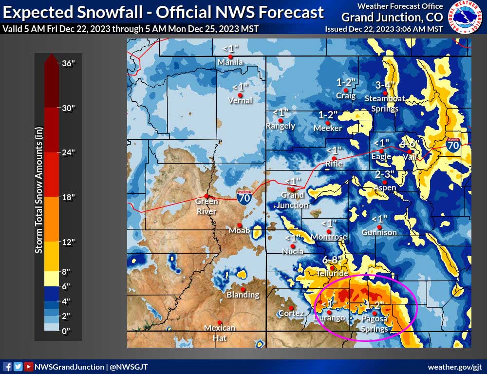
*** The Grand Junction NWS has issued a WINTER STORM WARNING for the southwest San Juan Mountains. 8-18” of snow is expected with snowfall rates exceeding 2” per hour tonight. The warning is valid from 5pm Friday to 5am Sunday. This does not include Pagosa Springs. ***

Friday afternoon… The ridge will be to our east. Upper-level southwest flow will start pushing more clouds into the region ahead of tomorrow’s system.
Winds… Peaks Friday afternoon will be 5-10mph.
Temps… Highs Friday will be in the low to high 40s.
Friday night through Sunday night… A complicated double-barrel low pressure system will impact us. The first one will move to our south on Saturday. The second will move over Colorado on Sunday.
Ideally, we need moist flow from the south or southwest and strong storm energy for good precip. Things line up best Friday night and then marginally to Saturday evening. Flow on Sunday doesn’t line up well for us but proximity to the secondary low will kick up scattered snowshowers. I don’t expect much additional accumulation on Sunday.
Forecast confidence… It will rain tonight over much of the valley, possibly up to 8,200ft. I’m not confident about the snow levels and how much of the forecast liquid equivalent will be snow in the valley. A difference of just a couple of hundred feet will have a big impact on snow amounts.
Timing… The first few showers will develop over the mountains Friday evening and over the valley by 11pm. The heaviest precip will fall from 11pm tonight to 7am Saturday morning. Precip will be more scattered into Saturday evening and become even more hit and miss on Sunday.
Snow levels… Friday night snow levels will be 8,000 to 8,200ft. They’ll gradually drop to 7,600ft between sunrise Saturday and noon and continue to gradually drop to 7,200ft by sunset on Saturday. As snow levels drop farther Saturday night, moisture and precip will decrease.
Snow amounts…
Below 7,800ft: 1-3” – most of this will fall Saturday afternoon and evening
Valley above 7,800ft: 3-7” – most of this will fall Saturday morning to Saturday evening
Mountains: 12-18” – most of this will fall Friday night to Saturday night
Winds… Peaks will be 10-15mph
Temps… Friday night lows will be in the low to high 30s. Saturday highs will be in the mid-30s to low 40s and lows will be in the mid-teens to mid-20s. Highs Sunday will be in the low to high 30s and lows will be in the low single digits to low teens.

Christmas Day through Thursday… A spotty snowshower or two is possible over the mountains on Christmas Day, but I don’t expect any snow to accumulate.
Ridging will build over the region during the middle of the week and give us lots of sun, light winds, and temps near the seasonal average.
Winds… Peaks Monday and Tuesday afternoons will be 10-15mph. Wednesday and Thursday peaks will be 5-10mph.
Temps… Highs on Christmas will be 30 to 40 and lows will be 0 to 10. Highs Tuesday will be in the low 30s to low 40s and lows will be in the mid-single digits to mid-teens. Highs Wednesday and Thursday will be in the high 30s to mid-40s and lows will be 10-20.
My next post will be tomorrow.
– Shawn


