

Rizz scrutinizes incoming thunderstorm in the wilderness, high country Friday night (June 26th). Rizz, the Columbine District Burn Boss & Jr Weather man, is now deployed on the Gold Mountain fire. Our thoughts and prayers are with all the firefighters & communities impacted by the wildfires. Photo credit to roaming weather reporter, Shawn. (select title of post to see picture)
Tuesday – 30 Jun 2026 – 3:30pm
Stage 2 Fire Restrictions go into effect on Wednesday, July 1st for the entire San Juan National Forest. This means NO CAMPFIRES anywhere. There are additional restrictions for smoking, welding, and explosives and additional details will be released once the Forest Order is signed.
The past…
Stevens Field Observations
Monday: High: 76, Low: 44, Peak wind: 32mph, Afternoon humidity: 7-10%.
Tuesday: High: 75 at 3pm, Low: 38, Peak wind: 28mph, Afternoon humidity: 22-27%.
| Average High | Record High / Year | Average Low | Record Low / Year |
| 82 | 97 / 1990 | 42 | 28 / 1942 |
Precipitation summary… There has not been any precipitation reported in the last 48 hours in our area. Roaming weather reporter, Shawn, reported light rain and one BOOM off of Park Creek past Wolf Creek.
Current satellite and radar…

The BIG picture today: Active areas of low pressures in Canada will slowly weaken and fill over the next few days. Trough is anchored into Great Basin. Ridge of High pressure over the southeast United States. That puts us in the middle with the jet overhead and subjected to squeeze play. Though it is weakening. Of note, the monsoon moisture is moving around area of High pressure from the Gulf into Mexico. If the ridge will shift west, so will the moisture plume. And we see our first disturbance in the Pacific of the season. There is not any forecast movement with it at this time. But it fed just enough moisture into the northeast flow to give us some clouds today!

Forecast highlights…
*** Tuesday and Wednesday: Breezy, Wind Gust to 30mph ***
Note: We do not meet Red Flag Warning criteria today BUT Critical fire weather conditions still exist. Exercise extreme caution in activities outside. Red Flag Warnings are in affect for areas to our west, north, and east. Follow this link to Red Flag Warning areas.
*** See Fire/Smoke Report at the bottom of this post***
Tuesday through Friday (Jun 30 – Jul 3)… We’ll be predominantly partly cloudy. We’re under the squeeze play between a strong area of high pressure anchored over the southeastern United States and the long-wave trough set up over the Great Basin spinning off shortwaves. Upper-level dry flow will be out of the southwest. It will remain sunny, dry, and warm with gusty afternoon winds.
Temps… Highs will slowly warm each day from lo-70s to upper-70s today to upper-70s and mid-80s by Friday. Lows will be near 40 to the mid-40s increasing to mid-40s to upper-40s by Friday.
Winds… Strong Breeze with afternoon gusts on Tuesday to 30mph. Then afternoon gusts to 25mph Wednesday through Friday.
Saturday and Sunday (Jul 4th & 5th)… Partly to Mostly Cloudy. Polar Front Jet will be weakening and moving north. The Subtropical Ridge over the southeast will weaken, shift west and reform over Colorado. We’ll be under weak southwest flow. Though we will still be dry and warm.
Temps… Highs Upper-70s to upper-80s. Lows will be mid-40s to the upper-40s.
Winds… Moderate Breeze with mid-afternoon gusts to 20mph.
Monday (Jul 6th)… Will this be the day to welcome the Monsoon? We’ll be partly cloudy with mostly cloudy skies in the afternoon. We have a chance for thunderstorms and rainshowers with small hail from about noon to 5pm. At this time, it will be a monsoon day. But a sputter day… That is we will have more lightning than we have rain. Predictable water numbers are low at this time.
The models have really been waffling on exactly where the ridge will set up. If it sets up to our east, we may have a fun first monsoon day with measurable rain. If it sets up over our head, some folks will get measurable rain. If it sets up to our west, only a few select folks will get measurable rain.
Temps… Highs Upper-70s to upper-80s. Lows will be mid-40s to the upper-40s.
Winds… Increasing moisture will finally give us relief from the constant afternoon winds. Light Breeze with mid-afternoon gusts to 15mph. Expect higher gusts associated with thunderstorms.
07 Jul to 15 Jul… The subtropical high will try to set up over central Colorado. Monsoon is trying to set up!


It’s dry through the 5th of July. Just chances of scattered showers and thunderstorms till the 15th of July. It appears that some runs are detecting an uptick around the 11th. But this is not decisive. We want to see stronger signals for a good monsoon. Show me more blue and yellow colors!

Fire and Smoke Update
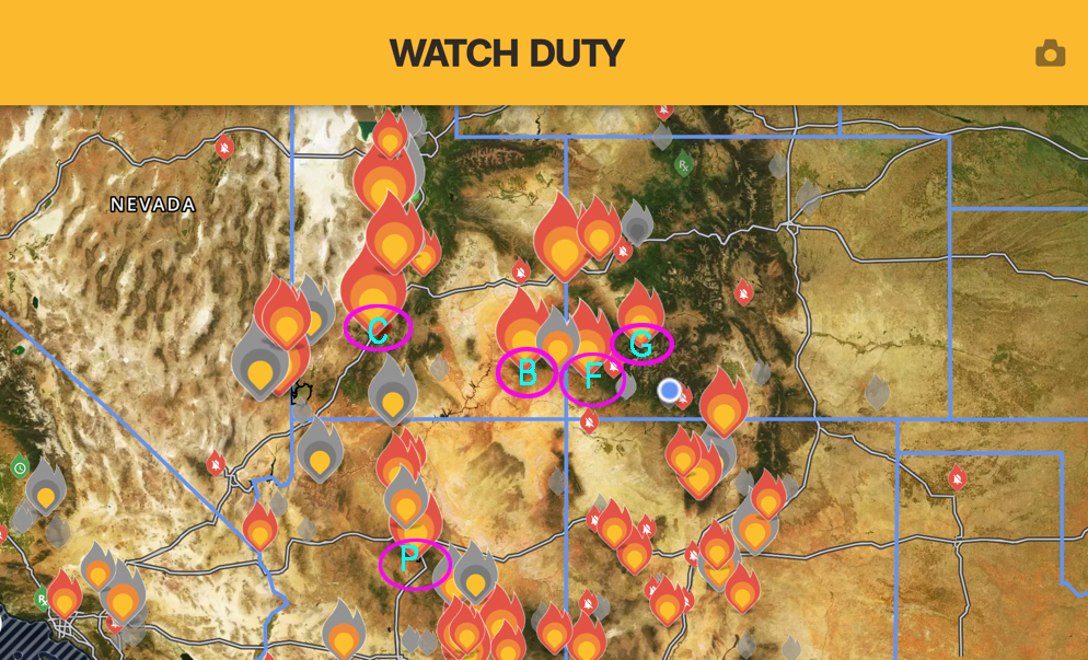
A number of fires are raging throughout the west. Thanks to our first responders, there are not any active fires being reported in Archuleta County at this time. The fires that could impact us with smoke over the next week are:
The Cottonwood Fire near Beaver Utah (impacted us early Wednesday this past week). Currently at 93,606 acres. May impact us again later in the week as we come under a more westerly flow.
Babylon Fire near Blanding, Utah is at 53,870 acres.
Ferris Fire northeast of Dolores. In three days it has already burned 19,600 acres.
Gold Mountain Fire near Ouray, Colorado. It is at 8,276 acres. We can occasionally see the smoke plume to the northwest, past Cimmarona. Amazingly, it is only about 60 miles from here even though it takes hours to drive there.
The Pocket Fire near Sedona, Arizona. It has doubled in size in two days to 15,375 acres. It is directly southwest of us so the smoke will move our direction.
- My next post will be Thursday.
– Arleen


