
Happy pup at the lake on a beautiful spring day! – pic taken 4/21/2026
Thursday – 23 Apr 2026 – 2:45pm
The past…
Stevens Field Observations
Tuesday: High: 71, Low: 31, Peak wind: 25mph
Wednesday: High: 64, Low: 34, Peak wind: 35mph
| Average High | Record High / Year | Average Low | Record Low / Year |
| 61 | 76 / 1943 | 25 | 11 / 1963 |
Precipitation summary… There has been no recent measurable precip.
Current satellite and radar…

There is nothing on radar in our area Thursday afternoon.
Forecast highlights…
*** Thursday afternoon the prescribed fire in the Turkey Springs area is on-going. ***
*** Friday prescribed fire in the Sauls Creek area east-northeast of Bayfield. Smoke will be pushed towards the northeast across northwest Archuleta County. ***
*** Hard freeze likely tonight and then again Sunday and Monday nights. ***
*** Weak chances for a few raindrops through Saturday, but most of us will stay dry. ***
*** Breezy each afternoon through Tuesday. ***
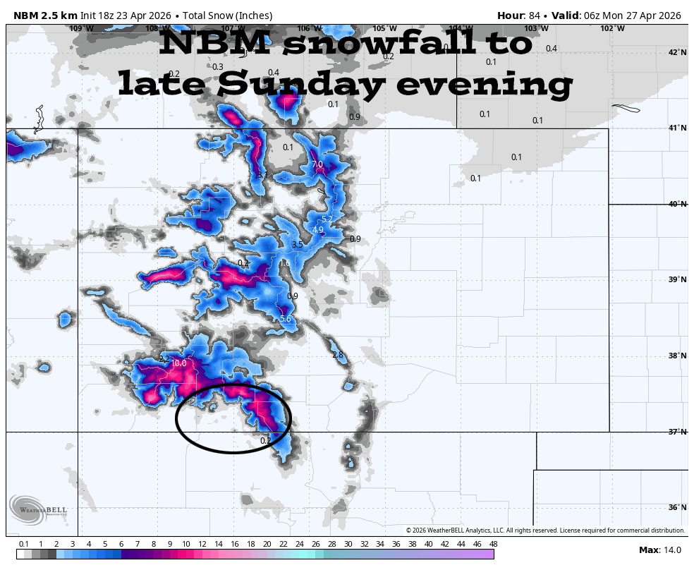
*** Scattered showers Saturday night into Sunday evening. EXPECT WINTER DRIVING CONDITIONS ON WOLF CREEK PASS. ***
*** Chance for another round of showers next Thursday and Friday. ***
Forecast details…
Rest of Thursday through Saturday afternoon… Clouds will increase Friday and Saturday ahead of a low pressure system. Afternoon winds will remain breezy.
Saturday night into Sunday evening… A low pressure system will move through the southwest US. An influx of moisture and instability will trigger scattered showers and thunderstorms.
Snow levels will be above 8,500ft.
My precip forecast…
Mountains above 9,000ft: 5-10” of snow
Pagosa Springs area: 0.25” to 0.50” of rain. Folks above 8,000ft could see a few snowflakes mixed with the rain.
Sunday night through Wednesday morning… We’ll revert back to a wishy-washy pattern with upper-level southwest flow and a little bit of moisture and instability. We’ll see scattered clouds and an isolated shower, mostly over the mountains.
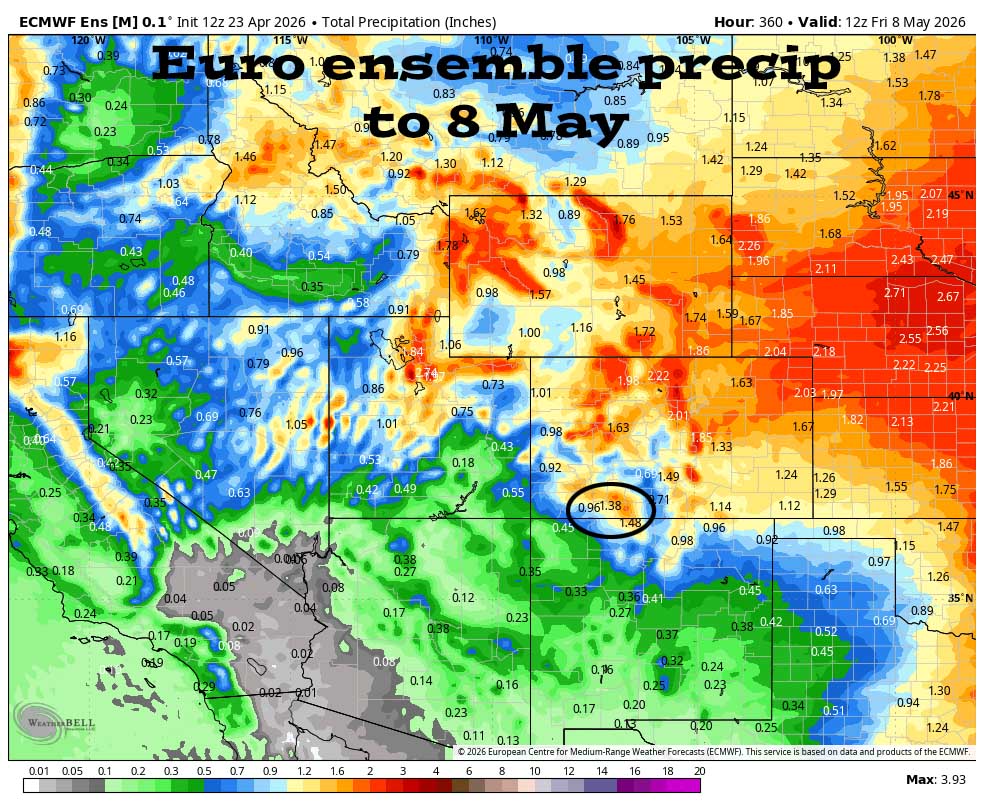
Wednesday afternoon into next Friday afternoon… Another low-pressure system could move through the region and kick up another round of scattered showers. There is still a lot of uncertainty.
Temps…
*** Thursday night lows will be in the low to high 20s ***
Friday and Saturday highs will be in the mid-50s to the low 60s. Friday night lows will be in the mid 20s to the low 30s. Saturday night lows will be in near 30 to the high 30s.
Sunday highs will be in the mid 40s to the low 50s and *** lows will be in the low to high 20s ***.
Monday highs will be in the low to high 50s and *** lows will be in the low to high 20s. ***
Tuesday, Wednesday, and next Thursday highs will be in the mid-50s to the low 60s and lows will be in the mid 20s to the mid 30s.
Winds…
Friday through Tuesday, each afternoon gusts will be 25-30mph in the Pagosa area and 35-45mph in the high country.
Wednesday and next Thursday, each afternoon gusts will be around 20mph in the Pagosa area and 25-35mph in the high country.
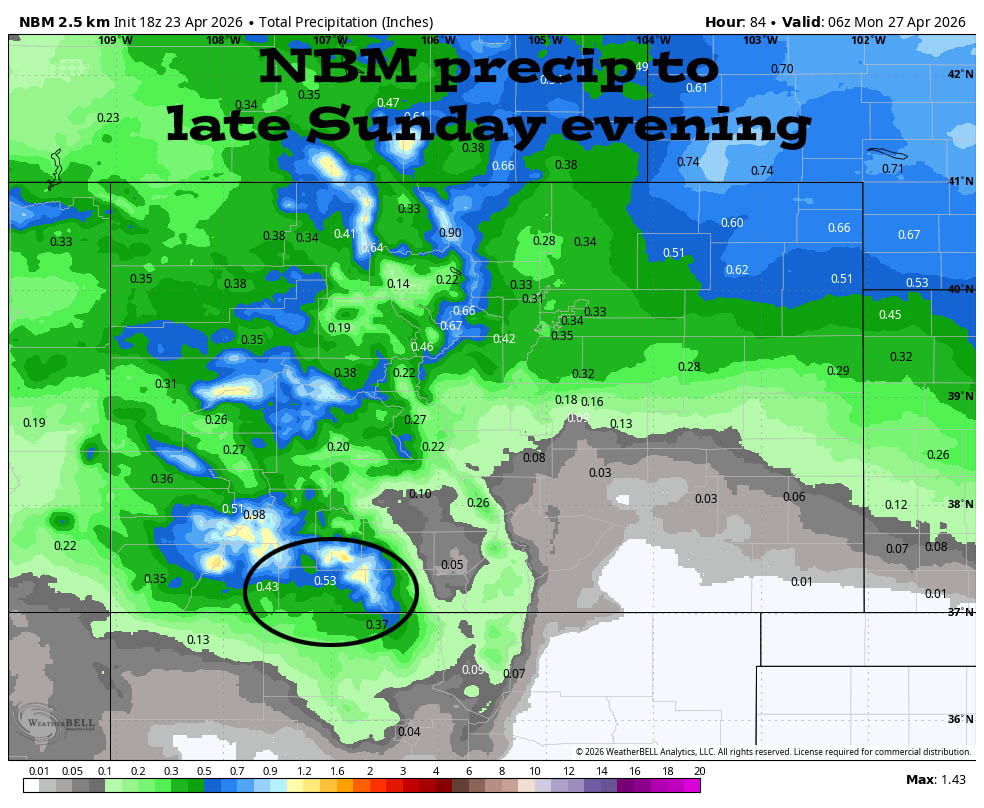
Precip amounts have trended up.
30 Apr to 8 May… After a weak storm Wednesday afternoon into next Friday, the forecast models are trying to dry out.
Precip amounts have trended up for the Saturday night/Sunday storm.

It’s mostly dry through Saturday afternoon and then there’s a storm Saturday night into Sunday evening. The forecast models are hinting at another storm late Wednesday into next Friday, but there’s a lot of uncertainty. The rest of the period looks less active and is trying to dry out.
The next post will be on Saturday afternoon.
– Shawn


2 Responses
Hello,
Is there a way to sign up to receive your weather reports via email? Thank you!
Sean, Yes! I just submitted your email. You will receive an email asking to confirm.
Arleen