

Pagosa Peak peeked out yesterday during a break in the rain after 3pm.
Saturday – 11 Oct 2025 – 1:00pm
We are still under the impact of Tropical Storm Priscilla and she is starting to break a few dishes! River and streams are up. Ephemeral creeks are full. Rocks and mud are flowing onto roads in prone areas. We have had exactly 3.40″ of rain at our home, 7 miles northwest of Pagosa as of 11:00am Saturday morning since Thursday night. A Flood Watch and a Flood Warning are out! See the details below.
Thank you for your reports!
The past…
Stevens Field Observations
Friday: High: 55, Low: 50, Minimum relative humidity: 88%, Peak Wind: 9mph
| Average High | Record High / Year | Average Low | Record Low / Year |
| 68 | 80 / 1950 | 28 | 15 / 1913 |
Precipitation summary… Light to moderate rain fell across all areas of Archuleta County. There was a bit of a break in the late afternoon.

Current Satellite and Radar…
Current Satellite

Water Vapor Satellite at Noon. Enhanced area will kick off thunderstorms in our area this afternoon. Dry air will move in tomorrow morning. Remnants of TS Raymond will move in on Monday. Area of low pressure to northwest will impact our area on Wednesday and Thursday.
Current Radar
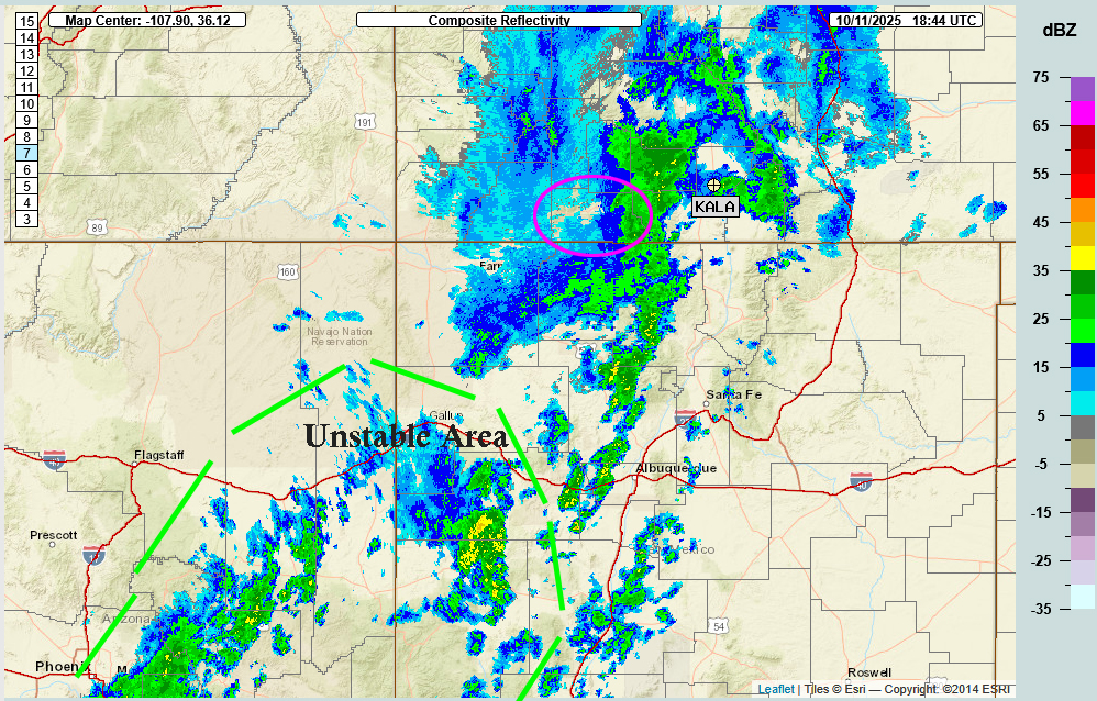
Radar at 12:44pm Saturday – Moisture is streaming out of the southwest. Heavier area of moisture is moving out of the county. An enhanced unstable area will move in later this afternoon with thunderstorms, brief periods of heavy rain, small hail, lightning, and gusty winds.
San Juan River
The San Juan River in Pagosa Springs has exceeded it previous record high flow for 11 Oct.
Old record: 1,080cfs
Flow at 10am on 11 Oct 2025: 2,540cfs and rising

***Flood Watch***
1158 AM MDT Sat Oct 11 2025
…The National Weather Service in Grand Junction has issued a Flood Advisory for the following rivers in Colorado…
San Juan River at Pagosa Springs affecting Archuleta County.
For the San Juan River…including Pagosa Springs…elevated river levels are forecast.

FLOOD WARNING
Flood Warning
National Weather Service Grand Junction CO
1151 AM MDT Sat Oct 11 2025


...FLOOD WARNING IN EFFECT UNTIL MIDNIGHT MDT TUESDAY NIGHT...

* WHAT...Flooding caused by excessive rainfall is expected. There is a potential for another round of heavy rainfall on Monday and Tuesday, which could lead to more flooding.

* WHERE...A portion of southwest Colorado, including the following counties, Archuleta, Hinsdale, La Plata and San Juan. North of Vallecito Reservoir.

* ADDITIONAL DETAILS...
  - At 1142 AM MDT, Emergency management reported flooding is ongoing north of Vallecito Reservoir.
  - Some locations that will experience flooding include... Vallecito.
  - http://www.weather.gov/safety/flood

Tropical Storm Priscilla is being sponsored by the Springs Resort! Huge thanks to the team at The Springs Resort for being our Storm sponsor!
Forecast highlights…
*** Priscilla will continue to impact us till Sunday morning. Saturday will be Cloudy with Rain, occasionally heavy, and a few embedded Thunderstorms. ***
*** FLOOD WATCH through Sunday morning at 6am. Let us know of any areas of flooding or damage in your area. ***
***FLOOD WARNING IN EFFECT UNTIL MIDNIGHT MDT TUESDAY NIGHT***
***Raymond visits Monday through Wednesday. ***
Forecast details…
Saturday through Sunday morning… Priscilla’s remnants are entrained into the southwest flow ahead of a trough along the West Coast. The long-wave trough will remain anchored there but kick off a mesoscale trough that will move through our area Sunday and have clearing behind it.
We’ll see a bit of a break in the rain around this time. Then the enhanced areas on satellite and radar will move into our area kicking off isolated thunderstorms late this afternoon till late this evening. Storms will produce brief periods of heavy rain, small hail, lightning, and gusty winds.
After midnight we’ll have light rain and spotty showers.
Snow… A subtropical feed means relatively warm air and mostly rain. Snow levels are 13,000 to 14,000 feet and then drop down to 12,000 feet by Sunday morning. Then Sunday night it drops to 10,000 feet and increases again as we move into the week.
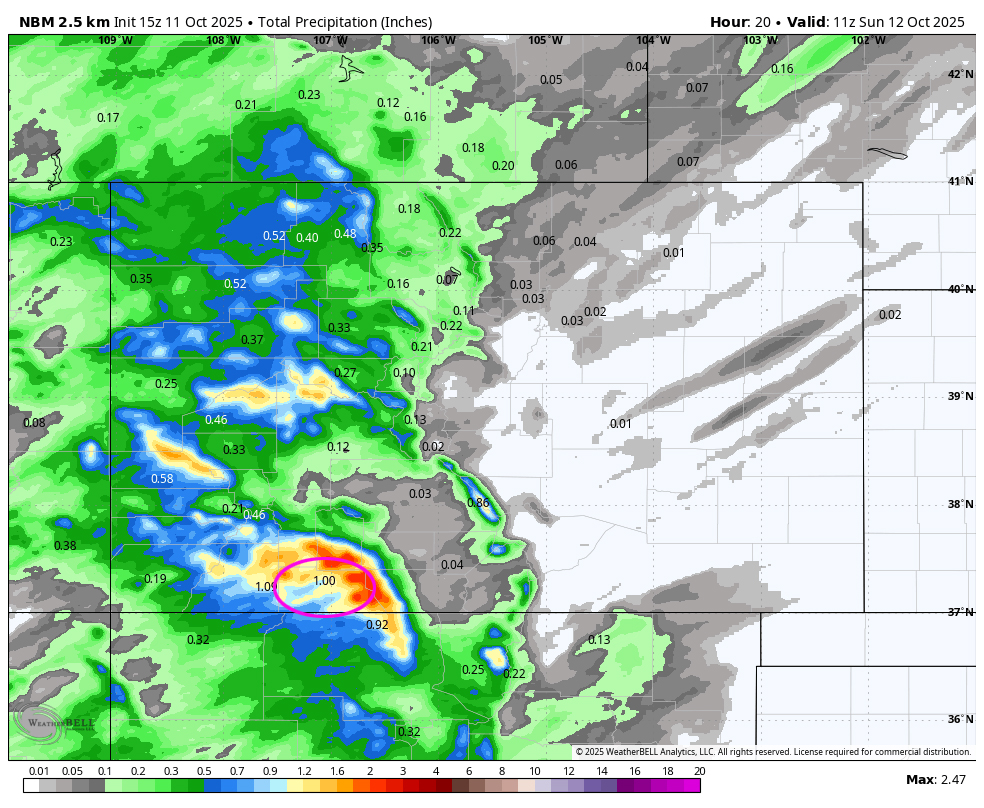

Sunday morning through Monday morning… We’ll be between systems with partly to mostly cloudy skies and a few spotty showers, and possible thunderstorms mostly over the mountains.
Monday afternoon into Wednesday Afternoon: The remnants of Tropical Storm Raymond will be transported into our area on the southwest flow along with rounds of storm energy and moisture through our area. A lot of the moisture will stay to the south in New Mexico. However, the energy and the flow will still be upsloping into the Southern San Juans. Expect widespread showers and a few embedded thunderstorms. Storms will produce brief periods of heavy rain, small hail, lightning, and gusty winds.

Euro Ensemble 72 hour product indicates 2.97″ of precip from Monday morning to Wednesday night at midnight. This product has been verifying well.
Thursday and Friday: We’ll be Mostly Cloudy with Scattered showers. The upper level low currently centered over western Oregon will drop into Great Basin area. We will have ample moisture already in place to kick off showers. In addition, a cold air mass will drop in behind bringing freezing temperatures to the area.
***SNOW: Snow level will drop to 8,500 feet Friday morning. We could see our first few snowflakes. Ground is too warn for accumulations***
Temps…
Saturday highs will be in upper 50s. Lows will be in upper 40s.
Sunday highs will be in the upper-50s to mid-60s. Sunday night lows will be in the low to high 30s.
Monday and Tuesday highs will be in the upper-50s to mid-60s and lows will be in the high 30s to high 40s.
Wednesday and Thursday highs will be in the upper-50s to low 60s and lows will be in the mid 30s to low 40s.
***NOTE: Hard freeze Friday morning in the mid 20s. (October 17th and beyond).***
Winds…
Each afternoon gusts will be around 15mph. Expect higher gusts on Sunday as trough moves through, of 20-25mph.
As always, stronger isolated gusts are likely near a shower or thunderstorm.
The 8-14 day period… The San Juans are the BULLSEYE! The models are consistent now with the tropical systems. We are going to get wetter!!!
We could see that first inch of snow or more the last week of October.
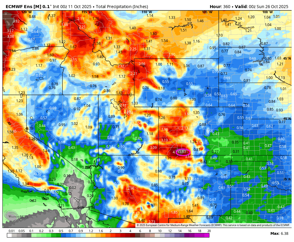
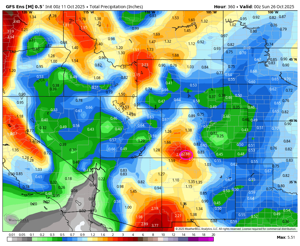
On the top, Euro ensemble precip to 26 Oct at 6am shows 5.63” in the Pagosa area! On the bottom, GFS ensemble precip has decreased and shows 2.88”. The Euro has been verifying better.
The next weather post will be tomorrow. Let us of any areas of flooding or damage in your area!
– Arleen


2 Responses
Hudson Lower Rio Blanco is flooding. Estimated greater than 5 feet.
Thank you, Katie. – Arleen