

Tommy enjoying the view from Thunder Mountain down onto Wolf Creek Pass. All was quiet today. – pic taken 4/8/2025
Tuesday – 8 Apr 2025 – 6:00pm
The past…
At Stevens Field the high temperature yesterday (Monday) was 59 and today it has been 63. The low this morning was 25.
The peak wind at Stevens Field on Monday was 27mph and today it has been 28mph.
| Average High | Record High / Year | Average Low | Record Low / Year |
| 56 | 75 / 1989 | 22 | 7 / 1973 |
Precipitation summary… There hasn’t been any reported precipitation in the last 48 hours.
Forecast discussion…
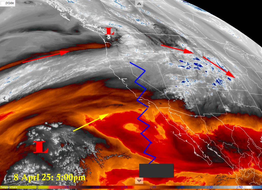
Water vapor satellite Tuesday afternoon – The ridge, jagged blue line, will be in control till Saturday. Even then it keeps the weather to our north.
There is nothing on radar in our area.
Forecast highlights…
*** Lots of sun! Temps 10-15 degrees above average till Saturday. ***
*** No precip for the next week. ***
Rest of Tuesday through Saturday… Sunny and warm. The ridge will be in control over us and our weather through Saturday.
Sunday and Monday: On Sunday a trough will push into northern Colorado. We’ll see some high clouds and gusty winds. Monday will be a bit cooler.
Temps…
Wednesday morning lows will be in the mid 20s to mid 30s. Highs will be in the mid 60s.
Thursday, Friday, and Saturday lows will be in the high 20s to mid 30s. Highs will be in the high 60s to low 70s. It will feel like summer!
Sunday and Monday will be cooler. Lows will be in the high 20s to mid 30s. Highs will be in the upper 50s to mid 60s.
Winds… Spring winds! Wednesday will be breezy with winds gusting up to 25mph. Thursday and Friday will calm a but with winds gusting only to 15 to 20mph during peak afternoon hours. Saturday will be breezy again with winds gusting 25 to 30mph. Sunday is going to be the windiest day of the week with winds gusting up to 38mph. Monday winds will settle.. just a bit with gusts to 25mph.
The 8-14 day period… There is a possibility of some light precipitation starting on 16th. Confidence is low and details are murky at this time. There is a cutoff low way off the coast moving our direction. Cutoff lows are difficult to track due to their erratic movement. It is a week out. A lot can change in that time.

Euro ensemble precip above to 6am on 24 Apr shows 0.36” for Pagosa. The GFS ensemble precip below shows .35″ for Pagosa. Both models are indicating a 1/4″ to 1/2″ of precipitation for our area over a week’s period of time.

My next forecast post will be on Thursday. We’ll be outside enjoying this spring weather!
– Arleen


